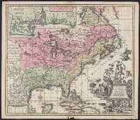
Appears in the author's Grosser atlas ... [between 1734 and 1750?], Covers North America from Quebec to the Gulf of Mexico, and to New Mexico in the west., In French, with title in Latin., and Includes decorative cartouche, historical notes and inset of "Les cos
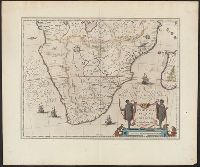
"Partes magis Septentrionales, quae hic desiderantur, vide in tabula Aethiopiae Superioris.", From the author's Theatre, Includes col. ill. of animals and ships, and decorative cartouche., Map text in Latin. Text on verso in French., and Relief shown pictorially.
Publisher:
Chez Iean Blaeu,
Subject (Geographic):
Africa, Southern--Maps--Early works to 1800
Subject (Name):
Blaeu, Joan, 1596-1673 and Blaeu, Willem Janszoon, 1571-1638. Theatrum orbis terrarum. French
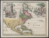
Includes col. ill. of ships, monsters, etc., Possibly from the 1639, 1641, or 1642 ed. of the author's Noveau theatre du monde ou nouvel atlas, or from the 1646, 1647, or 1649 ed. of J. Jansson's Nouvel atlas ou theatre du monde., and Relief shown pictorially.
Includes ill. of natives in upper left and right., Relief shown pictorially., Some French notes., and Yale's copy annotated in ink in upper right margin: Nr073.
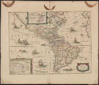
Appears in various eds. of Jan Jansson's Nouvel atlas., French text on verso., Includes ill. of ships and sea monsters, and insets showing "Polus Arcticus" region and "Terra Australis inc, and Sheet measures 50 x 59 cm. Stamp on verso: Yale, Horace Brown, 1900S.
Nova mappa geographica Americae Septentrionalis in suas praecipuas partes divisa
Description:
In French, with alternate title in Latin., Includes 18 insets and decorative cartouche., Prime meridians: Ferro and Paris., Relief shown pictorially., Title from upper margin., and Yale copy stamped on verso: Yale, Horace Brown, 1900S.
Publisher:
Sumptibus Ioh. Mich. Probst,
Subject (Geographic):
North America--Maps--Early works to 1800
Subject (Name):
Popple, Henry, -1743. Map of the British Empire in America and Probst, Jean George
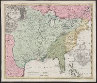
Appears in Homann Erben's Atlas geographicus major [1759 or 1763?]., Includes ill. and text., Relief shown pictorially., Some text in French., and Yale's card catalog notes "Fock catalogue no. 731 (fr. wh. acquired) gives date as ca. 1730"; and "In Homann J.B. Ne
Publisher:
[Homannianis heredibus?,
Subject (Geographic):
Louisiana--Maps--Early works to 1800 and North America--Maps--Early works to 1800
Subject (Name):
Hennepin, Louis, 17th cent and Homann Erben (Firm). Atlas geographicvs maior
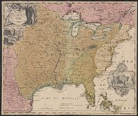
Includes ill. and text., Lowery refers to this version appearing in Homann's Atlas geographicvs maior exhibens tellurem seu globum terraqueum in mappis generalibus & specialibus ... (1759-[1781]), described in Phillips 622. Cf. Lowery 475., and Reference: Antiq
Publisher:
[s.n.,
Subject (Geographic):
Louisiana--Maps--Early works to 1800, Mississippi River Valley--Maps--Early works to 1800, and North America--Maps--Early works to 1800
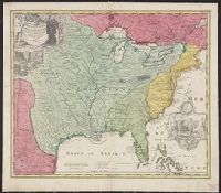