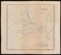
Expedition to the Rocky Mountains and Major Long's Expedition to the Rocky Mountains
Description:
Bookplate of Joseph Y. Jeanes., Engravings by Young & Delleker, Cephas Grien Childs, Alexander Lawson, Francis Kearney, and William Hay; after Stephen H. Long, Samuel Seymour and Titian Ramsay Peale., Some maps on double leaves., Spine title, on publisher's printed labels: Major Long's Expedition to the Rocky Mountains., and Text and atlas in slipcase.
Subject (Geographic):
Missouri River--Discovery and exploration, Ohio River--Discovery and exploration, United States--Discovery and exploration, and West (U.S.)--Discovery and exploration
Subject (Name):
Childs, Cephas Grier, 1793-1871, Hay, William, Jeanes, Joseph Y, Kearny, Francis, 1785-1837, Lawson, Alexander, 1773-1846, Long, Stephen H. (Stephen Harriman), 1784-1864, Peale, Titian Ramsay, 1799-1885, Say, Thomas, 1787-1834, Seymour, Samuel, active 1797-1822, United States. War Department, and Young & Delleker
Subject (Topic):
Discoveries in geography, Geology--West (U.S.), Glossaries, vocabularies, etc., Indians of North America, and Indians of North America--Languages--Glossaries, vocabularies, etc.
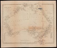
From John Lort Stokes's Discoveries in Australia (1846)., Includes index of counties and notes on explorers and discoveries., Map of Australia showing 19 counties in New South Wales, 26 counties in Western Australia, Eyre's various journeys from Sydney to the Swan River, routes of exploration proposed by Capt. Stokes and coasts examined by H.M.S. Beagle., Relief shown by hachures., and Some borders hand colored.
Publisher:
Pubd. ... by John Arrowsmith, 10 Soho Square,
Subject (Geographic):
Australia--Discovery and exploration--Maps., Australia--Maps, New South Wales, and Western Australia
Subject (Name):
Beagle Expedition--(1831-1836)--Maps. and Stokes, John Lort, 1811-1885. Discoveries in Australia.
Subject (Topic):
Counties--Australia--New South Wales--Maps., Counties--Australia--Western Australia--Maps., and Discoveries in geography
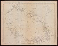
From John Lort Stokes's Discoveries in Australia (1846)., Lower left-hand corner: :Captn Stokes' considers the meridians marked in this Chart to be 2' too far W.", Relief shown by hachures; depth by bathymetric soundings., and Top right-hand corner: "C. Howe bears N. 36* E (Mag) 170 miles from Kent Group."
Publisher:
Pubd ... by John Arrowsmith, 10 Soho Square,
Subject (Geographic):
Bass Strait (Tas. and Vic.)--Discovery and exploration--Maps. and Bass Strait (Tas. and Vic.)--Maps.
Subject (Name):
Arrowsmith, John, 1790-1873, publisher, Beagle (Ship), and Stokes, John Lort, 1811-1885. Discoveries in Australia.
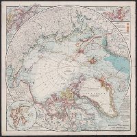
15 linen backed panels, 2 with marbled covers., Contains view : Wrangell Land., Selective relief shown by hachures and spot heights., and Shows destinations and some routes of arctic explorers 1553-1879.
Map showing the route by road & navigation for connecting the Atlantic and Pacific Oceans
Description:
"Statement of distances by land and water, respectively, between Thunder Bay, Lake Superior, and Fort Langley, on Frazer's River.", From the Richard H. Rickard Papers., From: Report on the Exploration of the Country between Lake Superior and the Red River Settlement ... By S.J. Dawson, 1859., and Relief shown by hachures.
Publisher:
J. Ellis,
Subject (Geographic):
Canada and Canada--Discovery and exploration--Maps.
Subject (Name):
Dawson, S. J. (Simon James), 1820-1902. Report on the Exploration of the Country between Lake Superior and the Red River Settlement. and Rickard, Richard H.,---1885--Ownership.
Coordinates not present on map and are approximated., Map of Champion Bay region (now Geraldton) in Western Australia, showing coastal soundings and topography of an area of approx. 250 square miles inland and south to Wizard Peak, centring on Mt. Fairfax. Shows Captain Grey's track and Captain Stokes' track. Relief shown by hachures and spot heights. Depths by soundings., and Originally published in: Discoveries in Australia : with an account of the coasts and rivers explored and surveyed during the voyage of H.M.S. Beagle in the years 1837-43 ... Volume 2 / J. Lort Stokes.
Publisher:
J. Arrowsmith,
Subject (Geographic):
Champion Bay (W.A.)--Maps., Geraldton Region (W.A.)--Discovery and exploration--Maps., and Western Australia--Geraldton Region
Subject (Name):
Beagle (Ship), Grey, George,--1812-1898, Grey, George,--1812-1898--Travel--Australia--Western Australia--Maps., Stokes, John Lort, 1811-1885. Discoveries in Australia., and Stokes, John Lort,--1811-1885--Travel--Australia--Western Australia--Maps.
Subject (Topic):
Discoveries in geography, Nautical charts--Australia--Champion Bay (W.A.), and Voyages and travels
The generall historie of Virginia, New-England, and the Summer Iles : with the names of the
Image Count:
1
Abstract:
Inset depicting Powhatan.
Description:
Between p. 40-41. and Teaching resource: Professor John Mack Faragher, History 141: The American West.
Subject (Geographic):
Virginia --Maps --Early works to 1800
Subject (Topic):
Discoveries in geography, First contact of aboriginal peoples with Westerners, Indians of North America --Virginia --Early works to 1800, and Voyages and travels
Collection Created:
London : Printed by I.[ohn] D.[awson] and I.[ohn] H.[aviland] for Michael Sparkes, 1625