Centennial Exhibition (1876 : Philadelphia, Pa.) Leslie, Frank, 1821-1880 Norton, Frank H. (Frank Henry), 1836-1921
Published / Created:
1877
Call Number:
2006 Folio 202
Image Count:
2
Abstract:
Plates: Flags of all nations, section 1 -- Flags of all nations, section 2 -- Flags of all nations, section 3 -- Declaration of Independence (double-page facsimile) -- Bird's-eye view of the city of Philadelphia (folded plate).
Alternative Title:
Frank Leslie's illustrated historical register of the Centennial exposition, 1876, Historical register of the United States Centennial exposition, 1876, and Illustrated historical register of the Centennial exposition, 1876
Description:
Added illustrated title page: Frank Leslie's illustrated historical register of the Centennial exposition, 1876. Three columns to the page. and Imperfect: 3 plates wanting (Flags of all nations, section 1; Flags of all nations, section 2; and Declaration of Independence). Contains 2 copies of plate ""Flag of all nations, section 3."" Plate ""Bird's-eye view of the city of Philadelphia"" bound at front. Bookplate: Lynn Public Library. Stamp: Lynn Free Public Library. From the library of Alfred Heller.
Publisher:
Frank Leslie's Pub. House,
Subject (Name):
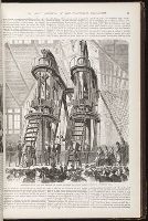
Centennial Exhibition (1876 : Philadelphia, Pa.), Corliss, George H. (George Henry), 1817-1888, Grant, U. S. (Ulysses S.), 1881-1968, and Pedro II, Emperor of Brazil, 1825-1891
Subject (Topic):
Corliss steam-engine., Exhibitions., Steam-engines, and Worlds fairs--Pennsylvania--Philadelphia--1876
From The Gentleman's magazine and historical chronicle (November, 1776), vol. 46., Prime meridian: London., Relief shown pictorially., Sheet measures 21.2 x 25 cm. Cross Collection no. 199., and Shows Fairfield, New Haven, and New London counties in Connecticut, towns, roads, rivers, and place names in Connecticut, Rhode Island and part of Long Island. Includes copper mine near Simsbury, Conn. Also shows relief.
Publisher:
Gentleman's Magazine,
Subject (Geographic):
Connecticut--Maps--Early works to 1800, Long Island Sound (N.Y. and Conn.)--Maps--Early works to 1800, and Rhode Island--Maps--Early works to 1800
From The Gentleman's magazine and historical chronicle (November, 1776), vol. 46., Prime meridian: London., Relief shown pictorially., Sheet measures 22.2 x 26.3 cm. Cross Collection no. 200., and Shows Fairfield, New Haven, and New London counties in Connecticut, towns, roads, rivers, and place names in Connecticut, Rhode Island and part of Long Island. Includes copper mine near Simsbury, Conn. Also shows relief.
Publisher:
Gentleman's Magazine,
Subject (Geographic):
Connecticut--Maps--Early works to 1800, Long Island Sound (N.Y. and Conn.)--Maps--Early works to 1800, and Rhode Island--Maps--Early works to 1800
Although the map bears the date of 1755, it was not published until 1769., Dutch edition of Palairet's Carte des possessions angloises & francoises ... [1755]., From Isaak Tirion, and Hand col. Sheet measures 44 x 54 cm. Accompanied by ms. note by Henry Stevens.
Publisher:
By Isaak Tirion,
Subject (Geographic):
North America--Maps--Early works to 1800 and United States--History--French and Indian War, 1755-1763--Maps--Early works to 1800
Subject (Name):
Palairet, Jean, 1697-1774. Carte des possessions angloises & francoises du continent de l'Amerique Septentrionale
Subject (Topic):
British--America--Maps--Early works to 1800 and French--America--Maps--Early works to 1800
755 1755Z: Hand col. Sheet measures 44 x 54 cm., Although the map bears the date of 1755, it was not published until 1769., Dutch edition of Palairet's Carte des possessions angl, and Hand col. Sheet measures 44 x 54 cm. Accompanied by ms. note by Henry Stevens.
Publisher:
By Isaak Tirion,
Subject (Geographic):
North America--Maps--Early works to 1800 and United States--History--French and Indian War, 1755-1763--Maps--Early works to 1800
Subject (Name):
Palairet, Jean, 1697-1774. Carte des possessions angloises & francoises du continent de l'Amerique Septentrionale
Subject (Topic):
British--America--Maps--Early works to 1800 and French--America--Maps--Early works to 1800