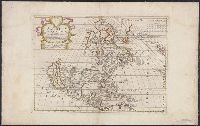
Imperfect; chipped along edges, with some loss of text. Manuscript number "j20" in upper right corner. Left side of Matthaeus Seutter map "Le pays de Perou et Chili ..." pasted onto verso., Includes five bar scales., and Relief shown pictorially.
Publisher:
Venalis prostat Augustae Vindel. apud Ieremiam Wolff,
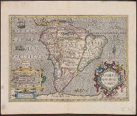
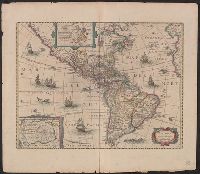
Bar scales given in "leucae Hispanicae" and "milliaria German.", From Gerard Mercator's Atlas ... Amsterdami : Sumptibus & typis aenis Henrici Hondij, 1630., In Latin on verso, with caption title "America Meridionalis," paginated 389-388, with signature 8Q., Inset bird's-eye view of Cuzco with title "Cusco metropolis Peru.", and Relief shown pictorially.
Publisher:
Henrik Hondius,
Subject (Geographic):
Cuzco (Peru)--Aerial views--Early works to 1800 and South America--Maps--Early works to 1800
Subject (Name):
Hondius, Hendrik, 1597-1651 and Mercator, Gerhard, 1512-1594. Atlas
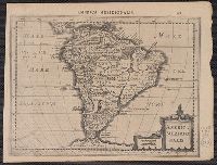
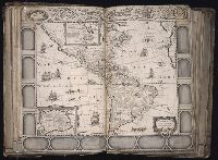
Bar scales given in "leucae Hispanicae" and "milliaria German.", Cross Collection no. 319., From Gerard Mercator's Atlas, 1632., In Latin on verso, with caption title "America Meridionali"; paginated 741 on recto, 742 on verso., and Relief shown pictorially.
Publisher:
Jan Evertsz. Cloppenburch,
Subject (Geographic):
South America--Maps--Early works to 1800
Subject (Name):
Cloppenburch, Jan Evertsz. (Jan Evertszoon), 1571-1648 and Mercator, Gerhard, 1512-1594. Atlas
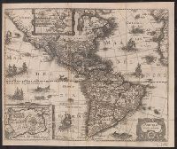
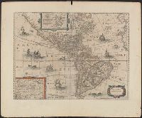
After the J. Hondius map of 1630; reduced, without the decorative border., From Johann Ludwig Gottried's Newe Welt und americanische Historien. [Frankfurt : Mattaeus Merian], 1631., Includes insets of Greenland and Antarctica and illustrations., and Mounted on linen. Sheet measures 38.7 x 46.3 cm. Cross Collection no. 116.
Publisher:
Mattaeus Merian,
Subject (Geographic):
America--Maps--Early works to 1800
Subject (Name):
Bry, Theodor de, 1528-1598, Gottfried, Johann Ludwig, 17th cent. Newe Welt, and Merian, Matthaeus, 1593-1650
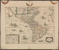
Appears in various eds. of Jan Jansson's Nouvel atlas., French text on verso., Includes ill. of ships and sea monsters, and insets showing "Polus Arcticus" region and "Terra Australis inc, and Sheet measures 50 x 59 cm. Stamp on verso: Yale, Horace Brown, 1900S.
From Janssonius's and Hondius's Atlas novus ... Amstelodami : Apud Ionnem Ianssonium & Henricum Hondium, 1638., Hand col. Sheet measures 50.7 x 58.1 cm. Cross Collection no. 117., Latin text on verso., and Two polar insets.
Publisher:
Henry Hondius,
Subject (Geographic):
Western Hemisphere--Maps--Early works to 1800
Subject (Name):
Hondius, Hendrik, 1597-1651. Atlas novus and Jansson, Jan, 1588-1664. Atlas novus
[Atlas factice of 96 maps by Blaeu, Visscher, Jansson, Hondius and others]
Image Count:
1
Description:
Imperfect: torn along fold, with some loss of text; portions of decorative border [six lower views of American settlements and all vignettes of Native Americans] cut or torn and repaired, with missing sections replicated in ms.; tears repaired. Sheet measures 45.7 x 54.6 cm. No. 22 of 92 maps bound together.
Publisher:
Jodocus Hondius
Subject (Geographic):
America --Maps --Early works to 1800, Antarctica --Maps --Early works to 1800, and Arctic regions --Maps --Early works to 1800
Appears in various eds. of Jansson's Nieuwen atlas., Dutch text on verso., Includes ill. of ships and sea monsters, and insets showing "Polus Arcticus" region and "Terra Australis incognita.", Relief shown pictorially., and Sheet measures 50.1 x 60.9 cm.
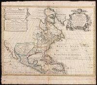
Includes five bar scales., Relief shown pictorially., and Watermark. Manuscript number in upper right corner: jj5. Reinforced at bottom with paper. From the Karpinski Collection.
Publisher:
Venalis prostat Augustae Vindelic apud Jeremiam Wolff,
Subject (Geographic):
North America--Maps.
Subject (Name):
Karpinski, Louis Charles,--1878-1956--Ownership. and Wolf, Jeremias, 1663?-1724, pulbisher.