"Imaginary plan of ancient Jerusalem within the outer wall oriented to the north"--Laor, E. Maps of the Holy Land., Has watermark., and Relief shown pictorially.
Publisher:
Printed for Ric. Chiswell,
Subject (Geographic):
Jerusalem--History--Maps and Jerusalem--Maps--Early works to 1800
Subject (Name):
Chiswell, Richard, Lightfoot, John, 1602-1675, and Lightfoot, John, 1602-1675. Works of the Reverend and learned John Lightfoot
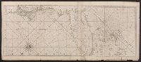
Peninsula and Gulf of Florida or Channel of Bahama with the Bahama Islands
Description:
"DG.4.", From Jefferys's The American atlas ... London : Printed and sold by R. Sayer and J. Bennett, 1776., Hand colored., and Relief shown pictorially. Soundings shown in fathoms. "The soundings along the Florida coast, shoals, islands, and reefs are in feet."
Publisher:
Printed for Robt. Sayer, map and printseller ...,
Subject (Geographic):
Bahamas--Maps--Early works to 1800, Gulf Coast (Fla.)--Maps--Early works to 1800, and Gulf Coast (La.)--Maps--Early works to 1800
Subject (Name):
Jefferys, Thomas, d. 1771. American atlas and Sayer, Robert, 1725-1794
Peninsula and Gulf of Florida or Channel of Bahama with the Bahama Islands
Description:
"DG.4.", From Jefferys's The American atlas ... London : Printed and sold by R. Sayer and J. Bennett, 1776., Pictorial map, and Relief shown pictorially. Soundings shown in fathoms. "The soundings along the Florida coast, shoals, islands, and reefs are in feet."
Publisher:
Printed for Robt. Sayer, map and printseller ...,
Subject (Geographic):
Bahamas--Maps--Early works to 1800, Gulf Coast (Fla.)--Maps--Early works to 1800, and Gulf Coast (La.)--Maps--Early works to 1800
Subject (Name):
Jefferys, Thomas, d. 1771. American atlas and Sayer, Robert, 1725-1794
Peninsula and Gulf of Florida or Channel of Bahama with the Bahama Islands.
Description:
From Jefferys's The American atlas ... London : Printed and sold by R. Sayer and J. Bennett, 1776., Imperfect: detached along folds, with no loss of text. Sheets pasted together to form 1 sheet. Sheets measure 54 x 64 cm. and 54 x 66 cm., and Pictorial map.
Publisher:
Printed for Robt. Sayer, map and printseller ...,
Subject (Geographic):
Bahamas--Maps--Early works to 1800, Gulf Coast (Fla.)--Maps--Early works to 1800, and Gulf Coast (La.)--Maps--Early works to 1800
Subject (Name):
Jefferys, Thomas, d. 1771. American atlas and Sayer, Robert, 1725-1794
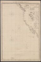
Atlas des Indes Occidentales. and The North American pilot.
Description:
From: The North American pilot. London, 1778-1779. Vol. 2, no. 13., Imperfect: chipped and torn, with no loss of text. Joined with Jeffrey's Island of Cuba with part of the Bahama banks & the Martyrs., Prime meridians: Ferro and London, Relief shown pictorially. Depths shown pictorially and by soundings., and Shows soundings, shoals and sailing channels.
Publisher:
Printed for Robt. Sayer, map & printseller, no. 53 Fleet Street, as the act directs,
Subject (Geographic):
Mexico, Gulf of--Maps--Early works to 1800, Yucatán Channel--Maps--Early works to 1800, and Yucatán Peninsula--Maps--Early works to 1800
Subject (Name):
Sayer, Robert, 1725-1794, publisher
Subject (Topic):
Nautical charts--Mexico, Gulf of--Early works to 1800 and Nautical charts--Yucatán Channel--Early works to 1800
Includes insets of "Victoria Harbour, Vancouver Island," [Map of Mouth of Columbia River], "The harbour of San Francisco / surveyed by Captn. F.W. Beechey, 1828," and "Guaymas Harbour (Gulf of California)." and Relief shown by hachures. Depths shown by soundings.