Busch, Georg Paul, d. 1756, engraver Cóvens et Mortier, printer Gundling, Jacob Paul, Freiherr von, 1673-1731 L'Isle, Guillaume de, 1675-1726. Atlas nouveau
Published / Created:
[1742]
Call Number:
1977 Folio 177
Image Count:
2
Resource Type:
Maps, Atlases & Globes
Alternative Title:
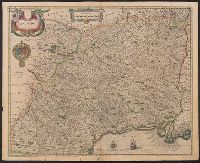
Nova Electoratus Brandenburgici tabula edita per I.P. Fr. von Gundling
Description:
"G.P. Busch sculpsit"., From Guillaume de L'Isle's Atlas nouveau., Includes illustrated cartouches., Prime meridian: Ferro., Relief shown pictorially., Shows settlements, universities, roads, forests, rivers, etc., and Title in ms. on verso. Stamp on verso: 305. Sheet measures 54.2 x 67.5 cm. No. 28 of 34 maps bound together.
Publisher:
Bey Johannes Covens und Cornelius Mortier,
Subject (Geographic):
Brandenburg (Germany)--Maps--Early works to 1800 and Poland--Maps--Early works to 1800
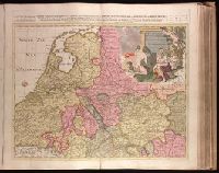
Table geographique dans la quelle fort distinctement, est montré la Partie Meridionale ou Superieure du Rhein, Meuse, Moselle and Table geographique dans la quelle fort distinctement, est montré la Partie Septentrionale ou Inferieure du Rhein, Meuse et Moselle
Description:
Appeared in Peter Schenk's Atlas contractus [ca. 1700]., Backed with paper. Ms. no. "30" in upper right-hand corner or north sheet; ms. no. "31" in upper right-hand corner or south sheet. No. 30 of 87 maps bound together., Includes 6 bar scales., Prime meridan: Ferro., Relief shown pictorially., and Watermarks.
Publisher:
Chez Pierre Schenk ...,
Subject (Geographic):
Rhine River--Maps--Early works to 1800.
Subject (Name):
Schenk, Peter, 1660-1718 or 1719. Atlas contractus.