The military tract comprised 28 townships (1,680,000 acres) in New York State that was granted to soldiers of the War of American Revolution. This land included all or parts of present day Cayuga, Cortland, Onondaga, Oswego, Schuyler, Seneca, Tompkins, and Wayne counties. The names of the towns were given classical Greek and Roman names along a few honoring English authors.
Description:
Heavily annotated throughout by Elkanah Watson., Maps most likely date from 1793 to 1794., and Title devised by cataloger.
Subject (Geographic):
New York (State)--Maps--Early works to 1800. and New York (State)--Surveys--Early works to 1800.
Subject (Name):
Watson, Elkanah,--1758-1842--Ms. notes.
Subject (Topic):
Land subdivision--New York (State)--Early works to 1800.
An issue of the Pownall map of North America and the West Indies; appears similar to the 1783 and 1794 editions., Insets: A particular map of Baffin and Hudson's Bay -- The passage by land to California., Prime meridians: London and Ferro., and Relief shown pict
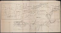
Includes ancillary maps detailed connecting lines of Illinois Central RR, railways and ferries centering aorund Rock Island, Illinois, and profile map of bridge crossing Mississipp River between Davenport, Iowa and Rock Island, Illinois. and Shows railroad li