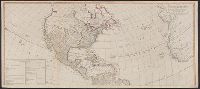
"Publish'd by Laurie & Whittle, No. 53 Fleet Street, as the Act directs, 12th May 1794.", Appears in Thomas Kitchin's General atlas, describing the whole universe., Includes table, "The Continent and Islands of America are Divided and Possessed as follows viz.", Inset: The supplement to North America containing the countries adjoining to Baffins & Hudson bays., Joined into two sheets measuring 53.8 x 121.6 cm. and 53.8 x 121.2 cm. Stamped number on top sheet: 60. Stamped number on top sheet: 61. Cross Collection no. 139., Prime meridian: Ferro., Re-issue of John Gibson's map of [1763], 1772, 1777, 1783, and 1786., Relief shown pictorially., Shows the Western Hemisphere with some political borders, tabular information indicates national possessions; cities and rivers., and Title from ornamental cartouche.
Publisher:
Laurie & Whittle,
Subject (Geographic):
America--Maps--Early works to 1800 and West Indies--Maps--Early works to 1800
Subject (Name):
Gibson, J. (John), Kitchin, Thomas, d. 1784. General atlas describing the whole universe, Pownall, Thomas, 1722-1805, and Robert Laurie and James Whittle
"Publish'd by Laurie & Whittle, No. 53 Fleet Street, as the Act directs, 12th May 1794.", Appears in Thomas Kitchin's General atlas, describing the whole universe., Copy 2: Joined into two sheets measuring 53.7 x 125.6 cm. and 53.7 x 125.6 cm. Stamped number on sheets: 34. Franklin Collection no. 131 1794 11-12., Includes table, "The Continent and Islands of America are Divided and Possessed as follows viz.", Inset: The supplement to North America containing the countries adjoining to Baffins & Hudson bays., Prime meridian: Ferro., Re-issue of John Gibson's map of [1763], 1772, 1777, 1783, and 1786., Relief shown pictorially., Shows the Western Hemisphere with some political borders, tabular information indicates national possessions; cities and rivers., and Title from ornamental cartouche.
Publisher:
Laurie & Whittle,
Subject (Geographic):
America--Maps--Early works to 1800 and West Indies--Maps--Early works to 1800
Subject (Name):
Gibson, J. (John), Kitchin, Thomas, d. 1784. General atlas describing the whole universe, Pownall, Thomas, 1722-1805, and Robert Laurie and James Whittle
"Publish'd by Laurie & Whittle, No. 53 Fleet Street, as the Act directs, 12th May 1794.", Appears in Thomas Kitchin's General atlas, describing the whole universe., Copy 3: Joined into two sheets measuring 54.7 x 123.5 cm. and 54.6 x 123.4 cm. Stamped number on top sheet: 32. Stamped number on top sheet: 33. Franklin Collection no. 131 1794 13-14., Includes table, "The Continent and Islands of America are Divided and Possessed as follows viz.", Inset: The supplement to North America containing the countries adjoining to Baffins & Hudson bays., Prime meridian: Ferro., Re-issue of John Gibson's map of [1763], 1772, 1777, 1783, and 1786., Relief shown pictorially., Shows the Western Hemisphere with some political borders, tabular information indicates national possessions; cities and rivers., and Title from ornamental cartouche.
Publisher:
Laurie & Whittle,
Subject (Geographic):
America--Maps--Early works to 1800 and West Indies--Maps--Early works to 1800
Subject (Name):
Gibson, J. (John), Kitchin, Thomas, d. 1784. General atlas describing the whole universe, Pownall, Thomas, 1722-1805, and Robert Laurie and James Whittle
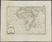
"This map is copied from an original drawn by Monsr. D'Anv, Also appeared in Kitchin's General atlas describing the whole universe. London : Printed for Robert Sayer, [1780]., Prime meridians: Ferro and London., and Relief shown pictorially; depths by soundings.
Publisher:
Printed for Robert Sayer,
Subject (Geographic):
Africa, West--Maps--Early works to 1800
Subject (Name):
Abbot, Charles,--Baron Colchester,--1757-1829--Bookplate, Anville, Jean Baptiste Bourguignon d', 1697-1782, Kitchin, Thomas, d. 1784. General atlas describing the whole universe, and Robert Laurie and James Whittle