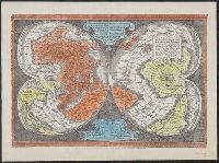
"Ne que ad nos Fram orbis ... Cappadocie 7.", "Quam hic vides orbis imagine lector cadide ... Vale 1538", Cordiform map of the world, 1538, Joanni Drosio suo Gerardus Rupelmudan deducabat., Map of the world, 1538, Orbis imago., and World map on double cordiform pro
Description:
Also known as World map on double cordiform projection and Orbis imago., Cross collection no. 4., Facsimile of Gerhard Mercator's first world map, published in Louvain, 1538., Relief shown pictorially., and Title from another facsimile published by the New York Public Library.
Publisher:
Julius Bien & Co., photo-lith,
Subject (Name):
Brevoort, James Carson, 1818-1887 and Julius Bien & Co
Subject (Topic):
Early maps--Facsimiles and World maps--Early works to 1800--Facsimiles
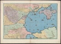
Eigentliche vnd warhafftige Beschreibung / der wunderbaerlichen Schiffarth (der Hollaender
Image Count:
1
Description:
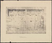
Map has small brown mark on both the recto and verso at the bottom of the map frame below and to the left of the word "Linie"., Map has small water stain on both the recto and verso in the lower right corner of the page that meets with the gutter., Printed above map in center of page: Fol. 73., and Scale [ca. 1:6,500,000].
Subject (Geographic):
Borneo --Maps --Early works to 1800
Collection Created:
Gedruckt zu Amsterdam / Durch Cornelium Nicolaum / Anno 1602
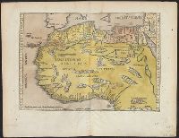
Cross Collection no. 60., From Janssonius's Niewen atlas ... Amstelodami : Apud Ioannem Ianssonium, 1652., Hand col. Mounted on linen., Includes marginal ill., Relief shown pictorially., Title supplied by cataloger., and Variant of Hondius' Polus Antarcticus, 1638.
Publisher:
J. Jansson,
Subject (Geographic):
Antarctica--Maps--Early works to 1800 and Southern Hemisphere--Maps--Early works to 1800