Kaerte van de rivieren van London en Rochester of Chetham
Description:
Includes inset of Medway River below Rochester, ill., and text., Relief shown pictorially., and Shows approach to England of the Dutch fleet commanded by De Ruyter on 19-23 June 1667, during the second Anglo-Dutch war.
Publisher:
Nicolaes Visscher, in de Kalverstraet, in de Visscher,
Subject (Geographic):
Medway, River (England)--Maps--Early works to 1800 and Thames Valley (England)--Maps--Early works to 1800
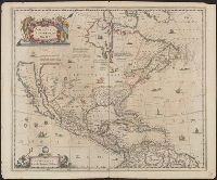
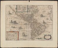
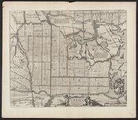
Covers North America, Cent, Dutch text on verso, with signature "Bb.", Relief shown pictorially., and State 2, first issued in 1641, according to Burden; matches description of Dutch text versions appearing in Nieuwen atlas editions 1645, '47, '52, '53, and '58.
Appears in various eds. of Jansson's Nieuwen atlas., Dutch text on verso., Includes ill. of ships and sea monsters, and insets showing "Polus Arcticus" region and "Terra Australis incognita.", Relief shown pictorially., and Sheet measures 50.1 x 60.9 cm.
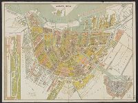
Inzet: [1.] Vondels park ; [2.] Plan van uitbreiding der stad, vastgesteld in 1874., Verso: Gids voor de bezoekers van Amsterdam., and Verso: Lijst van straten, grachten enz.
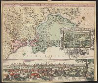
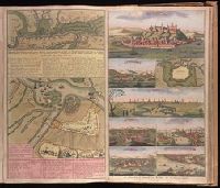
Accurate aftekening hoe de twee Legers geleegen hebben voor Belgrado, ent bomberderen en kanonneeren op malkanderen van den 2 tot den 14 Augustus anno 1717 and Nieuwe accurate kaart van de marse der Keyserlyke armee van Peter Wardien en Futak.
Description:
Backed with paper. Ms. no. in upper right corner [illegible due to trimming]. Sheet measures 53.8 x 62.4 cm. No. 74 of 87 maps bound together., On sheet with 1 other map ("Nieuwe accurate kaart van de marse der Keyserlyke armee van Peter Wardien en Futak ... tot voor Belgrado ... 9 tot den 19 Iuny anno 1717") and 7 bird's-eye views ("Belgrad," "Temeswar" [with map "De Stadt Temeswar"], "Temeswar" [2], "Wardien," "Offen v. Pest," "Sigeth," and "Citta e porto di Constantinopoli")., Relief shown pictorially., and With inset bird's-eye view of Belgrade in upper left corner.
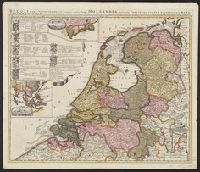
"Cum privil.", Appears in Schenk's Atlas contractus ... [Amsterdam : Peter Schenk, ca. 1700]., Imperfect: Mutilated, with some loss of text. Sheet measures 53.5 x 62 cm. Verso: "19" (?) in ink ms., Insets: Batavorum colon, and Relief shown pictorially.
Publisher:
Peter Schenk?
Subject (Geographic):
East Indies--Maps--Early works to 1800, Netherlands--Maps--Early works to 1800, and New Netherland--Maps--Early works to 1800