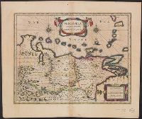
Bar scales in "Milliaria Germanica communia" and "Milliaria Gallica communia.", From Willem and Joan Blaeu's Le theatre du monde ... Amsterdami : Apud Guiljelmum et Iohannem Blaeu, 1635., Relief shown pictorially., and Text in French on verso, with caption title "Venezuela, &c." and signature 7F.
Publisher:
Guiljelmus Blaeuw excudit,
Subject (Geographic):
Venezuela--Maps--Early works to 1800
Subject (Name):
Blaeu, Joan, 1596-1673. Theatrum orbis terrarum. French and Blaeu, Willem Janszoon, 1571-1638. Theatrum orbis terrarum. French
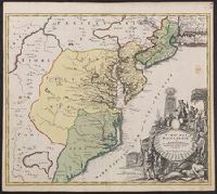
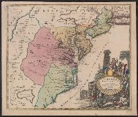
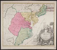
Also covers Delaware, southern Pennsylvania, New Jersey, western Long Island, southwestern Connecticut, and portions of adjacent areas., Bar scale given in "milliaria Germanica"., First appe, Includes ill., and Relief shown pictorially. Depths shown by soundings.
Also covers Delaware, southern Pennsylvania, New Jersey, western Long Island, southwestern Connecticut, and portions of adjacent areas., Bar scale given in "milliaria Germanica"., Includes ill., Relief shown pictorially. Depths shown by soundings., and Title in L
Also covers Delaware, southern Pennsylvania, New Jersey, western Long Island, southwestern Connecticut, and portions of adjacent areas., Bar scale given in "milliaria Germanica"., Includes ill., Prime meri, and Relief shown pictorially. Depths shown by soundings.
"Cum privilegio sac. caes. majest.", Also covers Delaware, southern P, Annotated "Quacker" near Philadelphia in red ink, and "100" in black ink on verso., Prime meridian: Ferro., Title in Latin. Place names in Latin, English, and French., and Watermark.
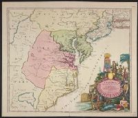
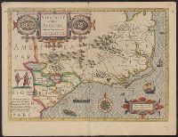
Appears in French eds. of Gerhard Mercator's Atlas (1628 and 1635)., Includes notes, col. ill., and cartouche with a view of a Florida Indian village on the left and a Virginia Indian village on the right., Relief shown pictorially., and Sheet measure
Publisher:
Hendrik Hondius,
Subject (Geographic):
Florida--Maps--Early works to 1800, South Atlantic States--Maps--Early works to 1800, and Virginia--Maps--Early works to 1800
Subject (Name):
Hondius, Hendrik, 1597-1651 and Mercator, Gerhard, 1512-1594. Atlas. French
From the Collection: Hanbury-Williams, Charles, 1708-1759
Published / Created:
1717–1719
Call Number:
LWL MSS 7
Container / Volume:
box 52, folder 25
Image Count:
84
Description:
Charles Williams was a native of Caerleon, and had a successful career in Smyrna when he fled Wales after killing his cousin in a duel. He returned to London as a financier in the 1690s and befriended John Hanbury. When he died in 1720 he left his estate to Hanbury, who entailed it for his son Charles, who then took the name Hanbury-Williams. For further information, see The Hanburys of Monmouthshire by Richard Hanbury Tenison (1995), chapter 4. and A volume of letters bound in gold-tooled and stamped green vellum, with a printed CH-W number label (and evidence of a Phillipps label, now missing) on the spine. The Hanbury-Williams volume number is 46; the Phillipps number is 10893.
All volumes bound to match 1973 Folio 72. Factitious collection of about 549 maps taken from the atlases of the 17th and the beginning of the 18th cent., put together with the title "Atlas" and bound in 6 volumes. These volumes originally bore the imprint: Amstelaedamii apvd Reiniervm & Josvam Ottens. Over these words on the title-pages of v. 1-2, 4-6 is the name of Henrik de Leth who painted them. Volume 3 has only the erased imprint of Ottens., For fuller description see Phillips 3448 and C. Koeman's Atlantes Neerlandici, bibliography of terrestrial, maritime and celestial atlases and pilot books, published in the Netherlands up to 1800, Amsterdam c1967-71, v. 2, p. 63-83., and Maps by P. Schenck and son, G. Valck, F. de Wit, N. Visscher and others.
Publisher:
chez J. Covens & C. Mortier,
Subject (Geographic):
Denmark --Maps --Early works to 1800
Subject (Name):
Reiner et Josua Ottens (Firm), Schenk, Peter, 1660-1718 or 1719., and Valck, G. (Gerard), 1651 or 1652-1726.