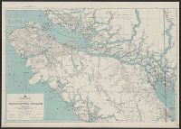
AMS ; A521 and Series (Standard map series designation system) ; A521.
Description:
Map originallly published by British Columbia Dept. of Lands., Northerly portion Vancouver Island, 1929, Map No. 2C -- Southerly portion Vancouver Island, 1938, Map No. 2A., Relief shown by s, and South sheet contains index map, location map, and mileage charts.
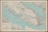
AMS ; A521, Northerly portion Vancouver Island, Series (Standard map series designation system) ; A521., and Southerly portion Vancouver Island
Description:
Map originallly published by B, North sheet contains inset of the Scott Islands., Northerly portion Vancouver Island, 1929, Map No. 2C -- Southerly portion Vancouver Island, 1938, Map No. 2A., and South sheet contains index map, location map, and mileage charts.