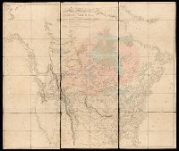
BEIN 71 1820B: Dissected and mounted on linen., Relief shown by hachures., "Additions to 1814" underneath "humble" in title., and "Additions to 1802" follows publication statement at bottom of map.
Publisher:
Published Jan. 1, 1795 by A. Arrowsmith, No. 10 Soho Square
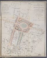
This plan shows the intention to remove Bethlem ('Bedlam") Hospital and replace it with the 'London Amphitheatre' which would comprise at least 60 houses with gardens, stables and coach-houses suitable for 'Opulent Citizens'. This complex will be linked directly to the Royal Exchange via a 80-ft wide new street
Description:
Colored for reference with an explanation note at upper left. Following imprint beneath map: Price one shilling., Shows George Dance's scheme for the reconstruction of streets from the Bank north to Finsbury Square. The designs were only partly carried out. The 'London Amphitheatre' on the site of Bethlehem Hospital was built as Finsbury Circus in about 1812., Sheet trimmed to 37 x 30.8 cm, resulting in partial loss of imprint and price statement beneath map., and Tipped in opposite page 396 in volume 1 of an extra-illustrated copy of: Malcolm, J.P. Londinium redivivum, or, An antient history and modern description of London.
Publisher:
Engrav'd & publish'd by John Luffman, No. 28, Little Bell Alley, Coleman Street
Subject (Geographic):
England, London, City of London (England), London (England), City of London., and London.
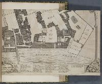
Survey and ground plot of the Royal Palace of White Hall
Description:
Map of the Palace of Whitehall, showing the various rooms, courts, gardens, wharves, barracks and the park beyond, the river to the south. An elegant border formed of pillars with scrolling capitals and two keys to the map. Inset maps to the upper left and right of Charing Cross and Whitehall respectively. A further key below and a descriptive text on a book to the upper left., The title on a banner above between three armorials., A scale on the pillar to the left., Imperfect; only lower right quadrant is present (sheet 22.5 x 34.2 cm), with the rest of the map trimmed away., Folded to 22.5 x 17.4 cm; mounted to 27.1 x 21.3 cm., and Mounted after page 278 in volume 4 part 1 of an extra-illustrated copy of: Malcolm, J.P. Londinium redivivum, or, An antient history and modern description of London.
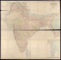
BEIN Covers 59 +1882: Dissected and mounted on linen., Relief shown by hachures., "Published by Wm. Allen & Co., April 3rd, 1870, corrections to 1882.", and Inset: Continuation of British Burmah.
Publisher:
W.H. Allen & Co.
Subject (Geographic):
South Asia, India, Nepal, Bhutan, Bangladesh, and Burma