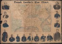
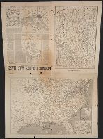
"Drawn on wood by G. W. Colton.", Insets: Vicinity of Washington City, D.C.; Southern portio, Mounted on linen. Imperfect: chewed, frayed, mutilated., and Shows locations of battles, positions of Rebel troops, U.S. troops, forts and fortified towns.
Publisher:
Frank Leslie,
Subject (Geographic):
United States--History--Civil War, 1861-1865--Maps and United States--History--Civil War, 1861-1865--Pictorial works
Subject (Name):
Colton, G. Woolworth (George Woolworth), 1827-1901 and Leslie, Frank, 1821-1880
Frank Leslies illustrated newspaper. and War maps and companion to the newspaper
Description:
Map of Savannah, Georgia and its surroundings and Map of the Southern Coast of of the United States from Pensacola to New Orleans showing the strategic position of Ship Island, Mississippi, now occupied by Col. Phelps and the national troops with the approach
Publisher:
Frank Leslie,
Subject (Geographic):
United States--History--Civil War, 1861-1865--Maps and United States--History--Civil War, 1861-1865--Newspapers
Subject (Name):
Colton, G. Woolworth (George Woolworth), 1827-1901
Colton, G. Woolworth (George Woolworth), 1827-1901
Published / Created:
1861
Call Number:
754 1861A
Container / Volume:
BRBL_00416
Image Count:
1
Resource Type:
Maps, Atlases & Globes
Alternative Title:
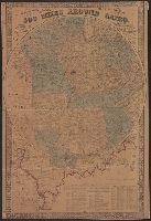
500 miles around Cairo and G. Woolworth Colton's map of the country five hundred miles around Cairo
Description:
General map centered on Cairo, Ill., with five concentric circles at intervals of 100 miles., Includes a list of the "Principle Forts and Military Stations the Western and Gulf states"., and Insets: [Map of Illinois, Missouri, Arkansas Kentucky, Tennessee, Miss
Publisher:
G. Woolworth Colton,
Subject (Geographic):
Illinois--Maps and United States--History--Civil War, 1861-1865--Maps
Colton, G. Woolworth (George Woolworth), 1827-1901
Published / Created:
1862, c1861.
Call Number:
75 1862C
Container / Volume:
BRBL_00403
Image Count:
1
Resource Type:
Maps, Atlases & Globes
Alternative Title:
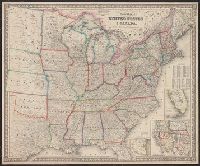
Guide map of the United States & Canada. and New Guide map of the United States & Canada.
Description:
Insets: Plan of the southern portion of Florida.--Western portion of the United States., Prime meridians: Greenwich, Washington., Relief shown by hachures., and Table: Population of the United States.