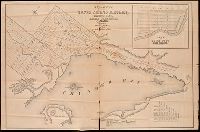
Coordinates not present on map and are approximated., Imperfect: mutilated, with some loss of text. Manuscript annotations on map. Manuscript title on verso: Thunder Bay Silver Mining District. From the Richard H. Rickard Papers., Inset: plan of town plot, Fort William., and Relief shown by hachures.
Publisher:
[publisher not identified],
Subject (Name):
Copp Clark Company and Rickard, Richard H.,---1885--Ownership.
Subject (Topic):
Real property--Ontario--Thunder Bay Region--Maps. and Silver mines and mining--Ontario--Thunder Bay Region--Maps.
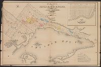
Coordinates not present on map and are approximated., Imperfect. Mutilated with loss of text., Inset: plan of town plot, Fort William., and Relief shown by hachures.
Publisher:
[publisher not identified],
Subject (Name):
Copp Clark Company and Rickard, Richard H.,---1885--Ownership.
Subject (Topic):
Real property--Ontario--Thunder Bay Region--Maps. and Silver mines and mining--Ontario--Thunder Bay Region--Maps.
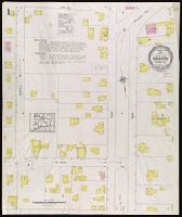
"(2886). (2 sheets).", Contains information on population, prevailing winds, water facilities and fire department., Partial cadastral map., and Sheets disbound. Library of Congress copyright stamp on title sheet.
Subject (Geographic):
Sharon (Conn.)--Maps
Subject (Name):
Library of Congress Stamp
Subject (Topic):
Fire risk assessment--Connecticut--Sharon--Maps and Real property--Connecticut--Sharon--Maps
Fire insurance map, colored to show building construction, property boundaries and house and block numbers.
Alternative Title:
Aug. 1915, Smyrna, Del., Smyrna, Del., and Smyrna, Delaware
Description:
"758 (7 sheets).", Coordinates not present on map and are approximated., Includes index to streets and buildings., Sheet 1 includes key to building colors and other features of construction, water facilities and fire department, index map for the adjoining sheets., and Stamps on sheet 1: CLF 29465; Sep. 14, 1915.
Publisher:
Sanborn Map Company,
Subject (Geographic):
Smyrna (Del.)--Maps.
Subject (Topic):
Fire risk assessment--Delaware--Smyrna--Maps. and Real property--Delaware--Smyrna--Maps.
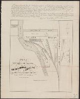
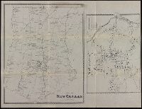
"38" in upper right corner., Coordinates not present on map and are approximated., On sheet with reproduction map "New Canaan ... scale 25 rods to the inch.", Reproduction of original 1867 map published by Beers, Ellis & Soule in their Atlas of New York and vicinity., and Shows residences and magisterial districts.
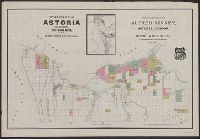
"Entered according to act of Congress in the year 1890 by W.H. Whitney in the office of the Librarian of Congress at Washington.", Cadastral map., Inset: [Mouth of the Columbia River, Oregon and Washington], scale [ca. 1:202,000]., and Map carries the logo of the Union Pacific Railroad.
Publisher:
W.H. Whitney,
Subject (Geographic):
Astoria (Or.)--Maps and Warrenton (Or.)--Maps
Subject (Name):
Everts, L. H. (Louis H.) and Whitney, W. H
Subject (Topic):
Real property--Oregon--Astoria--Maps and Real property--Oregon--Warrenton--Maps