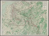
Indicates "Furthest advance of the German Army", and "Battle line May 10th, 1918" overprinted in red., Relief shown by spot heights., and Shows railways, canals, aircraft depots, wireless stations, forts, naval arsenals and boundaries.
Publisher:
C.S. Hammond,
Subject (Geographic):
Europe--Maps
Subject (Topic):
World War, 1914-1918--Campaigns--Europe--Maps and World War, 1914-1918--Campaigns--Western Front--Maps
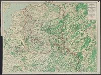
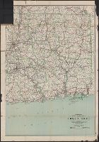
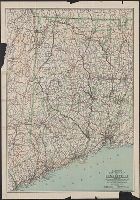
Includes the eastern part of Connecticut from Hartford east to the Rhode Island border. and Indicates best and fair roads, interurban electric railways, and railroads.
Publisher:
C.S. Hammond & Co.,
Subject (Geographic):
Connecticut--Maps
Subject (Name):
Geological Survey (U.S.) and U.S. Coast and Geodetic Survey
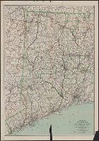
Includes the western part of Connecticut from The New York border to West Hartford and New Britain. and Indicates main auto routes and state improved roads, interurban electric lines, and railroads.
Publisher:
C.S. Hammond & Co.,
Subject (Geographic):
Connecticut--Maps
Subject (Name):
Geological Survey (U.S.) and U.S. Coast and Geodetic Survey
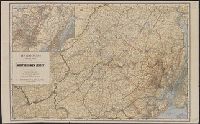
Hammond's road map of New Jersey : and Road map of northern New Jersey
Description:
"Based on the surveys of the United States Geological Survey, United States Coast and, "Showing good roads, fair roads, through automobile routes, etc."--Cover when folded., and Includes enlarged scale inset map of Jersey Cty, Newark, the Oranges and vicinity.
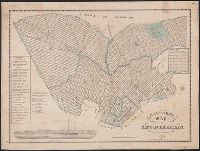
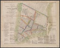
"Entered according to act of Congress, the 27th day of March 1824, by Wm. Hooker of the state of N. York.", Covers Manhattan south of 15th Street on the west side and south of 31st Street on the east side., and Includes lists of distributors, churches, markets,
Publisher:
W. Hooker,
Subject (Geographic):
Manhattan (New York, N.Y.)--Maps, New York (N.Y.)--Administrative and political divisions--Maps., and New York (N.Y.)--Maps