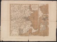
Mer, Printed on sheet with 3 maps total: [1.] The seat of war in New England -- [2.] Plan of Boston Harbour -- [3.] Plan of the town of Boston with the attack on Bunkers-Hill in the peninsula of Charlestown, the 17th of June 1775., and Relief shown by hachures.
Publisher:
Printed for R. Sayer & J. Bennett, No. 53 Fleet Street, as the act directs,
Subject (Geographic):
Boston (Mass.)--History--Siege, 1775-1776--Maps--Early works to 1800, New England--History--Revolution, 1775-1783--Maps--Early works to 1800, New England--Maps--Early works to 1800, and United States--History--Revolution, 1775
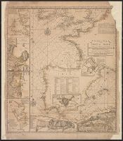
"Emanl. Bowen sculp." and Insets: Plan of the Harbours of Ferrol and the Groyne -- Plan of St Sebastian -- Plan of Barcelona -- Plan of the Bay and City of Cadiz -- Plan of
Publisher:
T. Jefferys,
Subject (Name):
Bowen, Emanuel, d. 1767
Subject (Topic):
Coasts--Europe, Western--Maps--Early works to 1800 and Nautical charts--Europe, Western--Early works to 1800
National Geographic Society (U.S.). Cartographic Section
Published / Created:
1940
Call Number:
7821 1940
Container / Volume:
BRBL_00506
Image Count:
1
Resource Type:
Maps, Atlases & Globes
Description:
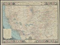
Copyright: The National Geographic Society., Includes index of routes of exploration, text and ill. of notable sites and events, and state seals., Issued with the National geographic magazine, v. 77, no. 6, June 1940., and Relief shown by hachures and spot heigh
Publisher:
The Society,
Subject (Geographic):
Southwest, New--Maps
Subject (Name):
A. Hoen & Co, Brehm, J. J, Chamberlin, Wellman, Darley, James M. (James Morrison), Eastwood, H. E, Holdstock, A. E, and Riddiford, Charles E
National Geographic Society (U.S.). Cartographic Section
Published / Created:
1940
Call Number:
7821 1940
Container / Volume:
BRBL_00506
Image Count:
1
Resource Type:
Maps, Atlases & Globes
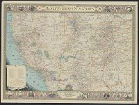
Description:
Copyright: The National Geographic Society., Includes index of routes of exploration, text and ill. of notable sites and events, and state seals., Issued with the National geographic magazine, v. 77, no. 6, June 1940., and Relief shown by hachures and spot heigh
Publisher:
The Society,
Subject (Geographic):
Southwest, New--Maps
Subject (Name):
A. Hoen & Co, Brehm, J. J, Chamberlin, Wellman, Darley, James M. (James Morrison), Eastwood, H. E, Holdstock, A. E, and Riddiford, Charles E
National Geographic Society (U.S.). Cartographic Section
Published / Created:
1940
Call Number:
7821 1940
Container / Volume:
BRBL_00506
Image Count:
1
Resource Type:
Maps, Atlases & Globes
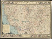
Description:
Copyright: The National Geographic Society., Includes index of routes of exploration, text and ill. of notable sites and events, and state seals., Issued with the National geographic magazine, v. 77, no. 6, June 1940., Mounted on linen., and Relief shown by hachu
Publisher:
The Society,
Subject (Geographic):
Southwest, New--Maps
Subject (Name):
A. Hoen & Co, Brehm, J. J, Chamberlin, Wellman, Darley, James M. (James Morrison), Eastwood, H. E, Holdstock, A. E, and Riddiford, Charles E