This plan of two attempts to arrive at the source of the Nile
Description:
Relief shown pictorially.
Publisher:
s.n.,
Subject (Geographic):
Blue Nile River (Ethiopia and Sudan)--Discovery and exploration--Maps--Early works to 1800 and Ethiopia--Discovery and exploration--Maps--Early works to 1800
Subject (Name):
Barrington, Daines, 1727-1800, Bruce, James,--1730-1794--Travel--Maps--Early works to 1800, and Walker, John, 1786-1873
Insets: Plan of the entrance to Port Manoukao -- Plan of Victoria Bay of Islands New Zealand -- Port Nicholson -- Plan of Dusky Bay -- Plan of Southern Port, Stewarts Island -- -Oyerri or Pelorus River -- Plan of the bar and part of the Hokianga River . and Plan of Port Nicholson and Oyerri by permission of the New Zealand Land Company.
Publisher:
James Wyld, geographer to the Queen, Charing Cross East,
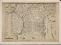
Map of the improved part of the province of Pennsylvania
Description:
2nd state of 2 known states. Distinguishing features of 2nd state: "Four [sic] long lines of text have been added at right of the Narrows of the Susquehannah at Nelson's Ferry. A road now leads east from Carlisle direct to Pine Ford" (Wheat and Brun 89).
Publisher:
sold by the author Nicholas Scull,
Subject (Geographic):
Pennsylvania--Administrative and political divisions--Maps--Early works to 1800 and Pennsylvania--Maps--Early works to 1800
Subject (Name):
Davis, John, fl. 1756-1759, Penn, Richard, 1706-1771. dedication, Penn, Thomas, 1702-1775. dedication, and Turner, James, d. 1759. engraver