
You Searched For
1 - 5 of 5
Search Results
- Creator:
- U.S. Lake Survey
- Published / Created:
- 1945
- Call Number:
- 50 1945
- Container / Volume:
- BRBL_00273
- Image Count:
- 2
- Resource Type:
- Maps, Atlases & Globes
- Alternative Title:
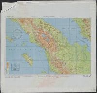
- AAF cloth chart.
- Description:
- "3/45 SS" and "4/45 SS", Cloth maps., Includes sheet index, map "Index to boundaries," and "Conversion table.", and Relief shown by gradient tints and spot heights.
- Publisher:
- Army Map Service,
- Subject (Geographic):
- Indonesia--Maps
- Subject (Name):
- United States. Aeronautical Chart Service and United States. Army Map Service
- Subject (Topic):
- Military maps
- Found in:
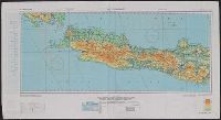
- Beinecke Rare Book and Manuscript Library > AAF cloth chart. No. C-48 West Java / reproduced under the direction of the Commanding General, Army Air Forces for the Aeronautical Chart Service by the Army Map Service, Washington D.C. ; copied by Lake Survey Branch, A.M.S., Detroit, Michigan, July 194
- Creator:
- Great Britain. War Office. General Staff. Geographical Section
- Published / Created:
- 1943
- Call Number:
- 3969 Ib4 1943
- Container / Volume:
- BRBL_00194
- Image Count:
- 1
- Resource Type:
- Maps, Atlases & Globes
- Alternative Title:
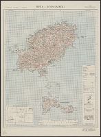
- Great Britain. War Office. General Staff. Geographical Section. G.S.G.S. ; 4376., GSGS (Series) ; 4376., Ibiza and Formentera, and Its [G.S.G.S.] ; 4376
- Description:
- "Contour interval 50 metres.", "N3835-E109 / 35x34.", Five classes of roads and paths, and wooded and intensely culivated areas are shown., In upper margin: Balearic islands 1:100,000 ..., and Insets: Index to adjoining sheets and incidence of grid letters--Relia
- Publisher:
- Army Map Service, U.S. Army,
- Subject (Geographic):
- Formentera (Spain)--Maps and Ibiza (Spain)--Maps
- Subject (Name):
- United States. Army Map Service
- Found in:
- Beinecke Rare Book and Manuscript Library > Ibiza & Formentera [cartographic material].
- Creator:
- Great Britain. War Office. General Staff. Geographical Section
- Published / Created:
- 1943
- Call Number:
- 3969 M52 1943
- Container / Volume:
- BRBL_00194
- Image Count:
- 1
- Resource Type:
- Maps, Atlases & Globes
- Alternative Title:
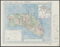
- Great Britain. War Office. General Staff. Geographical Section. G.S.G.S. ; 4134., GSGS (Series) ; 4134., and Its [G.S.G.S.] ; 4134
- Description:
- "Contour interval 50 metres.", "N3945-E345/25x40.", Five classes of roads or paths, three classes of railroads, and areas of woods and intensive culivation are shown., In upper margin: Balearic islands 1:100,000 ..., and Insets: Mahon [with index]--Index to adjoi
- Publisher:
- Army Map Service, U.S. Army,
- Subject (Geographic):
- Minorca (Spain)--Maps
- Subject (Name):
- United States. Army Map Service
- Found in:
- Beinecke Rare Book and Manuscript Library > Menorca [cartographic material].
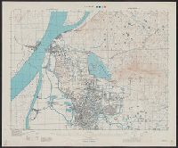
- Creator:
- Great Britain. War Office. General Staff. Geographical Section
- Published / Created:
- 1945
- Call Number:
- 56 N15 1945
- Container / Volume:
- BRBL_00297
- Image Count:
- 1
- Resource Type:
- Maps, Atlases & Globes
- Alternative Title:
- [U.S. Army Map Service. A.M.S. ; L901], GSGS (Series) ; 3831., Its [G.S.G.S.] ; 3831, and Series (Standard map series designation system) ; L901.
- Description:
- "5-45.", "Contour interval 10 metres.", At head of title: China., Four classes of roads and paths are shown; some streets and buildings are named; areas of vegetation and cultivation are shown., and Military grid.
- Publisher:
- Army Map Service,
- Subject (Geographic):
- Nanjing (Jiangsu Sheng, China)--Maps
- Subject (Name):
- United States. Army Map Service
- Found in:
- Beinecke Rare Book and Manuscript Library > Nanking [cartographic material].