
You Searched For
« Previous
| 550 - 555 of 555 |
Next »
Search Results
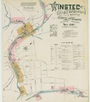
550. Winsted and West Winsted, Connecticut.
- Creator:
- Sanborn Map & Publishing Co., issuing body
- Published / Created:
- 1887
- Call Number:
- 766 W73 1887
- Image Count:
- 6
- Resource Type:
- Maps, Atlases & Globes
- Abstract:
- Sanborn fire insurance maps are a rich source of historic data on the urban built environment of North America during the 19th and early 20th centuries. The atlases were created for the purpose of underwriting fire insurance policies, which depended upon accurate and frequently-updated information about construction materials, municipal and transportation infrastructure, industrial and commercial landuse and more. The Yale University Library Map Department scanned its holdings of Sanborn fire insurance maps (consisting primarily of Connecticut towns) in order to make the maps more accessible.
- Alternative Title:
- Nov. 1887, Winsted, Conn. and W. Winsted
- Description:
- "(2723) 6 sheets.", Contains information on population, prevailing winds, water facilities and fire department., Includes index of streets and specials., Partial cadastral map., and SMLMAPL 766 W73 1887: Sheets disbound. "Triplicate" stamp on sheets. Library of Congress copyright stamp on title sheet.
- Subject (Geographic):
- Winsted (Conn.)--Maps
- Subject (Name):
- Library of Congress Stamp
- Subject (Topic):
- Fire risk assessment--Connecticut--Winsted--Maps and Real property--Connecticut--Winsted--Maps
- Found in:
- Beinecke Rare Book and Manuscript Library > Winsted and West Winsted, Connecticut.
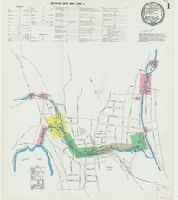
551. Winsted and West Winsted, Connecticut.
- Creator:
- Sanborn-Perris Map Co., issuing body
- Published / Created:
- 1892
- Call Number:
- 766 W73 1892
- Image Count:
- 7
- Resource Type:
- Maps, Atlases & Globes
- Abstract:
- Sanborn fire insurance maps are a rich source of historic data on the urban built environment of North America during the 19th and early 20th centuries. The atlases were created for the purpose of underwriting fire insurance policies, which depended upon accurate and frequently-updated information about construction materials, municipal and transportation infrastructure, industrial and commercial landuse and more. The Yale University Library Map Department scanned its holdings of Sanborn fire insurance maps (consisting primarily of Connecticut towns) in order to make the maps more accessible.
- Alternative Title:
- Oct. 1892, Winsted, Conn. and W. Winsted
- Description:
- "(5755) 7 sheets.", Contains information on population, prevailing winds, water facilities and fire department., Includes index of streets and specials., Partial cadastral map., and SMLMAPL 766 W73 1892: Sheets disbound. "Triplicate" stamp on sheets. Library of Congress copyright stamp on title sheet.
- Subject (Geographic):
- Winsted (Conn.)--Maps
- Subject (Name):
- Library of Congress Stamp
- Subject (Topic):
- Fire risk assessment--Connecticut--Winsted--Maps and Real property--Connecticut--Winsted--Maps
- Found in:
- Beinecke Rare Book and Manuscript Library > Winsted and West Winsted, Connecticut.
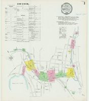
552. Winsted and West Winsted, Connecticut.
- Creator:
- Sanborn-Perris Map Co., issuing body
- Published / Created:
- 1897
- Call Number:
- 766 W73 1897
- Image Count:
- 9
- Resource Type:
- Maps, Atlases & Globes
- Abstract:
- Sanborn fire insurance maps are a rich source of historic data on the urban built environment of North America during the 19th and early 20th centuries. The atlases were created for the purpose of underwriting fire insurance policies, which depended upon accurate and frequently-updated information about construction materials, municipal and transportation infrastructure, industrial and commercial landuse and more. The Yale University Library Map Department scanned its holdings of Sanborn fire insurance maps (consisting primarily of Connecticut towns) in order to make the maps more accessible.
- Alternative Title:
- Sep. 1897, Winsted and W. Winsted, Conn.
- Description:
- "9 sheets 1442.", Contains information on population, prevailing winds, water facilities and fire department., Includes index of streets and specials., Partial cadastral map., and SMLMAPL 766 W73 1897: Sheets disbound. "Triplicate" stamp on sheets. Library of Congress copyright stamp on title sheet.
- Subject (Geographic):
- Winsted (Conn.)--Maps
- Subject (Name):
- Library of Congress Stamp
- Subject (Topic):
- Fire risk assessment--Connecticut--Winsted--Maps and Real property--Connecticut--Winsted--Maps
- Found in:
- Beinecke Rare Book and Manuscript Library > Winsted and West Winsted, Connecticut.
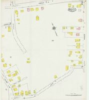
553. Winsted, Litchfield County, Connecticut.
- Creator:
- Sanborn Map Company, issuing body
- Published / Created:
- 1919
- Call Number:
- 766 W73 1919
- Image Count:
- 22
- Resource Type:
- Maps, Atlases & Globes
- Abstract:
- Sanborn fire insurance maps are a rich source of historic data on the urban built environment of North America during the 19th and early 20th centuries. The atlases were created for the purpose of underwriting fire insurance policies, which depended upon accurate and frequently-updated information about construction materials, municipal and transportation infrastructure, industrial and commercial landuse and more. The Yale University Library Map Department scanned its holdings of Sanborn fire insurance maps (consisting primarily of Connecticut towns) in order to make the maps more accessible.
- Alternative Title:
- Aug. 1919, Winsted, Conn.
- Description:
- "23 sheets (2780).", Contains information on population, prevailing winds, water facilities and fire department., Includes index of streets and specials., Missing first sheet with index map., Partial cadastral map., and SMLMAPL 766 W73 1919: Imperfect: Original title sheet wanting; photocopy included. Sheets disbound. "Triplicate" stamp on sheets. Library of Congress copyright stamp on title sheet.
- Subject (Geographic):
- Winsted (Conn.)--Maps
- Subject (Name):
- Library of Congress Stamp
- Subject (Topic):
- Fire risk assessment--Connecticut--Winsted--Maps and Real property--Connecticut--Winsted--Maps
- Found in:
- Beinecke Rare Book and Manuscript Library > Winsted, Litchfield County, Connecticut.

554. Winsted, Litchfield County, Connecticut.
- Creator:
- Sanborn Map Company, issuing body
- Published / Created:
- 1931
- Call Number:
- 766 W73 1931
- Image Count:
- 23
- Resource Type:
- Maps, Atlases & Globes
- Abstract:
- Sanborn fire insurance maps are a rich source of historic data on the urban built environment of North America during the 19th and early 20th centuries. The atlases were created for the purpose of underwriting fire insurance policies, which depended upon accurate and frequently-updated information about construction materials, municipal and transportation infrastructure, industrial and commercial landuse and more. The Yale University Library Map Department scanned its holdings of Sanborn fire insurance maps (consisting primarily of Connecticut towns) in order to make the maps more accessible.
- Alternative Title:
- Jan. 1931, Winsted, Conn. and Winsted, Litchfield County, Connecticut, including Riverton
- Description:
- "(1087) (23 sheets).", Contains information on population, prevailing winds, water facilities and fire department., Includes index of streets and specials., Partial cadastral map., and SMLMAPL 766 W73 1931: Sheets disbound. "Triplicate" stamp on sheets. Library of Congress copyright stamp on title sheet.
- Subject (Geographic):
- Winsted (Conn.)--Maps
- Subject (Name):
- Library of Congress Stamp
- Subject (Topic):
- Fire risk assessment--Connecticut--Winsted--Maps and Real property--Connecticut--Winsted--Maps
- Found in:
- Beinecke Rare Book and Manuscript Library > Winsted, Litchfield County, Connecticut.
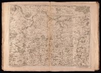
555. [Map of northern Luxembourg and part of Luxembourg province in Belgium] / dresseíe sur les memoires de Eugene Henry Frix.
- Creator:
- Crépy (Firm)
Fricx, Eugène-Henri, d. 1733
Fricx, Eugène-Henri, d. 1733. Cartes des provinces des Pays Bas - Published / Created:
- en 1744.
- Call Number:
- 1977 Folio 177
- Image Count:
- 2
- Resource Type:
- Maps, Atlases & Globes
- Description:
- "No. 15" in lower right corner, outside of neat line., Bar scales given in "echelle de deux lieues et demie comune de France" and "echelle de deux lieues de Brabant"., From Fricx's Cartes des provinces des Pays Bas, 1744., Prime meridian: Ferro., Relief shown by hachures., Sheet measures 55.3 x 72.3 cm. No. 32 of 34 maps bound together., Title devised by cataloger., and Watermark.
- Publisher:
- Chez Crepy rue S. Jacques a limage S. Pierre,
- Subject (Geographic):
- Luxembourg (Belgium)--Maps--Early works to 1800 and Luxembourg (Luxembourg)--Maps--Early works to 1800
- Found in:
- Beinecke Rare Book and Manuscript Library > [Map of northern Luxembourg and part of Luxembourg province in Belgium] / dresseíe sur les memoires de Eugene Henry Frix.