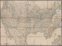
"12-20'27" and "5410." and Includes inset of "Canadian Pacific Railway and steamship lines."
Publisher:
Poole Bros.,
Subject (Geographic):
Canada--Maps and United States--Maps
Subject (Name):
Canadian Pacific Railway Company, Duluth, South Shore, and Atlantic Railway Company, Duluth, South Shore, and Atlantic Railway Company--Maps, and Spokane International Railway--Maps
Subject (Topic):
Railroads--Canada--Maps and Railroads--United States--Maps
Sportsman's map of Canada and the Northwest Territory.
Description:
Date taken from Yale card catalog indicating map was originally in cover with date of issue, March 1901; also with a cover title, "The sportsman's map of Canada and the Northwest Territory." and Relief shown by hachures.
Publisher:
Poole Bros.,
Subject (Geographic):
Canada--Maps and United States--Maps
Subject (Name):
Canadian Pacific Railway Company, Canadian Pacific Railway Company--Maps, Duluth, South Shore, and Atlantic Railway Company, and Duluth, South Shore, and Atlantic Railway Company--Maps
Subject (Topic):
Railroads--Canada--Maps and Railroads--United States--Maps
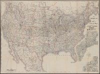
New official railroad map of the United States, Canada and Mexico.
Description:
Includes 9 insets., Insets: Atlantic Coast states, enlarged scale ; Important cities., Northern Canada and southern Mexico not shown., On verso: Publisher's advertisements., and Relief shown by hachures.
Publisher:
Rand McNally,
Subject (Topic):
Railroads--Canada--Maps, Railroads--Mexico, North--Maps, Railroads--North America--Maps, and Railroads--United States--Maps