Skip to search
Skip to main content
Skip to first result
Search
You Searched For
Genre
Manuscript maps
Resource Type
Maps, Atlases & Globes
New Search
Search Results
Published / Created:
[ca. 1725]
Call Number:
6555cea 1725
Container / Volume:
BRBL_00708
Image Count:
1
Resource Type:
Maps, Atlases & Globes
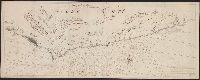
Description:
Color: Pen and ink drawing.
Subject (Geographic):
Ghana--Maps, Manuscript--Early works to 1800
Found in:
Beinecke Rare Book and Manuscript Library > Goud Kust.
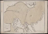
Published / Created:
1726
Call Number:
303cea 1726
Container / Volume:
BRBL_00701
Image Count:
1
Resource Type:
Maps, Atlases & Globes
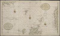
Description:
Manuscript Sea Chart., Neatly drawn in shades of green., and Tot Amsterdam by Gerard van Keulen aan de Nieuwen Brugh, 1726.
Subject (Geographic):
Europe, Northern--Maps, Manuscript--Early works to 1800
Found in:
Beinecke Rare Book and Manuscript Library > Het Nooderdeel van De Noord Zee seer Dienstig voor de Oost Indische Knuysors.
Published / Created:
1597
Call Number:
43 G99 1597
Container / Volume:
BRBL_00706
Image Count:
1
Resource Type:
Maps, Atlases & Globes
Description:
Color: Green and blue., Drawing of queen receiving visitors., and Original manuscript drawing for map in Civitatis Orbis Terrarum (Vol. V, p. 154).
Subject (Geographic):
Gyor (Hungary)--Maps, Manuscript--Early works to 1800
Found in:
Beinecke Rare Book and Manuscript Library > Iaverinum, vulgo Rab [Gyor, Hungary] Iaverinum olim anno MDLXVI à Nicolao Aginelli Italo acuratissime delineatum ex manisculo in minorem tabullam traductum Amicis Agrippensibus id requiventib. amice communicat Georius Houfnaglius MDXCVII.
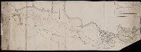
Published / Created:
1774
Call Number:
3331gmg H876 1774
Container / Volume:
BRBL_00701
Image Count:
1
Resource Type:
Maps, Atlases & Globes
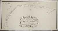
Description:
Gecopieert na de gereduceerde Kaart van D. Klinkenberg door J. Schilling in February 1779. and Manuscript map of coastline.
Subject (Geographic):
North Holland (Netherlands)--Maps, Manuscript--Early works to 1800
Found in:
Beinecke Rare Book and Manuscript Library > Kaart van den tegenwoordigen Zee-Dyk liggende voor de Landen van Muisduinen en de Helder, strekkende van het Nieuwe-Diep tot aan Kykduin, mitsgaders de diepte voor dezelve gepeild, van twee tot twee Roeden naar Zee, met Hoog-Water in Amsterd. Voeten door
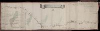
Published / Created:
1779
Call Number:
3331gmg H788 1749
Container / Volume:
BRBL_00701
Image Count:
1
Resource Type:
Maps, Atlases & Globes
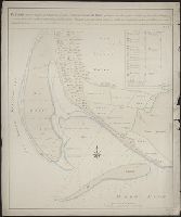
Description:
Manuscript map showing sandbanks of the southwest coast of the Island of Texel also waterdepths and their changes between the years 1749 and 1760.
Subject (Geographic):
North Holland (Netherlands)--Maps, Manuscript--Early works to 1800
Found in:
Beinecke Rare Book and Manuscript Library > Kaarte van de lengte en breete der Zand - Plaat genaamd De Horst ...
Call Number:
BrSides Folio 2019 56
Image Count:
1
Resource Type:
Maps, Atlases & Globes
Alternative Title:
Карта : описи и промеру глубины, части дниепровскаго Лимана и реки Буга до Николаева / сочинена флота господином капитанъ лейтнантомъ Александром Савицкимъ 1793 года.
Description:
Depths shown by soundings.
Subject (Geographic):
Dnieper River--Maps--Early works to 1800.
Subject (Name):
Savit︠s︡kiĭ, Aleksandr, -1799. and Савицкий, Александр, -1799.
Found in:
Beinecke Rare Book and Manuscript Library > Karta : opisi i promeru glubiny, chasti dnieprovskago Limana i reki Buga do Nikolaeva / sochinena flota gospodinom kapitanʺ leĭtnantomʺ Aleksandrom Savit︠s︡kimʺ 1793 goda.
Creator:
Published / Created:
[between 1762 and 1796]
Call Number:
BrSides Double Folio 2019 77
Image Count:
1
Resource Type:
Maps, Atlases & Globes
Alternative Title:
Карта большой Санктпетербургской дороге лежашей чрезъ Тверскую губернію / губернский землемеръ Андрей Петин.
Description:
Includes two insets, one showing the number of inhabitants in the 46 towns and villages along the road, the other the distances between various locations. and Mounted on silk. Manuscript annotation on map.
Subject (Geographic):
Tverskai︠a︡ oblastʹ (Russia)--Maps--Early works to 1800.
Found in:
Beinecke Rare Book and Manuscript Library > Karta bolʹshoĭ Sanktpeterburgskoĭ doroge lezhasheĭ chrezʺ Tverskui︠u︡ gubernīi︠u︡ / gubernskiĭ zemlemerʺ Andreĭ Petin.
Creator:
Published / Created:
[1785?]
Call Number:
BrSides Double Folio 2019 76
Image Count:
1
Resource Type:
Maps, Atlases & Globes
Alternative Title:
Карта реки Дниепра ивсего Лимана отъ Херсона до мыса А., Кинбурнскои берегъ / описи флота капитана второго ранга Берсенева 1785 года. Очаговскои берегъ наложенъ спрежднихъ картъ, глубина назначена въ футахъ.
Description:
Annotations on verso of map: "Liman de Dnjepr", "Liman[undeciphered] - 4, zabzan.[?] 3". Stained and repaired, lacking blank corner., Coordinates not present on maps and are approximated., and Relief shown by shadings. Depths shown by soundings.
Subject (Geographic):
Khersonsʹka oblastʹ (Ukraine)--Maps--Early works to 1800.
Found in:
Beinecke Rare Book and Manuscript Library > Karta reki Dniepra ivsego Limana otʺ Khersona do mysa A., Kinburnskoi beregʺ / opisi flota kapitana vtorogo ranga Berseneva 1785 goda. Ochagovskoi beregʺ nalozhenʺ sprezhdnikhʺ kartʺ, glubina naznachena vʺ futakhʺ.
Creator:
Published / Created:
Au mois de Dec. 1774.
Call Number:
BrSides Folio 2019 58
Image Count:
1
Resource Type:
Maps, Atlases & Globes
Alternative Title:
Karte von der Meerenge zwischen dem Schwarzen und Assowschen Meere
Description:
Includes key of fortifications, camps, and water sources. and Relief shown by hachures. Depths shown by soundings.
Subject (Geographic):
Azov, Sea of (Ukraine and Russia)--Maps--Early works to 1800. and Kerch Peninsula (Ukraine)--Maps--Early works to 1800.
Found in:
Beinecke Rare Book and Manuscript Library > Karte von der Merenge zwischen dem Schwarzen und Assowschen Meere, wie auch von dem Stücke der Krim so Russland gehoeret. Anno 1774 / L. A. Colo. Mellin, Lieutenant de L'Etat Major de l'armee, fec.
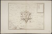
Published / Created:
1612
Call Number:
38 H453 1612
Container / Volume:
BRBL_00703
Image Count:
1
Resource Type:
Maps, Atlases & Globes
Description:
Color: Pen drawing.
Subject (Geographic):
Hesdin (France)--Maps, Manuscript--Early works to 1800
Found in:
Beinecke Rare Book and Manuscript Library > La Ville de Hesdin.
Branch:v1.61.6 ,Deployed:2024-06-12T09:55:33-04:00