Browne, Christopher, fl. 1684-1712 Fer, Nicolas de, 1646-1720, creator
Published / Created:
[1704?]
Call Number:
1973 Folio 10
Image Count:
1
Resource Type:
Maps, Atlases & Globes
Alternative Title:
New map of the theatre of the war in Flanders and on the Rhine and Theatre of the warr in Flanders
Description:
Bar scales given in English miles., Dedicated to Q. Anne by C. Browne., Ferro meridian., Includes inset map the Rhine River Valley., No. 46 of 69 maps bound together in composite atlas., Relief shown pictorially., and Scale [ca. 1:600 000].
Publisher:
Made english and sold by C. Browne at the Globe at the west end of St. Pauls Church
Title and date from item., In upper right margin: 112., and This electronic record is derived from historic data and may not reflect our current information. Review and updating of records is ongoing.
Publisher:
Printed for Bowles & Carver, No. 69 in St. Pauls Church Yard, London. Publishd as the Act directs
Subject (Topic):
Obesity, Indigestion, Dogs, Seesaws, Children, and Eating & drinking
Title from item., Date and place of publication from item., Sheet trimmed., and This electronic record is derived from historic data and may not reflect our current information. Review and updating of records is ongoing.
Publisher:
Published Jany. 1st, 1795 by James Wales of Bombay at Mr. R. Cribbs, Carver & Gilder 288 Holborn, London
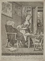
Description from similar print in Lewis Walpole Library: A sleeping clergyman sits in an armchair, oblivious to a maid tickling his nose with the tail of a sucking pig, just delivered by a man standing in the open doorway. On a table is an inkstand and quill, a wine bottle, glass and candle with a book entitled "Tythe laws fully consider'd". At cat pulls from the table a paper labelled "Bans of marriage", while on the floor near a small dog a large book lies open to "Poem on good living". The clergyman's portrait and that of a woman hang on the wall behind him beside a map entitled "A Plan of the doctor's parish."
Description:
Title below image., Date supplied by curator., Below title is a poem in three columns: "The well fed rich Doctor now Dinner is o'er, In his Arm Chair gives way to an Afternoon's snore ..., In margin lower right: 102., and This electronic record is derived from historic data and may not reflect our current information. Review and updating of records is ongoing.
Publisher:
Printed for & Sold by Bowles & Carver, at their Map and ... Print Warehouse, No. 69 in St. Paul's Church Yard, London
Subject (Geographic):
England. and England
Subject (Name):
Church of England
Subject (Topic):
Clergy, Tithes, Clothing & dress, Practical jokes, Dogs, and Swine
Caption title., Printed on silk, within decorative borders. Engraved portrait of "Caroline Queen of England" beneath title., Broadside addressed from the Brass Founders and Braziers in support of Queen Caroline in October 1820, a month before the withdrawal of the Pains and Penalties Bill which aimed to annul Caroline’s marriage to George IV. Beneath the address is a response from Queen Caroline together with an ‘Order of the Procession’ in support of the queen., First lines: May it please Your Most Excellent Majesty. We, the operative Workers of Brass ... do most humbly and dutifully approach your Most Gracious Majesty, to offer our congratulations on your Majesty’s return ..., and For further information, consult library staff.
Publisher:
Printed and published by J. Cowie, 58 Shoe Lane, Holborn
Subject (Name):
Caroline, Queen, consort of George IV, King of Great Britain, 1768-1821. and Brass Founders and Braziers.
Africa distinguished into its principall parts viz. Barbary, Biledulgerid, Egypt, Zaara or the Desart, the Country of the Negroes, Guinea, Nubia, Abissinea, Zanguebar, Congo, Monomotapa, Caffrares, the Islands of the Canaries, Cape Verd, St. Thomas, Madagascar or St. Lawrence in which are observed the empires, monarchies, kingdomes, states and peoples, which at present inhabite Africa
Description:
Ferro meridian., No. 56 of 69 maps bound together in composite atlas., Relief shown pictorially., Scale [ca 1:34 000 000]., and To the most serene and most sacred majesty of Charles II, by the grace of God, king of Great Brittain, France, and Ireland, this map of Africa is humbly dedicated and presented by your majesties loyal subject and servant, William Berry.
Publisher:
Sold by William Berry at the sign of the globe between Charing Cross and White-Hall