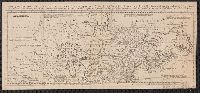
Map of the British and French Plantations in North America.
Description:
From The London Magazine (August 1755), vol. 24, p. 360., Prime meridian: London., Relief shown pictorially., Sheet measures 22.3 x 29.1 cm. Cross Collection no. 192., and Shows New England, Maritime Provinces, and eastern Quebec.
Publisher:
London Magazine,
Subject (Geographic):
Maritime Provinces--Maps--Early works to 1800, New England--Maps--Early works to 1800, and Quebec--Maps--Early works to 1800
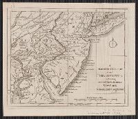
From Gentleman's Magazine, July 1754, opp. page 322., Imperfect: mutilated, with no loss of text. Sheet measures 24 x 29.8 cm. Cross Collection no. 183., Ornamental cartouche surrounding title., Prime meridian: London., and Relief shown pictorially.
Publisher:
Gentleman's Magazine],
Subject (Geographic):
Great Britain--Colonies--America--Maps--Early works to 1800 and United States--Maps--Early works to 1800
Imperfect: 2nd part of map wanting. Mounted on linen. Sheet measures 22.4 x 49.5 cm. Cross Collection no. 151., Prime meridian: London., pt. the first. Containing Canada, Nova scotia, Newfoundland, New England, part of New York, with the Lakes, Six Nations, and all the countries westward in the same parallels so far as discover'd; exhibiting the just boundaries, and the French encroachments: laid down from authentic surveys -- pt. the second. Containing part of New York, Pensilvania, New Jersey, Mary Land, Virginia, North & South Carolina, Georgia, Louisiana, and all the countries westward in the same parellels so far as discovered, shewing the course of the Rivers Ohio, Missisipi &c. exhibiting the just boundaries & the French encroachments laid down from authentic surveys., Relief shown pictorially., and Shows boundaries, rivers, forests, principal settlements and notes.
Publisher:
s.n.,
Subject (Geographic):
France--Colonies--America--Maps--Early works to 1800, Great Britain--Colonies--America--Maps--Early works to 1800, and North America--Maps--Early works to 1800
Map of the five Great Lakes with part of Pennsylvania, New York, Canada and Hudsons Bay territories &c.
Description:
From The London Magazine (September 1755), v. 24, p. 432., Prime meridian: London., Relief shown pictorially., and Sheet measures 22.7 x 29.4 cm. Cross Collection no. 193.
Publisher:
s.n.,
Subject (Geographic):
Great Lakes (North America)--Maps--Early works to 1800
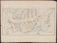
[Gulf of St. Laurence] -- The contents of the respective divisions of the island of St. John -- A list of lots and proprietors names., Depths shown by soundings., and Hand col. Sheet measures 55.2 x 73.8 cm. Cross Collection no. 172.
Publisher:
R. Sayer & J. Bennett?],
Subject (Geographic):
Prince Edward Island--Administrative and political divisions--Maps--Early works to 1800
Subject (Name):
Holland, Samuel, 1728-1801
Subject (Topic):
Real property--Prince Edward Island--Maps--Early works to 1800
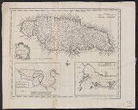
Draught of Port Royal or Kingston Harbour in Jamaica., Draught of the harbour of Port Antonio & St. Francis on the north east coast of Jamaica, and New and accurate map of the Island of Jamaica
Description:
From Bowen's Complete system of geography. London : Printed for William Innys, Richard Ware, Aaron Ward ..., 1747., London meridian., Scale given in English miles., Sheet measures 40.7 x 50.7 cm., and Shows boundaries, roads, forests, plantations and settlements.
Publisher:
s.n.,
Subject (Geographic):
Jamaica--Maps--Early works to 1800
Subject (Name):
Bowen, Emanuel, d. 1767. Complete system of geography
Subject (Topic):
Harbors--Jamaica--Kingston--Maps--Early works to 1800, Harbors--Jamaica--Port Antonio--Maps--Early works to 1800, and Harbors--Jamaica--Port Royal--Maps--Early works to 1800