Automobile map of New Hampshire, central and Automobile map of New Hampshire, south
Description:
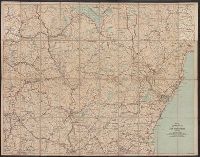
Automobile map of New Hampshire, south, No. 13 -- Automobile map of New Hampshire central, No. 14., Maps mounted on cloth backing., Relief shown by hachures., Shows southeastern New Hampshire and some of Maine and Massachusetts, from Saco, Me. in the northeast to Newbury, Mass. in the southeast and Orange, N.H. in the northwest to Rindge, N.H. in the southwest., and Title from panel.
Copyright: 1905 by the Federal Engraving and Publishing Co., Boston, Mass., Index to points of interest on cover., Oriented with north to the left., and Title from cover.
Publisher:
Published by John F. Murphy,
Subject (Geographic):
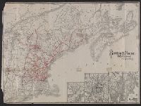
Boston Harbor (Mass.)--Maps, Boston Harbor Islands (Mass.)--Maps, Boston Harbor Region (Mass.)--Maps, and South Shore Region (Mass. : Coast)--Maps
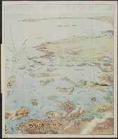
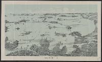
Bird's eye view from Mt. Washington, New Hampshire
Description:
"Issued by Passenger Department of Boston & Maine R.R.", Includes key to 189 places., and Panel title: Bird's eye view from Mt. Washington, New Hampshire.
Publisher:
Geo. H. Walker & Co.,
Subject (Geographic):
Washington, Mount (N.H.)--Maps and White Mountains (N.H. and Me.)--Maps