Skip to search
Skip to main content
Skip to first result
Search
You Searched For
Format
cartographic
Publication Place
Philadelphia :
New Search
Search Results
Published / Created:
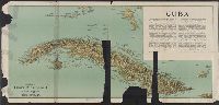
[1897?]
Call Number:
855cbf 1897A
Container / Volume:
BRBL_00642
Image Count:
1
Resource Type:
Maps, Atlases & Globes
Description:
Imperfect. Mutilated. Map torn into 2 sheets, each encased in mylar. and Text detailing historical and geographic information.
Publisher:
James McConnell School Supply Co.,
Subject (Geographic):
Cuba--Maps
Found in:
Beinecke Rare Book and Manuscript Library > Cuba
Published / Created:
1915
Call Number:
774 Y82 1915
Container / Volume:
BRBL_00500
Image Count:
1
Resource Type:
Maps, Atlases & Globes
Description:
Also shows railroads, inter-urban electric lines, main roads., Roads in each townships are numbered., and Zincograph colored to show townships.
Publisher:
Wilmer Atkinson Company ,
Subject (Geographic):
York County (Pennsylvania)--Maps
Found in:
Beinecke Rare Book and Manuscript Library > Farm journal map of York County, Pennsylvania.
Creator:
Published / Created:
1878
Call Number:
783 H189 1878
Container / Volume:
BRBL_00510
Image Count:
1
Resource Type:
Maps, Atlases & Globes
Alternative Title:
Map of Hampton and New map of Hampton
Description:
Includes some historic notes for specific sites. and Shows names of streets, landowners, Hampton Creek and Hampton Road, location of businesses, and other points of interest.
Publisher:
Drawn, engraved, and published by O. W. Gray & Son,
Subject (Geographic):
Hampton (Va.)--Maps
Subject (Topic):
Real property--Virginia--Hampton--Maps
Found in:
Beinecke Rare Book and Manuscript Library > Gray's new map of Hampton : Elizabeth City County, Va. : drawn from special surveys.
Creator:
Published / Created:
1867
Call Number:
774G 1867
Container / Volume:
BRBL_00501
Image Count:
1
Resource Type:
Maps, Atlases & Globes
Description:
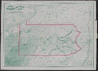
Shows coal and oil regions from Lake Ontario through much of West Virginia; most of New York State is shown, though without geological detail. Also shows locations of steel works, foundries, etc.
Publisher:
Jacob Haehnlen [lithographer],
Subject (Geographic):
Pennsylvania--Maps
Subject (Topic):
Canals--Pennsylvania--Maps, Coal--Pennsylvania--Maps, Iron industry and trade--Pennsylvania--Maps, and Railroads--Pennsylvania--Maps
Found in:
Beinecke Rare Book and Manuscript Library > Iron, railroad, canal and coal map of Pennsylvania, &c. : showing the relative position of the various anthracite and bituminous coal fields, the railroads, canals and navigable waters by which they are connected forming their respective avenues to market
Creator:
Published / Created:
1866
Call Number:
894gme 1866
Container / Volume:
BRBL_00659
Image Count:
1
Resource Type:
Maps, Atlases & Globes
Description:
"To accompany Report of Rear Admiral C. H. Davis, U.S.N., ordered by Resolution of the Senate of the United States of March 19, 1866., From: Charles H. Davis' Report on interoceanic canals and railroads between Atlantic, and North oriented to left side of map.
Publisher:
Bowen & Co.,
Subject (Geographic):
Honduras--Maps
Subject (Name):
Bowen & Co, Davis, Charles Henry, 1807-1877, Honduras Interoceanic Railway Company, Jeffers, William N. (William Nicholson), 1824-1883, Squier, E. G. (Ephraim George), 1821-1888, and Trautwine, John C. (J
Subject (Topic):
Railroads--Honduras--Maps
Found in:
Beinecke Rare Book and Manuscript Library > Map and vertical section of the proposed Honduras Interoceanic Railway : Located 1857 & 58. / Drawn by G. Thompson, 1866.
Creator:
Published / Created:
1862
Call Number:
834gbc 1862
Image Count:
1
Resource Type:
Maps, Atlases & Globes
Description:
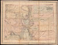
Hand col. to show county boundaries and county area tints., Hand colored, mounted on cloth., and Relief shown by hachures.
Publisher:
Jacob Monk,
Subject (Geographic):
Colorado and Colorado--Maps.
Subject (Name):
Gilpin, William, 1813-1894., Monk, Jacob., and T. Sinclair's Lith.
Found in:
Beinecke Rare Book and Manuscript Library > Map of Colorado Territory embracing the Central Gold Region [cartographic material] / drawn by Frederick J. Ebert ; under direction of the Governor Wm. Gilpin.
Creator:
Published / Created:
[1892?]
Call Number:
783 EL48 1890
Container / Volume:
BRBL_00510
Image Count:
1
Resource Type:
Maps, Atlases & Globes
Description:
Oriented with north to the upper right.
Publisher:
E.W. Smith & Co., Map Establishment, 17 & 19 South 6th St.,
Subject (Geographic):
Hampton (Va.)--19th century--Maps
Subject (Name):
E.W. Smith & Co, Hubbard, C., surveyor, and Ivy, Wm
Found in:
Beinecke Rare Book and Manuscript Library > Map of Elizabeth City Co., Va. : from actual surveys by E.A. Semple, Wm. Ivy and C. Hubbard / compiled and platted by E.A. Semple, civil engineer and county surveyor.
Branch:v1.61.6 ,Deployed:2024-06-12T09:55:36-04:00