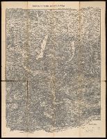
From Francesco Saverio Clavigero's Historia Antigua de Megico., Imperfect: torn along folds and edges, with some loss of text. Stamps on verso: The South American Exploration Fund, Yale University; Bought of F. Perez de Velasco, October, 1912., and Relief shown pictorially.
Publisher:
Publicado por el Sr. R. Ackermann en Londres y en Megico,
Subject (Geographic):
Mexico--Maps.
Subject (Name):
Clavigero, Francesco Saverio, 1731-1787. Storia antica del Messico. Spanish., Neele, Samuel John, 1758-1824, engraver., and South American Exploration Fund (Yale University) Ownership.
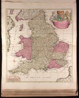
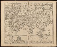
"Cum privilegio.", Appeared in Peter Schenk's Atlas contractus, ca. 1700., Backed with paper. Ms. no. "48" in lower-right corner. Sheet measures 62.8 x 53.7 cm. No. 45 of 87 maps bound together., Bar scales given in "milliaria Anglica," "milliaria Germanica," and "milliaria Gallica"., Prime meridian: Ferro., Relief shown pictorially., and Watermark.
Publisher:
Peter Schenk,
Subject (Geographic):
England--Maps--Early works to 1800.
Subject (Name):
Schenk, Peter, 1660-1718 or 1719. Atlas contractus.
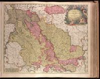
"Cum privil. H. et W-frisiae"., Appeared in Valk and Schenk's Atlantis sylloge compendiosa, ca. 1702., Backed with paper. Ms. no. "36" in upper left-hand corner. Sheet measures 53.6 x 62.8 cm. No. 35 of 87 maps bound together., Bar scales given in "milliaria Germanica," "milliaria Gallica," and "milliaria Italica"., Prime meridian: Ferro., Relief shown pictorially., and Watermark.
Publisher:
Gerard Valk,
Subject (Geographic):
Limburg (Belgium : Province)--Maps--Early works to 1800. and North Rhine-Westphalia (Germany)--Maps--Early works to 1800.
Subject (Name):
Schenk, Peter, 1660-1718 or 1719. Atlantis sylloge compendiosa. and Valck, G. (Gerard), 1651 or 1652-1726. Atlantis sylloge compendiosa.
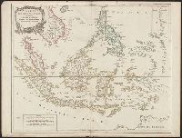
Covers present-day Indonesia, the Philippines, Malayan peninsula, Indo-Chinese peninsula, and north-west coast of Australia., From: Atlas universel / par m. Robert geographe et Robert de Vaugondy son fils. Paris, 1757-[1786]., Includes inset map., and Inset: Isl
Publisher:
[publisher not identified],
Subject (Geographic):
Asia--East Indies, Australia--Maps--Early works to 1800., East Indies--Maps--Early works to 1800., Mariana Islands--Maps--Early works to 1800., and Southeast Asia--Maps--Early works to 1800.
Subject (Name):
Haye, G. de la, engraver. and Robert de Vaugondy, Gilles, 1688-1766. Atlas universel.
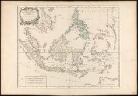
"Archipel des Indes" stamped twice on verso., Appeared in: Gilles and Didier Robert de Vaugondy, "Atlas Universel", 1753-1757 [or later]., Covers present-day Indonesia, the Philippines, Malayan peninsula, Indo-Chinese peninsula, and north-west coast of Australia., Includes inset map., Inset: Isles Marianes des Larons., Relief shown pictorially., and Watermarks.
Publisher:
[publisher not identified],
Subject (Geographic):
Southeast Asia--Maps--Early works to 1800.
Subject (Name):
Haye, G. de la, engraver., Robert de Vaugondy, Didier, 1723-1786. Atlas Universel., and Robert de Vaugondy, Gilles, 1688-1766. Atlas universel.
Touristen-karten im Massstabe von 1:129,600 and Umgebung von Gmunden, Ischl, Hallstadt, Aufsee
Description:
Imperfect: all sheets but sheet 2 wanting. "Uebersichtsblatt zu R. Maschek's Touristenkarte" pasted on verso., Relief shown by hachures., and Title from panel pasted on verso.
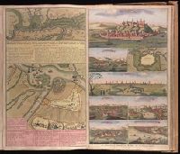
Accurate aftekening hoe de twee Legers geleegen hebben voor Belgrado, ent bomberderen en kanonneeren op malkanderen van den 2 tot den 14 Augustus anno 1717 and Nieuwe accurate kaart van de marse der Keyserlyke armee van Peter Wardien en Futak.
Description:
Backed with paper. Ms. no. in upper right corner [illegible due to trimming]. Sheet measures 53.8 x 62.4 cm. No. 74 of 87 maps bound together., On sheet with 1 other map ("Nieuwe accurate kaart van de marse der Keyserlyke armee van Peter Wardien en Futak ... tot voor Belgrado ... 9 tot den 19 Iuny anno 1717") and 7 bird's-eye views ("Belgrad," "Temeswar" [with map "De Stadt Temeswar"], "Temeswar" [2], "Wardien," "Offen v. Pest," "Sigeth," and "Citta e porto di Constantinopoli")., Relief shown pictorially., and With inset bird's-eye view of Belgrade in upper left corner.
Appeared in Valk and Schenk's Atlantis sylloge compendiosa, ca. 1702., Backed with paper. Ms. no. "61" in upper right-hand corner. Sheet measures 53.1 x 62.3 cm. No. 56 of 87 maps bound together., Bar scales given in "milliaria Gallica" and "milliaria Germanica.", Prime meridian: Ferro., and Relief shown pictorially.
Publisher:
Ger. et Leo. Valk,
Subject (Geographic):
Orléanais (France)--Maps--Early works to 1800.
Subject (Name):
Schenk, Peter, 1660-1718 or 1719. Atlantis sylloge compendiosa., Valck, G. (Gerard), 1651 or 1652-1726. Atlantis sylloge compendiosa., and Valck, Leonard, 1675-1746.