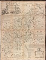
Dedication in decorative cartouche: To the Right Honble. George Montagu Earl of Halifax, Lord Lieutenant & Custos Rotulorum for the County of Northampton & First Commissioner of the Plantation Office. This map is humbly dedicated by His Lordship's obedt. servant Eman. Bowen., Dissected and mounted on linen., Includes text on some towns, their manufactures and natural products, Earls of Northampton, and seats of the Nobility., Plate 26 from: The large English atlas, or, A new set of maps of all the counties in England and Wales / Emanuel Bowen. London: Printed and sold by Robert Wilkinson, at No. 58, in Cornhill, successor to Mr John Bowles, deceased, [1785]., Prime meridian: London., and Relief shown pictorially.
Publisher:
Printed for Robt. Wilkinson, Cornhill & Robt. Sayer in Fleet Street, Carrington Bowles in St. Pauls Church Yard,
Subject (Geographic):
Northamptonshire (England)--Maps--Early works to 1800.
Subject (Name):
Bowen, Emanuel, 1693 or 1694-1767. Large English atlas, or, A new set of maps of all the counties in England and Wales., Bowles, Carington, 1724-1793, Sayer, Robert, 1725-1794, and Wilkinson, Robert, -approximately 1825
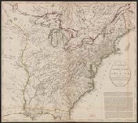
2nd state. Distinguishing feature of 2nd state: "Title changed slightly to read 'An accurate map of the British Colonies...'" (McCorkle 111)., 755 1756F: Verso: Stamped "Oct 23 1959"., Printed text in left and right margins., and Published separately as broadsid
Publisher:
printed for and sold by H. Overton,
Subject (Geographic):
North America--Maps--Early works to 1800 and United States--History--French and Indian War, 1755-1763--Maps--Early works to 1800
Covers from Maine to South Carolina and west to Lake Michigan., From Universal magazine of knowledge and pleasure, Dec., 1754, v. 15, pg. 241., and Relief shown pictorially.
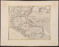
"No. 57.", From Bowen's A complete system of geography ... London : Printed for W. Innys, R. Ware, Aaron Ward ..., 1747., Includes bar scale in English miles., Relief shown pictorially., Sheet measures 44.9 x 58 cm. Cross Collection no. 243., and Shows sailing tracks, currents, shoals, etc.; includes historical notes and ornamental cartouche.
Publisher:
Printed for William Innys, Richard Ware, Aaron Ward ...,
Subject (Geographic):
Caribbean Area--Maps--Early works to 1800 and North America--Maps--Early works to 1800
Subject (Name):
Bowen, Emanuel, d. 1767. Complete system of geography