Skip to search
Skip to main content
Skip to first result
Search
You Searched For
Extent of Digitization
Partially digitized
Genre
Maps
New Search
Search Results
Call Number:
1971 Folio 602
Collection Title:
Carte topographique de lEgypte et de plusiers parties des pays limitrophes; levee pendant
Image Count:
1
Resource Type:
Maps, Atlases & Globes
Alternative Title:
Description de lEgypte
Subject (Geographic):
Egypt., Israel, Middle East., and Red Sea.
Collection Created:
Paris
Found in:
Beinecke Rare Book and Manuscript Library > [Map of Egypt, the Red Sea, Palestine, the Sinai Peninsula and other Middle Eastern landmarks]. pl. 2.
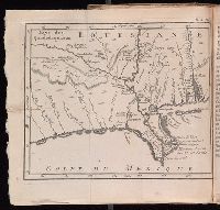
Call Number:
Zc20 758Le
Collection Title:
Histoire de la Louisiane : contenant la decouverte de ce vaste pays ; sa description geographique
Image Count:
1
Subject (Geographic):
Louisiana --Description and travel, Louisiana --History --To 1803, Louisiana --Maps --Early works to 1800, Mexico, Gulf of --Discovery and exploration --French, and Mexico, Gulf of --Maps --Early works to 1800
Subject (Topic):
Indians of North America --Mississippi River Valley and Natural history --Louisiana
Collection Created:
Paris : De Bure, l'aine [etc.], 1758
Found in:
Beinecke Rare Book and Manuscript Library > [Map of Louisiana]
Creator:
Published / Created:
Undated
Call Number:
Taylor 216A
Collection Title:
Iohn Huighen van Linschoten, his Discours of Voyages into ye Easte & West Indies : deuided into
Image Count:
1
Description:
Bound in following title page of second book. and Map has small tear at bottom fold in center.
Subject (Geographic):
Africa --Maps --Early works to 1800, Cape of Good Hope --Maps, Congo (Democratic Republic) --Maps, and Madagascar --Maps --Early works to 1800
Subject (Name):
Wolfe, John, d. 1601, printer
Subject (Topic):
Voyages and travels --Early works to 1800
Collection Created:
[London] : Printed at London by [John Windet for] Iohn Wolfe, printer to ye Honorable Cittie of London, [1598]
Found in:
Beinecke Rare Book and Manuscript Library > [Map of southern Africa and Madagascar]
Published / Created:
Undated
Call Number:
1983 Folio 1
Collection Title:
Chertezhnai'a' kniga Sibiri, sostavlennai'a' tobol'skim synom boi'a'rskim Semenom Remezovym v 1701
Image Count:
1
Resource Type:
Books, Journals & Pamphlets
Subject (Geographic):
China --Maps and Siberia (Russia) --Maps
Subject (Topic):
Great Wall of China (China)
Collection Created:
S.-Peterburg Izdano Arkheograficheskoi'u' kommisiei'u' izhdiveniem P.I. Likhacheva] 1882
Found in:
Beinecke Rare Book and Manuscript Library > [Map of southern Siberia]
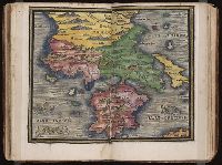
Published / Created:
[1542]
Call Number:
Taylor 86
Collection Title:
Rvdimenta cosmographica
Image Count:
1
Subject (Geographic):
Balkan Peninsula and Greece
Subject (Topic):
Cosmography, Early maps, and Geography, Medieval
Collection Created:
Impressvm in inclyta Transylvaniae Corona 1542
Found in:
Beinecke Rare Book and Manuscript Library > [Map of the Balkan Peninsula including Macedonia and Greece]
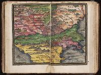
Published / Created:
[1542]
Call Number:
Taylor 86
Collection Title:
Rvdimenta cosmographica
Image Count:
1
Subject (Geographic):
Balkan Peninsula
Subject (Topic):
Cosmography, Early maps, and Geography, Medieval
Collection Created:
Impressvm in inclyta Transylvaniae Corona 1542
Found in:
Beinecke Rare Book and Manuscript Library > [Map of the Balkan Peninsula including Macedonia, Blugaria, Moldova]
Published / Created:
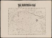
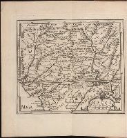
1739
Call Number:
1975 2757
Collection Title:
El atlas abreviado, ò, El nuevo compendio de la geografia universal, politica, historica, i curiosa
Image Count:
1
Resource Type:
Maps, Atlases & Globes
Publisher:
J. Certa
Collection Created:
Leon de Francia : J. Certa, 1739
Found in:
Beinecke Rare Book and Manuscript Library > [Map of] Mogol
Published / Created:
1802
Call Number:
Im B388 Zz802B
Collection Title:
The imperial guide : with picturesque plans of the great post roads, containing miniatures
Image Count:
1
Description:
Bound in between p. 24-25. and William Beckford’s copy, with his penciled annotations. Autograph of William Beckford.
Subject (Geographic):
England --Guidebooks, England --Maps, Great Britain --Description and travel --Views, and Great Britain --Road maps
Subject (Topic):
Roads --Great Britain
Collection Created:
London : Printed by C. Whittingham, Dean Street, Fetter Lane, and sold by H.D. Symonds, Paternoster-Row; [etc], 1802
Found in:
Beinecke Rare Book and Manuscript Library > [Map: Carlisle to Bolton]
Published / Created:
1802
Call Number:
Im B388 Zz802B
Collection Title:
The imperial guide : with picturesque plans of the great post roads, containing miniatures
Image Count:
1
Description:
Bound in between p. 4-5. and William Beckford’s copy, with his penciled annotations. Autograph of William Beckford.
Subject (Geographic):
England --Guidebooks, England --Maps, Great Britain --Description and travel --Views, and Great Britain --Road maps
Subject (Topic):
Roads --Great Britain
Collection Created:
London : Printed by C. Whittingham, Dean Street, Fetter Lane, and sold by H.D. Symonds, Paternoster-Row; [etc], 1802
Found in:
Beinecke Rare Book and Manuscript Library > [Map: Coventry to Stony Stratford]
Published / Created:
1802
Call Number:
Im B388 Zz802B
Collection Title:
The imperial guide : with picturesque plans of the great post roads, containing miniatures
Image Count:
1
Description:
Bound in between p. 38-39. and William Beckford’s copy, with his penciled annotations. Autograph of William Beckford.
Subject (Geographic):
England --Guidebooks, England --Maps, Great Britain --Description and travel --Views, and Great Britain --Road maps
Subject (Topic):
Roads --Great Britain
Collection Created:
London : Printed by C. Whittingham, Dean Street, Fetter Lane, and sold by H.D. Symonds, Paternoster-Row; [etc], 1802
Found in:
Beinecke Rare Book and Manuscript Library > [Map: Islip to Paddington]
Branch:v1.61.8 ,Deployed:2024-06-20T11:15:04-04:00