Skip to search
Skip to main content
Skip to first result
Search
You Searched For
Extent of Digitization
Partially digitized
Genre
Maps
New Search
Search Results
Call Number:
1977 +392
Collection Title:
A survey of the cities of London and Westminster : containing the original, antiquity, increase
Image Count:
1
Resource Type:
Maps, Atlases & Globes
Description:
Plate between p. 54-55.
Subject (Geographic):
London (England)--History
Collection Created:
London : Printed for A. Churchill, J. Knapton, R. Knaplock, J. Walthoe [and 6 others], 1720
Found in:
Beinecke Rare Book and Manuscript Library > Aldgate Ward with its division into parishes. Taken from the last survey, with corrections & additions
Call Number:
1977 1341
Collection Title:
Geographiae vniversae opvs habentur Cl. Ptolemaei ... Geographicae enarationis libri octo [tr. by W
Image Count:
1
Resource Type:
Books, Journals & Pamphlets
Subject (Topic):
Geography--Early works to 1800
Collection Created:
Venetiis : Apud Haeredes Simonis Galignani de Karera, 1596
Found in:
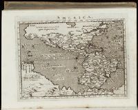
Beinecke Rare Book and Manuscript Library > America
Call Number:
Gfp94 gf525j
Collection Title:
Geographiae vniversae ... opvs ... habentur Cl. Ptolemaei ... Geographicae enarrationis libri octo
Image Count:
1
Resource Type:
Books, Journals & Pamphlets
Subject (Topic):
Geography--Early works to 1800
Collection Created:
Venetiis : Apud Haeredes Simonis Galignani de Karera, 1596
Found in:
Beinecke Rare Book and Manuscript Library > America
Creator:
Call Number:
C6 033c
Collection Title:
The natural and civil history of the French dominions in North and South America : with an
Image Count:
1
Resource Type:
Maps, Atlases & Globes
Description:
Plate between p. 68-9.
Subject (Geographic):
Atlantic Ocean--Charts, maps, etc., Atlantic Ocean--Maps--Early works to 1800, and Santo Domingo (Dominican Republic)
Collection Created:
London, Printed for T. Jeffreys, 1761
Found in:
Beinecke Rare Book and Manuscript Library > An authentic plan of the town and harbour of Cap Francois in the isle of St. Domingo. By Thomas Jefferys geographer to his Royal Highness the Prince of Wales
Call Number:
1973 Folio 114
Collection Title:
The English pilot: describing the West-India navigation, from Hudson's-Bay to the river Amazones
Image Count:
1
Resource Type:
Maps, Atlases & Globes
Subject (Geographic):
Atlantic Ocean --Maps --Early works to 1800, Central America --Maps --Early works to 1800, and Panama --Maps --Early works to 1800
Subject (Topic):
Navigation --Early works to 1800, Pilot guides --Atlantic Coast (U.S.) --Early works to 1800, and Pilot guides --Caribbean Area --Early works to 1800
Collection Created:
London : Printed for W. and J. Mount, T. Page and son, on Tower-Hill, MDCCLIX [1759]
Found in:
Beinecke Rare Book and Manuscript Library > An exact draught of the Gulf of Darien & the coast to Porto Bello with Panama in the South Sea & the Scotch settlement in Calledonia
Call Number:
1978 +73
Collection Title:
The ecclesiastical history of New-England from its first planting in the year 1620 unto the year of
Image Count:
1
Resource Type:
Books, Journals & Pamphlets
Description:
Verso blank.
Subject (Geographic):
New England --Biography, New England --Church history, and New England --History --Colonial period, ca. 1600-1775
Collection Created:
London, Printed for Thomas Parkhurst, at the Bible and Three Crowns in Cheapside, 1702
Found in:
Beinecke Rare Book and Manuscript Library > An exact mapp of New England and New York
Creator:
Published / Created:
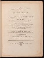
1797
Call Number:
CF1921 E38
Image Count:
2
Resource Type:
Books, Journals & Pamphlets
Publisher:
For J. Stockdale,
Subject (Geographic):
Haiti--History--Revolution, 1791-1804.
Subject (Name):
Stockdale, John, 1749?-1814
Found in:
Beinecke Rare Book and Manuscript Library > An historical survey of the French colony in the island of St. Domingo: comprehending a short account of its ancient government, political state, population, productions, and exports; a narrative of the calamities which have desolated the country ever since the year 1789 and a detail of the military transactions of the British army in that island to the end of 1794, by Bryan Edwards.
Published / Created:
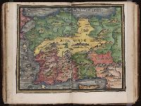
[1542]
Call Number:
Taylor 86
Collection Title:
Rvdimenta cosmographica
Image Count:
1
Subject (Geographic):
Asia and India
Subject (Topic):
Cosmography, Early maps, and Geography, Medieval
Collection Created:
Impressvm in inclyta Transylvaniae Corona 1542
Found in:
Beinecke Rare Book and Manuscript Library > Asia
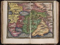
Published / Created:
[1542]
Call Number:
Taylor 86
Collection Title:
Rvdimenta cosmographica
Image Count:
1
Subject (Geographic):
Turkey
Subject (Topic):
Cosmography, Early maps, and Geography, Medieval
Collection Created:
Impressvm in inclyta Transylvaniae Corona 1542
Found in:
Beinecke Rare Book and Manuscript Library > Asia Minor
Creator:
Published / Created:
[1732]
Call Number:
E1015 M66 1732
Image Count:
1
Description:
Autograph of Gravely. Autograph of Baldock. Autograph of Aston. Autograph of W. Alington. and Teaching resource: Professor John Mack Faragher, History 141: The American West.
Publisher:
Printed for Thomas Bowles, next to the Chapter-house in St. Paul’s Church-yard, and John Bowles, at the Black Horse in Cornhill ...,
Subject (Geographic):
America--Maps--Early works to 1800
Subject (Topic):
Atlases--Early works to 1800
Found in:
Beinecke Rare Book and Manuscript Library > Atlas minor: or a set of sixty-two new and correct maps, of all parts of the world. All composed and done by Herman Moll, geographer ...
Branch:v1.61.8 ,Deployed:2024-06-20T11:14:55-04:00