Skip to search
Skip to main content
Skip to first result
Search
You Searched For
Format
cartographic
Genre
Topographic maps
Creator
Geological Survey (U.S.)
New Search
Search Results
Creator:
Published / Created:
1913
Call Number:
848 1913A
Container / Volume:
BRBL_00631
Image Count:
2
Resource Type:
Maps, Atlases & Globes
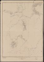
Description:
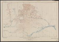
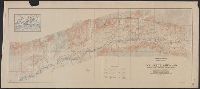
"Index map showing areas covered by topographic maps, August 1913"., "Recent survey publications" text on verso., Includes inset of the Aleutian Islands and chart of "Maps of Alaska for sale by U.S. Geological Survey.", and Relief shown by hachures and spot heights.
Publisher:
U.S. Geological Survey,
Subject (Geographic):
Alaska--Maps
Found in:
Beinecke Rare Book and Manuscript Library > Map of Alaska : compiled chiefly from maps of the U.S. Geological Survey / engraved and printed by the U.S. Geological Survey ; Alfred H. Brooks, Geologist in charge, Division of Alaskan Mineral Resources.
Creator:
Published / Created:
1913
Call Number:
848 K842 1913
Container / Volume:
BRBL_00633
Image Count:
1
Resource Type:
Maps, Atlases & Globes
Alternative Title:
Geological Survey bulletin. 532.
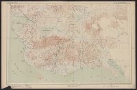
Description:
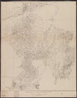
"Bulletin 532, plate I.", "Surveyed in 1899, 1901 and 1909.", and Relief shown by contours and spot heights.
Publisher:
Geological Survey,
Subject (Geographic):
Chandalar River Region (Alaska)--Maps and Koyukuk River Region (Alaska)--Maps
Subject (Name):
Brooks, Alfred H. (Alfred Hulse), 1871-1924 and Gerdine, T. G. (Thomas Golding), 1872-1930
Found in:
Beinecke Rare Book and Manuscript Library > Reconnaissance map of Koyukuk-Chandalar region, Alaska / U.S. Geological Survey ; Alfred H. Brooks, Geologist in charge of division, topography and triangulation by T.G. Gerdine ... [et al.].
Creator:
Published / Created:
1921
Call Number:
848 R82 1921
Container / Volume:
BRBL_00634
Image Count:
1
Resource Type:
Maps, Atlases & Globes
Alternative Title:
Ruby district, Alaska
Description:
Relief shown by contours and spot heights.
Publisher:
U.S. Geological Survey,
Subject (Geographic):
Nowitna National Wildlife Refuge (Alaska)--Maps, Nowitna River--Maps, and Ruby Region (Alaska)--Maps
Subject (Name):
Brooks, Alfred H. (Alfred Hulse), 1871-1924
Found in:
Beinecke Rare Book and Manuscript Library > Reconnaissance map of Ruby district, Alaska / U.S. Geoogical Survey; Alfred H. Brooks, geologist in charge of division.
Creator:
Published / Created:
1916
Call Number:
848 Y91 1916
Container / Volume:
BRBL_00634
Image Count:
1
Resource Type:
Maps, Atlases & Globes
Alternative Title:
Geological Survey bulletin. 631. and Yukon-Koyukuk region, Alaska
Description:
"U.S. Geological Survey bulletin 631, plate i." and Relief shown by contours and spot heights.
Publisher:
Geological Survey,
Subject (Geographic):
Koyukuk Region (Alaska)--Maps, Koyukuk River (Alaska)--Maps, Tanana Region (Alaska)--Maps, and Yukon-Koyukuk Census Area (Alaska)--Maps
Found in:
Beinecke Rare Book and Manuscript Library > Reconnaissance map of Yukon-Koyukuk region, Alaska / U.S. Geological Survey; Alfred H. Brooks, geologist in charge of division, topography by H.M. Eakin [et al].
Creator:
Published / Created:
1907
Call Number:
848 Se87 1907
Container / Volume:
BRBL_00634
Image Count:
1
Resource Type:
Maps, Atlases & Globes
Description:
"Surveyed in 1903; additional areas from surveys made in 1900 and 1901 by U.S. Geological Survey". and Relief shown by contours; contour interval 200 feet.
Publisher:
U.S.G.S.,
Subject (Geographic):
Seward Peninsula (Alaska)--Maps
Subject (Name):
Brooks, Alfred H. (Alfred Hulse), 1871-1924 and Witherspoon, D. C
Found in:
Beinecke Rare Book and Manuscript Library > Reconnaissance map of northeastern portion of Seward Peninsula Alaska / U.S. Geological Survey ; Alfred H. Brooks, geologist in charge ; D.C. Witherspoon, topographer ; C.E. Hill, field assistant.
Creator:
Published / Created:
1921
Call Number:
848 K96 1921
Container / Volume:
BRBL_00633
Image Count:
1
Resource Type:
Maps, Atlases & Globes
Alternative Title:
Lower Kuskokwim region, Alaska
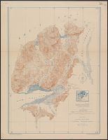
Description:
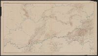
"Surveyed in 1898, 1914,1915,1916, and 1919.", Key map of surveyors' areas of responsiblity in margin., and Relief shown by contours, land forms and spot heights.
Publisher:
Geological Survey,
Subject (Geographic):
Kuskokwim Bay Region (Alaska)--Maps and Kuskokwim River Region (Alaska)--Maps
Subject (Name):
Brooks, Alfred H. (Alfred Hulse), 1871-1924, Maddren, A. G, Post, W. S, and Sargent, Rufus Harvey, b. 1875
Found in:
Beinecke Rare Book and Manuscript Library > Reconnaissance map of the Lower Kuskokwim region, Alaska / U.S. Geological Survey ; Alfred H. Brooks, Geologist in charge of division, topography by A.G. Maddren, R.H. Sargent and W.S. Post.
Creator:
Published / Created:
1907
Call Number:
848 Se87 1907A
Container / Volume:
BRBL_00634
Image Count:
1
Resource Type:
Maps, Atlases & Globes
Alternative Title:
Southern part of Seward Peninsula, Alaska
Description:
Ms. notes in red pencil "SEE CHART". and Relief shown by contours and spot heights.
Publisher:
Geological Survey,
Subject (Geographic):
Seward Peninsula (Alaska)--Maps
Subject (Name):
Barnard, E. C. (Edward Chester), 1863-1921, Hefty, J. G, and Reaburn, D. L
Found in:
Beinecke Rare Book and Manuscript Library > Reconnaissance map, southern part of Seward Peninsula, Alaska / topography by E.C. Barnard, D.L. Reaburn, J.G. Hefty ... [et al.].
Creator:
Published / Created:
1922
Call Number:
848 In5 1922
Container / Volume:
BRBL_00633
Image Count:
1
Resource Type:
Maps, Atlases & Globes
Alternative Title:
Iniskin-Chinitna Peninsula, Cook Inlet region, Alaska
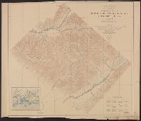
Description:
Includes inset location map., Relief shown by contours and spot heights., and Surveyed in 1921.
Publisher:
Geological Survey,
Subject (Geographic):
Chinitna Bay Region (Alaska)--Maps, Cook Inlet Region (Alaska)--Maps, and Iniskin Peninsula (Alaska)--Maps
Subject (Name):
Brooks, Alfred H. (Alfred Hulse), 1871-1924, FitzGerald, Gerald Arthur, 1899-, and McKinley, C. P
Found in:
Beinecke Rare Book and Manuscript Library > Topographic map of Iniskin-Chinitna Peninsula, Cook Inlet region, Alaska / United States Department of the Interior Geological Survey ; Alfred H. Brooks, geologist in charge of division ; topography by C.P. McKinley and Gerald Fitz-Gerald.
Creator:
Published / Created:
1922
Call Number:
848 K84 1922
Container / Volume:
BRBL_00633
Image Count:
1
Resource Type:
Maps, Atlases & Globes
Description:
"Alaska sheet no. 601 C.", "Survey in 1912-1913.", Includes location map., and Relief shown by contours and spot heights.
Publisher:
U.S. Geological Survey,
Subject (Topic):
Cordova-McCarthy Division (Alaska)--Maps
Found in:
Beinecke Rare Book and Manuscript Library > Topographic map of Kotsina-Kuskulana District, Copper River region, Alaska.
Creator:
Published / Created:
1918
Call Number:
848 M41 1918
Container / Volume:
BRBL_00634
Image Count:
1
Resource Type:
Maps, Atlases & Globes
Alternative Title:
Alaska ; 602 A and Lower Matanuska Valley, Alaska
Description:
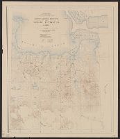
"Surveyed in 1909 and 1913 ; topography by Alaskan Branch, R.H. Sargent, topographic engineer.", Includes regional location map., and Relief shown by contours and spot heights.
Publisher:
The Survey,
Subject (Geographic):
Matanuska River Valley (Alaska)--Maps
Found in:
Beinecke Rare Book and Manuscript Library > Topographic map of Lower Matanuska Valley, Alaska / Department of the Interior, U.S. Geological Survey.
Branch:v1.61.6 ,Deployed:2024-06-12T09:55:37-04:00