Twenty four new and accurate maps of the several parts of Europe ... : all (except the last) new
Image Count:
1
Alternative Title:
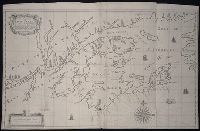
The English Channel; with the coasts of England, France, and Holland
Description:
In pencil on verso: 20. and Table of contents for maps 20-24 misnumbered.
Subject (Geographic):
Cevennes Mountains (France) --Maps, Dauphine´ Alps (France), England --Maps --To 1800, France --Maps --Early works to 1800, Lombardy (Italy) --Maps --Early works to 1800, Netherlands --Maps --Early works to 1800, and Provence-Alpes-Cote d'Azur (France) --Maps
Subject (Name):
Barker, B. (Benjamin), d. 1764, bookseller, Clements, Henry, d. 1719, bookseller, King, Charles, d. 1735, bookseller, Nicholson, John, d. ca. 1717, bookseller, Parker, Richard, fl. 1692-1725, bookseller, and Tooke, Benjamin, d. 1716, bookseller
Subject (Topic):
Atlases --Early works to 1800
Collection Created:
[London] : Sold by J. Nicholson at the King’s-Arms in Little Britain, Benj. Barker and Charles King ..., Benj. Tooke ..., Hen. Clements ..., R. Parker and Ralph Smith under the Royal-Exchange ..., [1715?]
Also appeared in Faden's [General atlas. London : William Faden, 1811?]., No. 10 of 43 maps bound together in composite atlas., Relief shown pictorially., and Scale [1: 510,000].
The discovery, settlement, and present state of Kentucky: and an essay towards the topography and
Image Count:
1
Description:
Engrav'd for S. Campbell's Edition of Imlay's Description of Kentucky., Preceding title page., and Teaching resource: Professor John Mack Faragher, History 141: The American West.
Subject (Geographic):
Kentucky --Maps --Early works to 1800 and Ohio River Valley
Map of all the world in two hemispheres in which are exactly described all the parts of the earth and seas
Description:
Dedicated To the most serene and most sacred majesty of Charles II ..., Described by Sanson ; corrected and amended by William Berry., Includes coat of arms and decorative cartouche containing dedication., No. 1 of 69 maps bound together in composite atlas., Prime meridian: Ferro., Relief shown pictorially., Scale [ca. 1:60 000 000]., and Shows California as an island.
Publisher:
Sold by William Berry at ye sign of the globe between Charing-Cross and White-Hall
Subject (Geographic):
Eastern Hemisphere --Maps --Early works to 1800 and Western Hemisphere --Maps --Early works to 1800
The English pilot: describing the sea-coasts, capes, head-lands, rivers, bays, roads, havens
Image Count:
1
Description:
Most maps numbered in pencil on verso, some on recto.
Subject (Geographic):
Atlantic Ocean --Maps --Early works to 1800, Canada --Maps --Early works to 1800, New England --Maps --Early works to 1800, Newfoundland and Labrador --Maps --Early works to 1800, and Nova Scotia --Maps --Early works to 1800
Subject (Topic):
Navigation --Early works to 1800, Pilot guides --Atlantic Coast (U.S.) --Early works to 1800, and Pilot guides --Caribbean Area --Early works to 1800
Collection Created:
London : Printed for John Thornton, at the sign of the England, Scotland, and Ireland, in the Minories, and Richard Mount, at the Postern on Tower-Hill, 1698London : Printed for John Thornton, at the sign of the England, Scotland, and Ireland, in the Minories, and Richard Mount, at the Postern on Tower-Hill, 1698
Chandos, James Brydges, Duke of, 1674-1744 Mayo, William., creator Senex, John, d. 1740
Published / Created:
1722
Call Number:
2003 Folio 85
Image Count:
1
Alternative Title:
New and exact map of the island of Barbadoes in America
Description:
BEIN 2003 Folio 85: No. 39 of 45 maps bound together with binder's spine title: Atlas of America; ms. table of contents. Bookplate: Robinson. Bookplate of Paul Mellon., by William Mayo., Cartouche with dedication to: The most high, puissant & noble prince, Iames Bruges, Duke of Chandos., Cartouche, Explanation, includes Contents of the parishes., Engraved by Iohn Senex, 1722., Hand colored., Insets: A plan of the Bridge town; A prospect of Codrington College &c., Relief shown pictorially., and Scale [ca. 1:33,000].