
You Searched For
« Previous
| 1 - 10 of 15 |
Next »
Search Results


- Creator:
- Homann Erben (Firm)
Homann, Johann Baptist, 1663-1724 - Published / Created:
- [1741?]
- Call Number:
- 1983 Folio 23
- Collection Title:
- [Atlas factice of 50 maps, primarily by Johann Baptist Homann and/or issued by the Homann Erben
- Image Count:
- 1
- Alternative Title:
- Allemagne distingue?e en ses cercles & subdivise?e en ses e?tats, contenant son e?tendue pre?sente rectifie?e & me?thodiquement enlumine?e suivant les e?le?ments de ge?ographie de Mr. Schatz a 1741 avec privilege imperial and Imperii Romano Germanici in suos status et circulos divisi tabula generalis
- Publisher:
- [Homann Erben?]
- Subject (Geographic):
- Austria --Maps --Early works to 1800, Czechoslovakia --Maps --Early works to 1800, Germany --Maps --Early works to 1800, Hungary --Maps --Early works to 1800, and Poland --Maps --Early works to 1800
- Collection Created:
- [Nuremberg : Homann Erben, 1710-1786]
- Found in:
- Beinecke Rare Book and Manuscript Library > Imperii Romano Germanici in svos statvs et circvlos divisi tabvla generalis in ufus iuventutis erundiendae accommodata

- Creator:
- Homann Erben (Firm)
Homann, Johann Baptist, 1663-1724 - Published / Created:
- [1746?]
- Call Number:
- 1973 Folio 30
- Collection Title:
- [Atlas factice of 32 maps and 1 distance table, produced by the Homann Erben firm]
- Image Count:
- 2
- Alternative Title:
- Allemagne distinguee en ses cercles & subdivisee en ses etats, contenant son etendue presente rectifiee & methodiquement enluminee suivant les elements de geographie de Mr. Schatz and Imperii Romano Germanici in suos status et circulos divisi tabula generalis
- Publisher:
- [Homann Erben?]
- Subject (Geographic):
- Austria --Maps --Early works to 1800, Czechoslovakia --Maps --Early works to 1800, Germany --Maps --Early works to 1800, Hungary --Maps --Early works to 1800, and Poland --Maps --Early works to 1800
- Subject (Topic):
- Atlases, German --Early works to 1800
- Collection Created:
- [Nuremberg : s.n.,
- Found in:
- Beinecke Rare Book and Manuscript Library > Imperii Romano Germanici in svos statvs et circvlos divisi tabvla generalis in ufus iuventutis erundiendae accommodata / [cartographic material] / a Ioh Bapt Homanno, S.C.M. Geographo, Reg. Boruss. Societ. Scient. Sodali

- Creator:
- Homann Erben (Firm)
Homann, Johann Baptist, 1663-1724 - Published / Created:
- ca. 1741
- Call Number:
- 1975 Folio 31
- Collection Title:
- [Atlas factice of 42 maps, produced by the Homann Erben firm]
- Image Count:
- 2
- Alternative Title:
- Allemagne distinguee en ses cercles & subdivisee en ses etats, contenant son etendue presente rectifiee & methodiquement enluminee suivant les elements de geographie de Mr. Schatz a 1741 avec privilege imperial and Imperii Romano Germanici in suos status et circulos divisi tabula generalis
- Publisher:
- Homann Erben?
- Subject (Geographic):
- Austria --Maps --Early works to 1800, Czechoslovakia --Maps --Early works to 1800, Germany --Maps --Early works to 1800, Hungary --Maps --Early works to 1800, and Poland --Maps --Early works to 1800
- Subject (Topic):
- Atlases, German --Early works to 1800
- Collection Created:
- [Nuremberg,
- Found in:
- Beinecke Rare Book and Manuscript Library > Imperii Romano Germanici in svos statvs et circvlos divisi tabvla generalis in ufus iuventutis erundiendae accommodata / a Ioh Bapt Homanno, S.C.M. Geographo, Reg. Boruss. Societ. Scient. Sodali
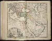
5.
- Creator:
- Hase, Johann Matthias, 1684-1742
Homann Erben (Firm)
Homann, Johann Baptist, 1663-1724 - Published / Created:
- [1737]
- Call Number:
- 1983 Folio 23
- Collection Title:
- [Atlas factice of 50 maps, primarily by Johann Baptist Homann and/or issued by the Homann Erben
- Image Count:
- 1
- Alternative Title:
- Tabula ex novissimus ad mentem de L'Islii, inprimis vero celeberrimi geographi Dni. I.M. Hasii, Prof. Vitemb. delineata a. 1737
- Description:
- Number 13 of 50 works bound together.
- Publisher:
- [Homann Erben]
- Subject (Geographic):
- Balkan Peninsula --Maps --Early works to 1800, Egypt --Maps --Early works to 1800, Libya --Maps --Early works to 1800, and Middle east --Maps --Early works to 1800
- Subject (Topic):
- Atlases --Early works to 1800
- Collection Created:
- [Nuremberg : Homann Erben, 1710-1786]
- Found in:
- Beinecke Rare Book and Manuscript Library > Imperium Turcicum in Europa, Asia et Africa regiones proprias, tributarias, clientelares sicut et omnes eusdem Beglirbegatus seu praefecturas generales exhibens [cartographic material] / sumptibus Io. Baptista Hommani
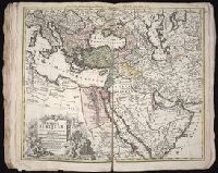
6.
- Creator:
- Hase, Johann Matthias, 1684-1742
Homann Erben (Firm)
Homann, Johann Baptist, 1663-1724 - Published / Created:
- 1737
- Call Number:
- 1975 Folio 31
- Collection Title:
- [Atlas factice of 42 maps, produced by the Homann Erben firm]
- Image Count:
- 1
- Alternative Title:
- Tabula ex novissimus ad mentem de L’Islii, inprimis vero celeberrimi geographi Dni. I.M. Hasii, Prof. Vitemb. delineata a. 1737
- Publisher:
- Homann Erben
- Subject (Geographic):
- Balkan Peninsula --Maps --Early works to 1800, Egypt --Maps --Early works to 1800, Libya --Maps --Early works to 1800, and Middle east --Maps --Early works to 1800
- Subject (Topic):
- Atlases, German --Early works to 1800
- Collection Created:
- [Nuremberg,
- Found in:
- Beinecke Rare Book and Manuscript Library > Imperium Turcicum in Europa, Asia et Africa regiones proprias, tributarias, clientelares sicut et omnes eusdem Beglirbegatus seu praefecturas generales exhibens [cartographic material] / sumptibus Io. Baptista Hommani
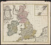
7.

- Creator:
- Homann Erben (Firm)
Homann, Johann Baptist, 1663-1724 - Published / Created:
- 1729
- Call Number:
- 1975 Folio 31
- Collection Title:
- [Atlas factice of 42 maps, produced by the Homann Erben firm]
- Image Count:
- 1
- Alternative Title:
- General map of Great Britain and Ireland with part of Holland, Flanders France &c. agreable to modern history by the heirs of late Mr. Homann at Nuremburg, priviledged by Emperours Majesty
- Publisher:
- Homann Erben
- Subject (Geographic):
- Great Britain --Maps --Early works to 1800 and Ireland --Maps --Early works to 1800
- Subject (Topic):
- Atlases, German --Early works to 1800
- Collection Created:
- [Nuremberg,
- Found in:
- Beinecke Rare Book and Manuscript Library > Magna Britannia complectens Angliae, Scotiae, et Hyberniae regn [cartographic material] : in suas prov. et comitat. divisa et ex mappis Londinensibus designata / per Homannum
8.
- Creator:
- Homann Erben (Firm)
Homann, Johann Baptist, 1663-1724 - Published / Created:
- ca. 1730]
- Call Number:
- 319 1720
- Container / Volume:
- BRBL_00040
- Image Count:
- 1
- Resource Type:
- Maps, Atlases & Globes
- Alternative Title:
- General map of Great Britain and Ireland with part of Holland, Flanders France &c. agreable to modern history by the heirs of late Mr. Homann at Nuremburg
- Description:
- Graphic scales given in "mill. Anglica" and "milliaria Germ.", Inset, top right: Orcades insulae ... Schetlandicae., Ornate title cartouche, top left, depicting coat of arms and flags., Relief shown pictorially., and Sheet measures 54.5 x 61.9 cm.
- Publisher:
- Homann Erben,
- Subject (Geographic):
- Great Britain--Maps--Early works to 1800 and Ireland--Maps--Early works to 1800
- Found in:
- Beinecke Rare Book and Manuscript Library > Magna Britannia complectens Angliae, Scotiae, et Hyberniae regn. : in suas prov. et comitat. divisa et ex mappis Londinensibus designata / per Homannianos heredes.
9.

- Creator:
- Homann Erben (Firm)
Homann, Johann Baptist, 1663-1724 - Published / Created:
- [ca. 1730]
- Call Number:
- 1983 Folio 23
- Collection Title:
- [Atlas factice of 50 maps, primarily by Johann Baptist Homann and/or issued by the Homann Erben
- Image Count:
- 1
- Alternative Title:
- General map of Great Britain and Ireland with part of Holland, Flanders France &c. agreable to modern history by the heirs of late Mr. Homann at Nuremburg
- Publisher:
- [Homann Erben]
- Subject (Geographic):
- Great Britain --Maps --Early works to 1800 and Ireland --Maps --Early works to 1800
- Collection Created:
- [Nuremberg : Homann Erben, 1710-1786]
- Found in:
- Beinecke Rare Book and Manuscript Library > Magna Britannia complectens Angliae, Scotiae, et Hyberniae regn. [cartographic material] : in suas prov. et comitat. divisa et ex mappis Londinensibus designata / per Homannianos heredes
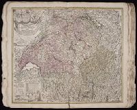
- Creator:
- Homann Erben (Firm)
Homann, Johann Baptist, 1663-1724 - Published / Created:
- 1732
- Call Number:
- 1975 Folio 31
- Collection Title:
- [Atlas factice of 42 maps, produced by the Homann Erben firm]
- Image Count:
- 1
- Alternative Title:
- Tabula ad geographiam Huebnerianam recentissime recognita nec minus passim auota et religionum simul distinctione illustrata per Homannianos Heredes anno 1732
- Publisher:
- [Homann Erben]
- Subject (Geographic):
- Switzerland --Maps --Early works to 1800
- Subject (Topic):
- Atlases, German --Early works to 1800
- Collection Created:
- [Nuremberg,
- Found in:
- Beinecke Rare Book and Manuscript Library > Potentissimae Helvetiorum Reipublicae cantones tredecim cum foederatis et subjectis provinciis / exhibiti a Ioh. Baptista Homanno