Bitovt wrongly combines this with the 1877 ed. of pt. 8; these 3 v. include pt. 8. Pts. 1-7, anda summary of pt. 8 pub. in Russkii vestnik, 1875-1877. and Russian in Cyrillic script.
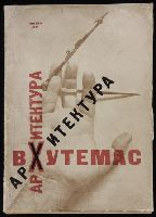
Dokuchaev, N Lissitzky, El, 1890-1941 Novit︠s︡kiĭ, P. (Pavel), b. 1888 VKhUTEMAS (Art school)
Published / Created:
1927
Call Number:
2009 +208
Image Count:
36
Description:
"Arkhitektura Vkhutemasa, Pavel Novitskiĭ:" p. [iii-iv]; "Arkhitekturnyĭ fakul’tet Vkhutemasa, N. Dokuchaev:" p. [v-xiv]; Cover design by El Lissitzky. and Imperfect: spine mutilated and repaired with facsimile work. Inscription: A. Aru[?], 1927. Original w
Publisher:
Izd-vo Vkhutemasa,
Subject (Topic):
Architecture and state --Soviet Union, Architecture --Soviet Union, Architecture --Soviet Union --Designs and plans, Architecture, Russian, Communism and architecture --Soviet Union, and Constructivism (
"Izvestiia Assotsiatsii novykh arkhitektorov, Mitteilungen der Assotiation neur Architekten, Revue de l'asotiation d'architectes contemporaine.", 1926., BEIN Eisenman Folio S10 1926: Imperfect: chipped and torn, with some loss of text. Accompanied by 3 reproductions and Dutch translation of issue., and Edited by El Lissitzky and N.A. Ladovsky.
Publisher:
[s.n.],
Subject (Name):
ASNOVA (Architecture group) and Lissitzky, El, 1890-1941.
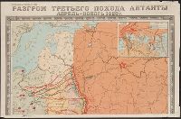
Egorova, L. N Soviet Union. Glavnoe upravlenie geodezii i kartografii
Published / Created:
1949
Call Number:
35hc 1922
Container / Volume:
BRBL_00103
Image Count:
4
Resource Type:
Maps, Atlases & Globes
Description:
"G-116.", Relief shown by shading., and Shows Soviet, White and Allied troop movements.
Publisher:
Glavnoe upravlenie geodezii i kartografii,
Subject (Geographic):
Russia (Territory under White armies, 1918-1920)--History--Maps, Soviet Union--History--Allied intervention, 1918-1920--Maps, and Soviet Union--History--Revolution, 1917-1921--Maps
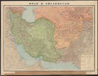
Institut ėtnografii imeni N.N. Miklukho-Maklai︠a︡ Институт этнографии имени Н.Н. Миклухо-Маклая
Published / Created:
1959
Call Number:
56ed 1959
Container / Volume:
BRBL_00298
Image Count:
2
Resource Type:
Maps, Atlases & Globes
Alternative Title:
Naselenie Kitai︠a︡, MNR i Korei. and Карта народов Китая, МНР и Кореи / составлена в 1958 г. Институтом этнографии имени Н.Н. Миклухо-Маклая Академии наук СССР и Научно-редакционной картосоставительской частью ГУГК ; под общим руководством П.Е. Терлецкого ; а
Description:
Accompanied by explanatory pamphlet with title: Naselenie Kitai︠a︡, MNR i Korei by S.I. Bruk., Accompanied by explanatory pamphlet with title: Население Китая, МНР и Кореи by S.I. Bruk., Legend also in Chinese., and Title from envelope in which issued.
Publisher:
Glavnoe upravlenie geodezii i kartografii MVD SSSR :, Institut ėtnografii imeni N.N. Miklukho-Maklai︠a︡ Akademii nauk SSSR,, Главное управление геодезии и картографии МВД СССР :, and Институт этнографии имени Н.Н. Миклухо-Маклая Академии наук СССР,
Subject (Geographic):
China--Maps, Korea--Maps, and Mongolia--Maps
Subject (Name):
Bruk, Solomon Ilʹich, Soviet Union. Glavnoe upravlenie geodezii i kartografii, Soviet Union. Главное управление геодезии и картографии, Terlet︠s︡kiĭ, P. E, Брук, Соломон Ильич, and Терлецкий, П. Е
Subject (Topic):
Ethnology--China--Maps, Ethnology--Korea--Maps, and Ethnology--Mongolia--Maps