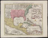
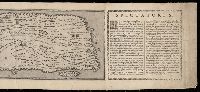
BEIN 85 1740D: Stamp on verso: Yale, Horace Brown, 1900S., BEIN 71 1737A: Forms part of the Benjamin Franklin Collection., Relief shown pictorially., "Cum gratia et privil S.R.I. Vicariatus in partibus Rheni Suevice et Juris Franconici.", Dates inferred from Portobelo inset showing "Admiralis Vernon Bachiam intrans d. 21 Novembr 1739" and reference in Lowery 328 to this map appearing as "... no. 190 in the 'Verlagsübersicht bis 1760', reprinted in Sandler's notice of Seutter.", and Includes insets of Portobelo, Havana, Cartagena, and Veracruz, text, and illustrations.
Publisher:
Tobias Conrad Seutter
Subject (Geographic):
North America, United States, Mexico, Central America, and Caribbean Area
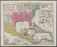
Relief shown pictorially., North oriented down., Bar scale given in unidenified units., Coordinates not present on map and are approximated., Includes index of colleges, buildings, and streets., and Insets: view of Oxforde and a map of Oxfordshire with bar scale in miles.
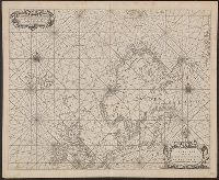
BEIN 21 1670A: Manuscript number on verso: 173. Watermark., Depths shown by isolines and soundings., Coordinates not present on map and are approximated., and From Blaeu's De groote Zee-spiegel (Amsterdam, 1655).
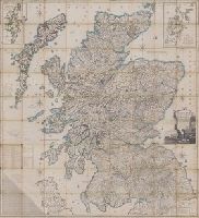
Scotland drawn and engraved from a series of angles and astronomical observations
Description:
Title from cartouche., Engraved throughout., Relief shown by contour lines and pictures., Scale of miles 69 1/2 to a degree., Another imprint: "Published according to Act of Parliament Jan. 1st. 1789 by John Ainslie ... and William Faden ..." at bottom of sheet., Inset maps: "Shetland Islands laid down upon a less scale than the map ... "; "A Map of the Orkney Islands ...", Distance tables and lists of heights of hills and roads from Edinburgh to London., Edinburgh meridian, with note of degrees from Greenwich., Title cartouche shows men fishing and herding cattle, with sheep goats and foliage., Six compass roses., This issue not in Chubb, T. Printed maps in the atlases of Great Britain and Ireland., and Scotland.
Publisher:
Printed and sold by the proprietor Thomas Brown, North Bridge Street, Edinburgh and Publish'd according to Act of Parliament with improvements till 1800 by Thomas Brown ... Edinburgh and William Faden ... London
Subject (Geographic):
Scotland, Orkney (Scotland), Shetland (Scotland), Scotland., Orkney., and Shetland.
Peutinger table and Tabvla itineraria ex illvstri Pevtingerorvm Bibliotheca
Description:
BEIN 2016 +333: Imperfect: title panel mutilated, with some loss of text. Sheets joined together to form a roll; backed in linen., Relief shown pictorially., "MD" in publication date in apostrophic forms., Appears in Ortelius' Theatri Orbis Terrarum Parergon. Antwerp, 1624., and "Peutinger Table: Road map of Western Roman Empire about 250 A.D. bought by Conrad Peutinger and published in Venice by Aldus in 1591 (2 sections only), in Antwerp 1598 (12 sections) ... The only record of Roman map making that has survived to the present day."--Tooley's Dictionary of Mapmakers. New York, 1979.
Title devised by cataloger., "Vinc[enti]us demetrei Volcius Rachuseus. Fecit interra Liiburni die 24 Maius 1601.", With blue cloth tie at left edge., Color: red, blue, and some gold., With four compass roses., and Coordinates not present on map and are approximated.