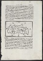
Appears in Bordon's Libro di Benedetto Bordone nel qual si ragiona de tutte l'isole del mondo. 1528., Ciampagu oriented with north to the right. Iava Maggiore, Sondur, and Condur oriented with north toward the lower right., and Covers Japan, depicted as one isl
Publisher:
Nicolo d'Aristotile, detto Zoppino,
Subject (Geographic):
Japan--Maps--Early works to 1800 and Java (Indonesia)--Maps--Early works to 1800
Subject (Name):
Bordon, Benedetto, 1450-1530. Libro di Benedetto Bordone nel qual si ragiona de tutte l'isole del mondo and Zoppino, Nicolò, fl. 1508-1544
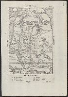
Appears in the author's Delle navigationi et viaggi., Covers Africa, except for the western bulge and southern tip., Has watermark., Includes text on verso., Oriented with north to the bottom., Pg. no. in upper right margin: 261., Relief shown pictorially., and Titl
Publisher:
G.B. Ramusio,
Subject (Geographic):
Africa--Maps--Early works to 1800
Subject (Name):
Ramusio, Giovanni Battista, 1485-1557. Delle navigationi et viaggi
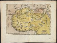
Qazwīnī, Zakarīyā ibn Muḥammad, 1208 or 9-1283 or 4.
Published / Created:
[15--?]
Call Number:
Arabic MSS 575
Image Count:
2
Resource Type:
Maps, Atlases & Globes
Abstract:
In the center of the map is Mecca; the ocean is located on each side along the outer edge of the sheet with the pillars of the earth in the four corners. Great emphasis is placed on Africa and the Nile river. Other places of interest include: Wasteland where nobody lives, Mountains of the Moon, Land of the Slavs and Franks, Gog and Magog, Land of the Turks (Central Asia), Red Sea (rectangular water mass), the Source of life.
Description:
Gift of Thomas E. Marston, Yale '27, in honor of Alexander O. Vietor, Yale '36, in November 1978., Removed from a bound volume., and Tempera and ink.
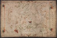
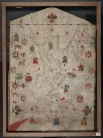
Colors: red, greens, and blues., Crucifix at top of map., Inset: The world., Joan Riezo figlo de mastro dominico [Olives] in missina año 1590., and Notes: gold ribbon along borders of map, missing from far right hand side.
Subject (Geographic):
Europe--Maps--Early works to 1800 and Mediterranean Sea--Maps--Early works to 1800
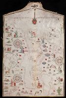
Contains seven compass roses., Decoration: city views with banners; Jesus Christ on a cross at left edge., Label on verso: Vend. del 4.VI.32-X., Pen-and-ink in black, red, blue and green., Portolan chart with seaport names given for all coastlines., and Title devised by cataloger.
Subject (Geographic):
Black Sea--Maps--Early works to 1800. and Mediterranean Sea--Maps--Early works to 1800.
Subject (Topic):
Nautical charts--Black Sea--Early works to 1800. and Nautical charts--Mediterranean Sea--Early works to 1800.
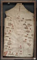
Contains five compass roses., Decoration: city views with banners, animals, eight cherubs blowing winds, and Virgin Mary with child (on left edge)., Includes two islands in the North Atlantic "Stilanda" and "Frixlanda.", Pen-and-ink in black, red, blue and green., Portolan chart with seaport names given for all coastlines., and Title devised by cataloger.
Subject (Geographic):
Baltic Sea--Maps--Early works to 1800., Mediterranean Sea--Maps--Early works to 1800., and North Atlantic Ocean--Maps--Early works to 1800.
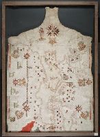
Contains eleven compass roses., Decoration: city views with banners, figures sitting on thrones, holding swords and armorial shields; animals; three fleur-de-lis., Imperfect: chipped along bottom edge, with some loss of map., Includes degrees of latitude along left edge: 25°N to 65°N., Pen-and-ink in black, red, blue and green., Portolan chart with seaport names given for all coastlines., and Title devised by cataloger.
Subject (Geographic):
Black Sea--Maps--Early works to 1800., Mediterranean Sea--Maps--Early works to 1800., and North Atlantic Ocean--Maps--Early works to 1800.
Subject (Topic):
Nautical charts--Black Sea--Early works to 1800., Nautical charts--Mediterranean Sea--Early works to 1800., and Nautical charts--North Atlantic Ocean--Early works to 1800.