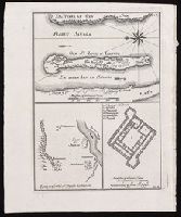
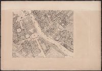
[Top] Chart of the island of Saint Louis showing location of the Fort St. Louis, the reservoir, and dwellings in western Africa; [bottom left] Chart of the location of Fort St. Joseph in Bakel, Senegal, on the Senegal River; [bottom right] Plan of the Fort St. Joseph.
Alternative Title:
Egnen fra fortet St. Joseph til Galam and Grundridsning of fortet St. Joseph
Description:
"No. 14" in upper right corner; "III.D." in lower right corner., Coordinates not present on map and are approximated., From Almindelig histoirie over reiser til lands og bands ... (Kjøbenhavn: Niels Hansen Møller, 1749), a translation of Collection of voyages and travels edited by Awnsham Chruchill and Thomas Osborne., North oriented towards the left on first map., Relief shown pictorially., and Title of first map devised by cataloger.
Publisher:
[Niels Hansen Møller],
Subject (Geographic):
Bakel (Senegal : Department)--Maps--Early works to 1800. and Saint-Louis (Senegal)--Maps--Early works to 1800.
Subject (Name):
Churchill, Awnsham, -1728. Collection of voyages and travels. Danish., Møller, Niels Hansen, and Osborne, Thomas, -1767. Collection of voyages and travels. Danish.
An issue of the Pownall map of North America and the West Indies; appears similar to the 1783 and 1794 editions., Insets: A particular map of Baffin and Hudson's Bay -- The passage by land to California., Prime meridians: London and Ferro., and Relief shown pict
American N.W. Coast is not continued (except in a dotted line) North of California, and no mention is made of Bering's discoveries. and Preliminary record.
Des Barres, Joseph F. W. (Joseph Frederick Wallet), 1722-1824
Published / Created:
1775?-1781?]
Call Number:
1983 Folio 25
Image Count:
3
Resource Type:
Maps, Atlases & Globes
Abstract:
A made-up collection of charts, plans and views, partly hand colored, from the Atlantic Neptune comprising [v. 1]: the charts of the South East Coast of Nova Scotia, with the title page of The charts of the coast and harbors of New England, 1781 bound in front (31 items, dated between 1777 and 1781). [v. 2]: Charts of the coast and harbours in the Gulph and river of St. Lawrence, 1780, including the charts of the coast of New England (36 items, dated between 1775 and 1781). [v. 3]: Charts of several harbours and divers parts of the coast of North America from New York south westwards to the Gulph of Mexico, 1780, including some 16 charts belonging to the New England part of the work (35 items, dated between 1776 and 1781). General title page wanting.
Description:
Includes indexes.
Publisher:
The Admiralty,
Subject (Geographic):
North America--Maps and North America--Pictorial works
"Nota" with details of changes in positions during the siege., Inset: "Explication des lettres du plan.", Map shows fortifications around the city, the positions of the French, American and British batteries, roads to surrounding towns, and the Savannah and Augustine rivers., Pen and ink ms. signed "O'Connor"., and Title supplied by cataloger.
Subject (Geographic):
Savannah (Ga.)--History--Siege, 1779--Maps, Manuscript--Early works to 1800 and Savannah (Ga.)--Maps, Manuscript--Early works to 1800