Title from item., Publication date from an unverified card catalog record, based on the date of the Battle of Minorca, but possibly later., and Temporary local subject terms: Battles: reference to the Battle of Minorca, July 1756 -- Military uniforms: Lieutenant-General of Minorca -- Monuments.
Publisher:
Se hallara en la Librria de Dn Miguel Copin, carrra de Sn. Geronimo, en Madrid
Subject (Name):
Richelieu, Louis François Armand Du Plessis, duc de, 1696-1788,
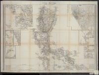
BEIN 28 1852A: Covers removed and classed separately as 28 1852AA. Bookseller's label on inside front cover: Cellar Book Shop ... Detroit, Mich., BEIN 28 1852B: Covers removed and classed separately as 28 1852BA. Bookseller's label on inside front cover: Cellar Book Shop ... Detroit, Mich., BEIN 28 1852C: Covers removed and classed separately as 28 1852CA. Bookseller's label on inside front cover: Cellar Book Shop ... Detroit, Mich., Relief shown by hachures. Depths shown by soundings., Prime meridian: Madrid., In upper margin: Diccionario geográfico-estadístico-histórico ; Atlas de España y sus posesiones de ultramar., Cover title: Atlas de España y sus posesiones de ultramar / por D. Francisco Coello., Sheets titled: Posesiones de Oceania -- Primera hoja central -- Segunda hoja central., "Grabado en Madrid bajo la direccion de D. Juan Noguera. El contorno y la topografia por Desbuissons y Raynaud, la letra por Bacot"--Primera hoja., "Grabado en Madrid bajo la direccion del autor. El contorno por Leclercq, la topografia por Desbuissons, la letra por Bacot"--Segunda hoja and posesiones sheet., Includes text about demography and economy., and Price and subscription information on covers.
Cruz Cano y Olmedilla, Juan de la, d. 1790 Lopez de Vargas Machuca, Tomas, 1731-1802, creator
Published / Created:
1755
Call Number:
2003 Folio 85
Image Count:
1
Description:
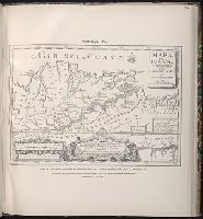
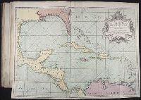
Available also through the Library of Congress Web site as a raster image., BEIN 2003 Folio 85: No. 27 of 45 maps bound together with binder's spine title: Atlas of America; ms. table of contents. Bookplate: Robinson. Bookplate of Paul Mellon., Dedicado a la Catholica Magestad de Don Fernando VI Rey de Espana, y de las Yndias, por sus mas rendidos, y fieles vasallos, Thomas Lopez, y Juan de la Cruz., Depths shown by soundings., Hand colored., LC Maps of North America, 1750-1789,, Longitud ocidental del meridiano de Tenerife., and Scale [ca. 1:5,500,000].
Subject (Geographic):
Caribbean Area -- Maps -- Early works to 1800
Subject (Topic):
Nautical charts -- Caribbean Area -- Early works to 1800