Manuscript on parchment of an outline map of Europe, Africa, Asia, the surrounding seas and the islands including Iceland, Greenland, and "Vinland," which resembles the coastline of northern North America, with identifying legends. Known as the "Vinland Map," at the time it was acquired by Yale it was considered to be the earliest European map of any portion of the Western Hemisphere. The authenticity of the map was the subject of considerable debate for decades. Extensive scientific testing sponsored by Yale University in 2021, conclusively demonstrated that the map is a modern forgery and Originally the Vinland Map, Speculum historiale (Beinecke MS 350), and Hystoria Tartarorum (Beinecke MS 350A.1) were bound together in that order in a single volume, as is indicated by the patterns of the wormholes
All volumes bound to match 1973 Folio 72. Factitious collection of about 549 maps taken from the atlases of the 17th and the beginning of the 18th cent., put together with the title "Atlas" and bound in 6 volumes. These volumes originally bore the imprint: Amstelaedamii apvd Reiniervm & Josvam Ottens. Over these words on the title-pages of v. 1-2, 4-6 is the name of Henrik de Leth who painted them. Volume 3 has only the erased imprint of Ottens., For fuller description see Phillips 3448 and C. Koeman's Atlantes Neerlandici, bibliography of terrestrial, maritime and celestial atlases and pilot books, published in the Netherlands up to 1800, Amsterdam c1967-71, v. 2, p. 63-83., and Maps by P. Schenck and son, G. Valck, F. de Wit, N. Visscher and others.
Publisher:
chez J. Covens & C. Mortier,
Subject (Geographic):
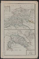
Denmark --Maps --Early works to 1800
Subject (Name):
Reiner et Josua Ottens (Firm), Schenk, Peter, 1660-1718 or 1719., and Valck, G. (Gerard), 1651 or 1652-1726.
Harding, G. P. (George Perfect), 1780-1853, artist
Published / Created:
[not after 1824]
Call Number:
Folio 33 30 Copy 4
Image Count:
1
Resource Type:
still image
Abstract:
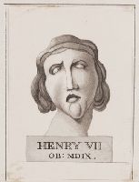
Wash drawing depicting the stone bust of Henry VII, supposedly a model for his tomb designed by Torrigiano, that was kept by Horace Walpole in the Star Chamber at Strawberry Hill
Alternative Title:
Henry VII OB: MDIX
Description:
Title devised by curator., Written in ink within pedestal at bottom of image: Henry VII OB: MDIX., Unsigned; questionable attribution to George Perfect Harding from local card catalog record., Date based on date of William Bawtree's death., and Mounted on page 105 of William Bawtree's extra-illustrated copy of: Horace Walpole's A description of the villa of Mr. Horace Walpole (Strawberry Hill : Printed by Thomas Kirgate, 1784). See A.T. Hazen's Bibliography of the Strawberry Hill Press (1973 ed.), no. 30, copy 11.
Subject (Name):
Henry VII, King of England, 1457-1509, and Strawberry Hill (Twickenham, London, England)
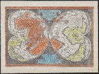
"Ne que ad nos Fram orbis ... Cappadocie 7.", "Quam hic vides orbis imagine lector cadide ... Vale 1538", Cordiform map of the world, 1538, Joanni Drosio suo Gerardus Rupelmudan deducabat., Map of the world, 1538, Orbis imago., and World map on double cordiform pro
Description:
Also known as World map on double cordiform projection and Orbis imago., Cross collection no. 4., Facsimile of Gerhard Mercator's first world map, published in Louvain, 1538., Relief shown pictorially., and Title from another facsimile published by the New York Public Library.
Publisher:
Julius Bien & Co., photo-lith,
Subject (Name):
Brevoort, James Carson, 1818-1887 and Julius Bien & Co
Subject (Topic):
Early maps--Facsimiles and World maps--Early works to 1800--Facsimiles