Search
You Searched For
Search Results
- Creator:
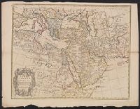
- L'Isle, Guillaume de, 1675-1726
- Published / Created:
- 1711
- Call Number:
- 53 1711
- Container / Volume:
- BRBL_00684
- Image Count:
- 1
- Resource Type:
- Maps, Atlases & Globes
- Found in:
- Beinecke Rare Book and Manuscript Library > A map of Turky [sic] Arabia & Persia : corrected from the latest travels and from the observations of the Royal Societys of London and Paris / by G. De L'Isle.
- Creator:
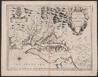
- Speed, John, 1552?-1629
- Published / Created:
- [1676]
- Call Number:
- 783 1680
- Container / Volume:
- BRBL_00691
- Image Count:
- 2
- Resource Type:
- Maps, Atlases & Globes
- Found in:
- Beinecke Rare Book and Manuscript Library > A map of Virginia and Maryland / F. Lamb sculp.
- Creator:
- Speed, John, 1552?-1629
- Published / Created:
- [1676]
- Call Number:
- 755 1676D
- Container / Volume:
- BRBL_00423
- Image Count:
- 2
- Resource Type:
- Maps, Atlases & Globes
- Found in:
- Beinecke Rare Book and Manuscript Library > A map of Virginia and Maryland / F. Lamb sculp.
- Published / Created:
- 1805
- Call Number:
- 3253 1805
- Container / Volume:
- BRBL_00067
- Image Count:
- 1
- Resource Type:
- Maps, Atlases & Globes
- Found in:
- Beinecke Rare Book and Manuscript Library > A map of Westmoreland ... Engraved by J. Cary.
- Creator:
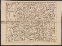
- Senex, John, d. 1740
- Published / Created:
- [1710]
- Call Number:
- 392 1710
- Container / Volume:
- BRBL_00684
- Image Count:
- 1
- Resource Type:
- Maps, Atlases & Globes
- Found in:
- Beinecke Rare Book and Manuscript Library > A map of old & new Castile : from the observations of Rodrigo Mendes Silva and others.
- Creator:
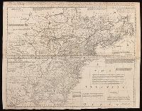
- Bowen, Thomas, -1790
- Published / Created:
- 1755]
- Call Number:
- BrSides Folio 2019 104
- Image Count:
- 1
- Resource Type:
- Maps, Atlases & Globes
- Found in:
- Beinecke Rare Book and Manuscript Library > A map of the British and French settlements in North America / T. Bowen, sculpt.
- Creator:
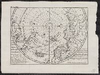
- Moll, Herman, -1732
- Published / Created:
- [1736?]
- Call Number:
- 18 1739
- Container / Volume:
- BRBL_00682
- Image Count:
- 1
- Resource Type:
- Maps, Atlases & Globes
- Found in:
- Beinecke Rare Book and Manuscript Library > A map of the North Pole : with all the territories that lye near it, known to us &c. : according to the latest discoveries, and most exact observations : agreeable to modern history / by H. Moll geographer.
- Creator:
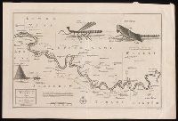
- Leach, John, Captain
- Published / Created:
- [approximately 1745]
- Call Number:
- BrSides 2019 87
- Image Count:
- 1
- Resource Type:
- Maps, Atlases & Globes
- Found in:
- Beinecke Rare Book and Manuscript Library > A map of the River Gambra from Eropina to Barrakunda / by Captn. John Leach in 1732 ; Thos. Kitchin sculpt.
- Published / Created:
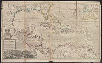
- [1720?]
- Call Number:
- 85 1720
- Container / Volume:
- BRBL_00636
- Image Count:
- 1
- Resource Type:
- Maps, Atlases & Globes
- Found in:
- Beinecke Rare Book and Manuscript Library > A map of the West Indies or the Islands of America ... explaining what belongs to Spain, England, France, Holland & c. also ye trade winds ...
- Published / Created:
- [1720?]
- Call Number:
- 85 1720
- Container / Volume:
- BRBL_00636
- Image Count:
- 1
- Resource Type:
- Maps, Atlases & Globes
- Found in:
- Beinecke Rare Book and Manuscript Library > A map of the West Indies or the Islands of America ... explaining what belongs to Spain, England, France, Holland & c. also ye trade winds ...