Skip to search
Skip to main content
Skip to first result
Search
You Searched For
Date
Unknown
Genre
Maps in books
Language
English
Date Created
[Missing]
New Search
Search Results
Creator:
Call Number:
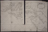
1973 Folio 76
Collection Title:
The English pilot: describing the sea-coasts, capes, head-lands, rivers, bays, roads, havens
Image Count:
1
Description:
Most maps numbered in pencil on verso, some on recto.
Subject (Geographic):
Atlantic Ocean --Maps --Early works to 1800, Maryland --Maps --Early works to 1800, New Jersey --Maps --Early works to 1800, and Virginia --Maps --Early works to 1800
Subject (Topic):
Navigation --Early works to 1800, Pilot guides --Atlantic Coast (U.S.) --Early works to 1800, and Pilot guides --Caribbean Area --Early works to 1800
Collection Created:
London : Printed for John Thornton, at the sign of the England, Scotland, and Ireland, in the Minories, and Richard Mount, at the Postern on Tower-Hill, 1698London : Printed for John Thornton, at the sign of the England, Scotland, and Ireland, in the Minories, and Richard Mount, at the Postern on Tower-Hill, 1698
Found in:
Beinecke Rare Book and Manuscript Library > Virginia, Maryland, Pennsilvania, east & west New Jarsey
Call Number:
Zc20 802crc
Collection Title:
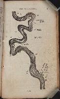
The navigator; or, The traders' useful guide in navigating the Monongahela, Allegheny, Ohio, and
Image Count:
1
Description:
P. 55.
Subject (Geographic):
Chickasaw Bluffs (Tenn.), Mississippi River --Description and travel, Mississippi River --Maps, Mississippi River --Navigation, and Tennessee
Collection Created:
Pittsburgh, From the Press of Zadok Cramer, 1806
Found in:
Beinecke Rare Book and Manuscript Library > [A portion of the Mississippi River, including Chickasaw Bluffs]
Call Number:
Zc20 802crc
Collection Title:
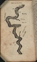
The navigator; or, The traders' useful guide in navigating the Monongahela, Allegheny, Ohio, and
Image Count:
1
Description:
P. 72.
Subject (Geographic):
Mississippi, Mississippi River --Description and travel, Mississippi River --Maps, Mississippi River --Navigation, and Natchez (Miss.)
Collection Created:
Pittsburgh, From the Press of Zadok Cramer, 1806
Found in:
Beinecke Rare Book and Manuscript Library > [A portion of the Mississippi River, including Natchez]
Creator:
Published / Created:
Undated
Call Number:
Taylor 216A
Collection Title:
Iohn Huighen van Linschoten, his Discours of Voyages into ye Easte & West Indies : deuided into
Image Count:
1
Description:
Bound in following title page of second book. and Map has small tear at bottom fold in center.
Subject (Geographic):
Africa --Maps --Early works to 1800, Cape of Good Hope --Maps, Congo (Democratic Republic) --Maps, and Madagascar --Maps --Early works to 1800
Subject (Name):
Wolfe, John, d. 1601, printer
Subject (Topic):
Voyages and travels --Early works to 1800
Collection Created:
[London] : Printed at London by [John Windet for] Iohn Wolfe, printer to ye Honorable Cittie of London, [1598]
Found in:
Beinecke Rare Book and Manuscript Library > [Map of southern Africa and Madagascar]
Call Number:
Lxe 784m
Collection Title:
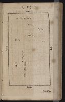
Geography made easy : being a short, but comprehensive system of that very useful and agreeable
Image Count:
1
Resource Type:
Books, Journals & Pamphlets
Description:
Imperfect: engraving of map not completed.
Subject (Name):
Doolittle, Amos, 1754-1832
Subject (Topic):
Geography
Collection Created:
New Haven : Meigs, Bowen & Dana, [1784]
Found in:
Beinecke Rare Book and Manuscript Library > [Placement of the divisions of South America]
Call Number:
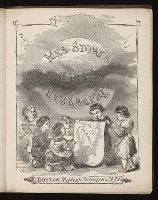
Za St78 855f
Collection Title:
First geography for children / by Mrs. Harriet Beecher Stowe
Image Count:
9
Resource Type:
Books, Journals & Pamphlets
Subject (Geographic):
Africa
Subject (Topic):
Geography --Textbooks, Slavery, and Slaves --Social conditions
Collection Created:
Boston : Phillips, Sampson, and Co. ; New York : J.C. Derby, 1855
Found in:
Beinecke Rare Book and Manuscript Library > [Selected pages]
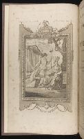
Call Number:
MMLm143 778bc
Collection Title:
The self-interpreting Bible: containing the sacred text of the Old and New Testaments. Translated
Image Count:
5
Description:
Binder’s title: Brown’s Bible. and Includes bound in map of the Holy Land (folded) 42 x 24 cm.
Subject (Topic):
Bible. O.T. and Palestine--Maps--Early works to 1800
Collection Created:
New-York : Printed by Hodge and Campbell, and sold at their respective book stores, M.DCC.XCII
Found in:
Beinecke Rare Book and Manuscript Library > [Selected pages]
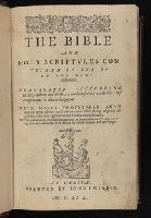
Call Number:
1977 1310
Collection Title:
The Bible : that is, The Holy Scriptures conteined in the Olde and Newe Testament / translated
Image Count:
9
Description:
Bound with: Sternhold, Thomas. The whole book of Psalmes. [London, 1599] and the Apocrypha. and Red lined throughout.
Subject (Geographic):
Eden--Early works to 1800 and Palestine--Maps--Early works to 1800
Subject (Topic):
Exodus, The--Maps
Collection Created:
Imprinted at London : By the deputies of Christopher Barker, printer to the Queenes most excellent Maiestie, 1599
Found in:
Beinecke Rare Book and Manuscript Library > [Title and selected pages]
Call Number:
1997 1451
Collection Title:
The Bible and Holy Scriptures conteyned in the Olde and Newe Testament / translated according to
Image Count:
2
Subject (Geographic):
Eden--Early works to 1800, Middle East--Maps--Early works to 1800, and Palestine--Maps--Early works to 1800
Collection Created:
At Geneua : Printed by Iohn Crispin, M.D.LXX. [1570]
Found in:
Beinecke Rare Book and Manuscript Library > [Title and selected pages]
Branch:v1.61.8 ,Deployed:2024-06-20T11:14:55-04:00