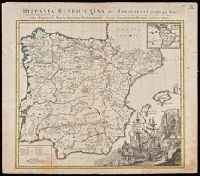
Illustrated cartouche., Includes inset: "America Benedictina"., Relief shown pictorially., and Watermark. Manuscript number "12" in upper right corner. From the Karpinski-von Wieser Map Collection.
Publisher:
Impensis Homannianorum Heredum
Subject (Geographic):
Europe--Iberian Peninsula, Iberian Peninsula--Maps--Early works to 1800., Portugal, Portugal--Maps--Early works to 1800., Spain, and Spain--Maps--Early works to 1800.
Subject (Name):
Benedictines, Benedictines--Iberian Peninsula--Maps--Early works to 1800, Benedictines--Portugal--Maps--Early works to 1800, Benedictines--Spain--Maps--Early works to 1800, Catholic C, and Catholic Church
Homann Erben (Firm) Homann, Johann Baptist, 1663-1724
Published / Created:
[1741?]
Call Number:
1983 Folio 23
Collection Title:
[Atlas factice of 50 maps, primarily by Johann Baptist Homann and/or issued by the Homann Erben
Image Count:
1
Alternative Title:
Allemagne distingue?e en ses cercles & subdivise?e en ses e?tats, contenant son e?tendue pre?sente rectifie?e & me?thodiquement enlumine?e suivant les e?le?ments de ge?ographie de Mr. Schatz a 1741 avec privilege imperial and Imperii Romano Germanici in suos status et circulos divisi tabula generalis
Publisher:
[Homann Erben?]
Subject (Geographic):
Austria --Maps --Early works to 1800, Czechoslovakia --Maps --Early works to 1800, Germany --Maps --Early works to 1800, Hungary --Maps --Early works to 1800, and Poland --Maps --Early works to 1800
Homann Erben (Firm) Homann, Johann Baptist, 1663-1724
Published / Created:
[1746?]
Call Number:
1973 Folio 30
Collection Title:
[Atlas factice of 32 maps and 1 distance table, produced by the Homann Erben firm]
Image Count:
2
Alternative Title:
Allemagne distinguee en ses cercles & subdivisee en ses etats, contenant son etendue presente rectifiee & methodiquement enluminee suivant les elements de geographie de Mr. Schatz and Imperii Romano Germanici in suos status et circulos divisi tabula generalis
Publisher:
[Homann Erben?]
Subject (Geographic):
Austria --Maps --Early works to 1800, Czechoslovakia --Maps --Early works to 1800, Germany --Maps --Early works to 1800, Hungary --Maps --Early works to 1800, and Poland --Maps --Early works to 1800
Homann Erben (Firm) Homann, Johann Baptist, 1663-1724
Published / Created:
ca. 1741
Call Number:
1975 Folio 31
Collection Title:
[Atlas factice of 42 maps, produced by the Homann Erben firm]
Image Count:
2
Alternative Title:
Allemagne distinguee en ses cercles & subdivisee en ses etats, contenant son etendue presente rectifiee & methodiquement enluminee suivant les elements de geographie de Mr. Schatz a 1741 avec privilege imperial and Imperii Romano Germanici in suos status et circulos divisi tabula generalis
Publisher:
Homann Erben?
Subject (Geographic):
Austria --Maps --Early works to 1800, Czechoslovakia --Maps --Early works to 1800, Germany --Maps --Early works to 1800, Hungary --Maps --Early works to 1800, and Poland --Maps --Early works to 1800
[Atlas factice of 32 maps and 1 distance table, produced by the Homann Erben firm]
Image Count:
2
Alternative Title:
Carte des etats de la Covronne de Pologne
Publisher:
Luci publicae tradita per Homannianos Heredes
Subject (Geographic):
Belarus --Maps --Early works to 1800, Lithuania --Maps --Early works to 1800, Poland --Maps --Early works to 1800, and Ukraine --Maps --Early works to 1800
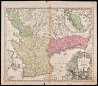
"Cum Privilegio Sac. Caes. Maj.", Inset in upper right margin shows continuation of Halland., Relief shown pictorially., and Watermark. Manuscript number in upper right corner. Manuscript waste pasted to verso. From the Karpinski-von Wieser Map Collection.
Publisher:
[Johann Baptist Homann]
Subject (Geographic):
Blekinge län (Sweden)--Maps--Early works to 1800., Hallands län (Sweden)--Maps--Early works to 1800., Skåne (Sweden)--Maps--Early works to 1800., Sweden--Blekinge län, Sweden--Hallands län, and Sweden--Ma
[Atlas factice of 42 maps, produced by the Homann Erben firm]
Image Count:
2
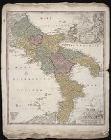
Alternative Title:
Novissima & exactissima totius regni Neapolis tabula, Novissima and exactissima totius regni Neapolis tabula, and Novissima and exactissima totivs regni Neapolis tabvla
Publisher:
Johann Baptist Homann
Subject (Geographic):
Naples (Italy : Province) --Maps --Early works to 1800 and Naples (Kingdom) --Maps --Early works to 1800