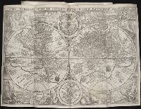
Plancius, Petrus, 1552-1622. Orbis terrarum typus de integro multis in locis emendatus
Published / Created:
1594
Call Number:
Taylor 219
Collection Title:
Navigatio ac itinerarivm Iohannis Hvgonis Linscotani in Orientalem sive Lvsitanorvm Indiam
Image Count:
1
Abstract:
Major land masses known at the time are depicted in the corners of the map with representative fauna and flora as well as the people indigenous to those areas and their activities. Two astrological charts are positioned in the center, above and below the two hemispheres.
Alternative Title:
Orbis terrarum typus de integro multis in locis emendatus
Description:
[Scale ca. 1:45,000,000]., Bound in following page 4., and Map is torn in several areas and has been backed with another sheet of paper.
Subject (Geographic):
World maps --Early works to 1800
Subject (Name):
Claesz, Cornelis, ca. 1546-1609, publisher, Elzevier, Gillis, bookseller, Hendricksz, Aelbrecht, fl. 1573-1605, printer, and Langren, Arnold Florent van, 1580-1644
Subject (Topic):
Voyages and travels --Early works to 1800
Collection Created:
Hagae-Comitis : Ex officina Alberti Henrici, impensis authoris & Cornelii Nicolai, prostantque apud Aegidium Elseuirum, anno 1599
Descriptio ac delineatio geographica detectionis freti, sive, transitus ad occasum supra terras
Image Count:
1
Abstract:
Map depicts the Coat of Arms of the United Kingdom (era of the Union of the Crowns), reigning between the years 1603-1707.
Alternative Title:
Tabula nautica ...
Description:
Bound in after p. [6]., In ink on recto: place names "Okkak", "Nain"[?] and one longer handwritten note on the bottom margin., Map cut and folded irregularly., Map has been repaired with multiple pieces of tape on verso., Map has multiple small stains on both the recto and verso., Printed on recto in lower right corner: A1., and Scale [ca. 1:9,000,000].
Subject (Geographic):
North Atlantic Ocean --Maps --Early works to 1800
Subject (Name):
Hudson, Henry, d. 1611
Collection Created:
Amsterodami Ex officina Hesse lij Gerardi. Anno 1613
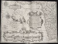
Regnum Congo hoc est vera descriptio regni Africani : quod tam ab incolis quam Lusitanis Congus
Image Count:
1
Description:
Includes index., Map has two identical small holes on both the top left and top right corners., Scale [ca. 1: 15,000,000]., and Second of three maps bound following leaf [4] of preface.
Subject (Geographic):
Africa --Description and travel and Kongo Kingdom --Description and travel
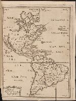
Kort beskrifning om provincien Nya Swerige uti America : som nu foertjden af the Engelske kallas
Image Count:
1
Description:
Preceding p. 1. and Teaching resource: Professor John Mack Faragher, History 141: The American West.
Subject (Geographic):
Canada --Discovery and exploration, South America --Discovery and exploration, United States --Discovery and exploration, and Western Hemisphere --Maps --Early works to 1800
Collection Created:
Stockholm : Tryckt uti Kongl. boktr. hos S. Wankijfs ankia, med egen bekostnad, af J. H. Werner, 1702
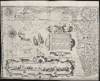
... Iohn Hvighen van Linschoten. his Discours of Voyages into ye Easte & West Indies. Deuided into
Image Count:
1
Abstract:
Engraved map depicts part of the south and west edge of Africa and also the islands of Ascension and Saint Helena within a special border.
Description:
[Scale ca. 1:13,000,000]., Bound in following title page of the second book., Map has been repaired with tape on verso., Map has black line on verso in center., Map has mirror image of brown marks on verso on bottom folded panels., and Map properly belongs to the Dutch edition of 1596.
Subject (Geographic):
Africa --Maps --Early works to 1800, Africa, West --Description and travel --Early works to 1800, Africa, West --Maps --Early works to 1800, Ascension Island (Atlantic Ocean) --Description and travel, and Saint Helena --Description and travel
Subject (Topic):
Voyages and travels --Early works to 1800
Collection Created:
Printed at London by Iohn Wolfe Printer to ye Honorable Cittie of London [1598]