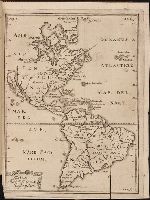
Kort beskrifning om provincien Nya Swerige uti America : som nu foertjden af the Engelske kallas
Image Count:
1
Description:
Preceding p. 1. and Teaching resource: Professor John Mack Faragher, History 141: The American West.
Subject (Geographic):
Canada --Discovery and exploration, South America --Discovery and exploration, United States --Discovery and exploration, and Western Hemisphere --Maps --Early works to 1800
Collection Created:
Stockholm : Tryckt uti Kongl. boktr. hos S. Wankijfs ankia, med egen bekostnad, af J. H. Werner, 1702
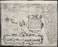
... Iohn Hvighen van Linschoten. his Discours of Voyages into ye Easte & West Indies. Deuided into
Image Count:
1
Abstract:
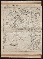
Engraved map depicts part of the south and west edge of Africa and also the islands of Ascension and Saint Helena within a special border.
Description:
[Scale ca. 1:13,000,000]., Bound in following title page of the second book., Map has been repaired with tape on verso., Map has black line on verso in center., Map has mirror image of brown marks on verso on bottom folded panels., and Map properly belongs to the Dutch edition of 1596.
Subject (Geographic):
Africa --Maps --Early works to 1800, Africa, West --Description and travel --Early works to 1800, Africa, West --Maps --Early works to 1800, Ascension Island (Atlantic Ocean) --Description and travel, and Saint Helena --Description and travel
Subject (Topic):
Voyages and travels --Early works to 1800
Collection Created:
Printed at London by Iohn Wolfe Printer to ye Honorable Cittie of London [1598]
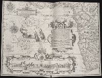
Descriptio ac delineatio geographica detectionis freti, sive, transitus ad occasum supra terras
Image Count:
1
Description:
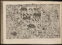
Bound in after p. [40]., Map has water stain on recto in upper right corner., Printed on recto in lower right corner: F., and Scale [ca. 1:10,000,000].
Subject (Geographic):
Barents Sea --Maps --Early works to 1800. and Norwegian Sea --Maps --Early works to 1800
Collection Created:
Amsterodami Ex officina Hesse lij Gerardi. Anno 1613
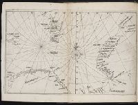
Eigentliche vnd warhafftige Beschreibung / der wunderbaerlichen Schiffarth (der Hollaender
Image Count:
1
Description:
Map has small brown mark on both the recto and verso at the bottom of the map frame below and to the left of the word "Linie"., Map has small water stain on both the recto and verso in the lower right corner of the page that meets with the gutter., Printed above map in center of page: Fol. 73., and Scale [ca. 1:6,500,000].
Subject (Geographic):
Borneo --Maps --Early works to 1800
Collection Created:
Gedruckt zu Amsterdam / Durch Cornelium Nicolaum / Anno 1602