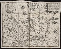
Nauigatio ac itinerarium Iohannis Hugonis Linscotani in Orientalem siue Lusitanorum Indiam
Image Count:
1
Description:
[Scale ca. 1:13,500,000]., Bound in following page 22., In pencil on middle left panel of left verso: 23., In pencil on middle right panel of left verso: 22-1., and Map has several areas of staining most noticeably along the top verso.
Subject (Geographic):
Borneo --Maps, China --Maps --Early works to 1800, Indonesia --Maps, Japan --Maps --Early works to 1800, Java (Indonesia) --Maps --Early works to 1800, and Philippines --Maps
Subject (Name):
Claesz, Cornelis, ca. 1546-1609, publisher, Elzevier, Gillis, bookseller, and Hendricksz, Aelbrecht, fl. 1573-1605, printer
Subject (Topic):
Voyages and travels --Early works to 1800
Collection Created:
Hagae-Comitis : Ex officina Alberti Henrici, impensis authoris & Cornelii Nicolai, prostantque apud Aegidium Elseuirum, anno 1599
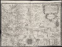
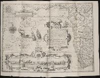
John Huighen van Linschoten, his Discours of Voyages into ye Easte & West Indies
Image Count:
1
Description:
[Scale ca. 1:13,500,000]., Bound in following p. 32., and Map has several small brown marks on the left portion that can also be seen on the verso.
Subject (Geographic):
Borneo --Maps --Early works to 1800, China --Maps --1368-1644, Japan --Maps --Early works to 1800, Java (Indonesia) --Maps --Early works to 1800, and Sumatra (Indonesia) --Maps
Subject (Name):
Wolfe, John, d. 1601, printer
Subject (Topic):
Voyages and travels --Early works to 1800
Collection Created:
[London] : Printed at London by [John Windet for] Iohn Wolfe, printer to ye Honorable Cittie of London, [1598]
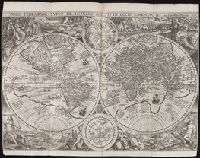
John Huighen van Linschoten, his Discours of Voyages into ye Easte & West Indies
Image Count:
1
Abstract:
Map features two hemispheres and two zodiac charts as well as representations including people, animals, structures, and plant life of the geographical areas of "Europa", "Asia", "Africa", Magallanica", "Peruana", and "Mexicana" within the remainder of the frame.
Description:
Bound in before p. 1., Ink from preceding portrait has bled onto verso of map., Map has some small tears along fold lines., and Map has two small stains of ink in the center below "La Ascension".
Subject (Topic):
Voyages and travels --Early works to 1800, World maps --Early works to 1800, and Zodiac --Early works to 1800
Collection Created:
[London] : Printed at London by [John Windet for] Iohn Wolfe, printer to ye Honorable Cittie of London, [1598]
Plancius, Petrus, 1552-1622. Orbis terrarum typus de integro multis in locis emendatus
Published / Created:
1594
Call Number:
Taylor 219
Collection Title:
Navigatio ac itinerarivm Iohannis Hvgonis Linscotani in Orientalem sive Lvsitanorvm Indiam
Image Count:
1
Abstract:
Major land masses known at the time are depicted in the corners of the map with representative fauna and flora as well as the people indigenous to those areas and their activities. Two astrological charts are positioned in the center, above and below the two hemispheres.
Alternative Title:
Orbis terrarum typus de integro multis in locis emendatus
Description:
[Scale ca. 1:45,000,000]., Bound in following page 4., and Map is torn in several areas and has been backed with another sheet of paper.
Subject (Geographic):
World maps --Early works to 1800
Subject (Name):
Claesz, Cornelis, ca. 1546-1609, publisher, Elzevier, Gillis, bookseller, Hendricksz, Aelbrecht, fl. 1573-1605, printer, and Langren, Arnold Florent van, 1580-1644
Subject (Topic):
Voyages and travels --Early works to 1800
Collection Created:
Hagae-Comitis : Ex officina Alberti Henrici, impensis authoris & Cornelii Nicolai, prostantque apud Aegidium Elseuirum, anno 1599
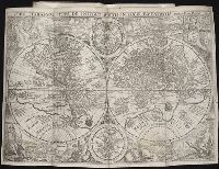
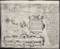
Nauigatio ac itinerarium Iohannis Hugonis Linscotani in Orientalem siue Lusitanorum Indiam
Image Count:
1
Description:
[Scale ca. 1:13,000,000]., Bound in following title page of "Descriptio totius Guineae tractus ...", In ink on top left panel of left verso: 3., and Map has several small tears now repaired on verso.
Subject (Geographic):
Africa, West --Maps --Early works to 1800
Subject (Name):
Claesz, Cornelis, ca. 1546-1609, publisher, Elzevier, Gillis, bookseller, and Hendricksz, Aelbrecht, fl. 1573-1605, printer
Subject (Topic):
Voyages and travels --Early works to 1800
Collection Created:
Hagae-Comitis : Ex officina Alberti Henrici, impensis authoris & Cornelii Nicolai, prostantque apud Aegidium Elseuirum, anno 1599
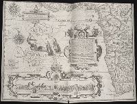
... Iohn Hvighen van Linschoten. his Discours of Voyages into ye Easte & West Indies. Deuided into
Image Count:
1
Abstract:
Engraved map depicts part of the south and west edge of Africa and also the islands of Ascension and Saint Helena within a special border.
Description:
[Scale ca. 1:13,000,000]., Bound in following title page of the second book., Map has been repaired with tape on verso., Map has black line on verso in center., Map has mirror image of brown marks on verso on bottom folded panels., and Map properly belongs to the Dutch edition of 1596.
Subject (Geographic):
Africa --Maps --Early works to 1800, Africa, West --Description and travel --Early works to 1800, Africa, West --Maps --Early works to 1800, Ascension Island (Atlantic Ocean) --Description and travel, and Saint Helena --Description and travel
Subject (Topic):
Voyages and travels --Early works to 1800
Collection Created:
Printed at London by Iohn Wolfe Printer to ye Honorable Cittie of London [1598]