Skip to search
Skip to main content
Skip to first result
Search
You Searched For
Publication Place
[United States :
New Search
Search Results
Published / Created:
19--?]
Call Number:
778 1781
Container / Volume:
BRBL_00504A
Image Count:
1
Resource Type:
Maps, Atlases & Globes
Description:
Reproduction of London, J. Bew, 1781, map issued by Colonial Williamsburg.
Publisher:
s.n.,
Subject (Geographic):
Chesapeake Bay (Md. and Va.)--Maps--Early works to 1800
Found in:
Beinecke Rare Book and Manuscript Library > A Map and Chart of these parts of the Bay of Chesapeak. York and James Rivers wich are at present the seat of war.
Published / Created:
c1931.
Call Number:
831am P93 1931
Container / Volume:
BRBL_00581
Image Count:
1
Resource Type:
Maps, Atlases & Globes
Alternative Title:
Map of Prickly Pear gold mines :
Description:
Copyright: W. Smith., Includes text about significant historical events and places., Pictorial map., and Relief shown pictorially and by spot heights.
Publisher:
s.n.],
Subject (Geographic):
Helena Region (Mont.)--History--Maps
Subject (Name):
Smith, W
Subject (Topic):
Gold mines and mining--Montana--Prickly Pear Creek Valley--Maps
Found in:
Beinecke Rare Book and Manuscript Library > A map of the Prickley Pear gold mines : with stage routes, towns, principal streams & points of historic interest to the traveler.
Creator:
Published / Created:
Circa 1849
Call Number:
Ydh 849p
Collection Title:
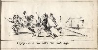
The college experience of Ichabod Academicus.
Image Count:
1
Publisher:
s.n.,
Subject (Name):
Mellon, Paul--Bookplate and Yale University--Caricatures and cartoons
Found in:
Manuscripts and Archives > A row with the town boys, from the college experience of Ichabod Academicus.
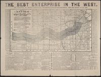
Published / Created:
1873?]
Call Number:
825gme 1873
Container / Volume:
BRBL_00576
Image Count:
2
Resource Type:
Maps, Atlases & Globes
Alternative Title:
Atchison, Topeka and Santa-Fe Railroad and connections., Best enterprise in the West., and Map of Kansas.
Description:
Date inferred from references to 1873 in text., In top margin: The best enterprise in the West., Includes text., and Relief shown by hachures.
Publisher:
s.n.,
Subject (Geographic):
Kansas--Maps
Subject (Name):
Atchison, Topeka, and Santa Fe Railroad Company, Atchison, Topeka, and Santa Fe Railroad Company--Maps, Bogart & Stillman, Fisk & Russell, and Poor, C
Subject (Topic):
Railroad land grants--Kansas--Maps, Railroads--Kansas--Maps, and Railroads--West (U.S.)--Maps
Found in:
Beinecke Rare Book and Manuscript Library > Atchison, Topeka & Santa-Fe Railroad and connections : with 3,000,000 acres land for sale on eleven years credit & seven percent interest / Fisk & Russell, N.Y. Map of Kansas / Atchison, Topeka & Santa-Fe Railroad ; Bogart & Stillman, engravers, Cin. O.
Creator:
Published / Created:
19--]
Call Number:
59 C126 1927
Container / Volume:
BRBL_00318
Image Count:
4
Resource Type:
Maps, Atlases & Globes
Alternative Title:
Bengal & Chandernagore
Description:
"Heliozincographed at the Survey of India Offices, Calcutta." in lower right margins., "Seasons 1918-21", "Seasons 1919-21", "Seasons 1920-22", and "Seasons 1905-06, 1920-21" in upper left margins., Includes index to sheets, index to districts., and No. 79 B/N.W
Publisher:
s.n.,
Subject (Geographic):
Bengal (India)--Maps and Chandernagore (India)--Maps
Subject (Name):
Tandy, Edward Aldborough, Sir, 1871-
Found in:
Beinecke Rare Book and Manuscript Library > Bengal / published under the direction of Colonel Commandant E.A. Tandy, R.E., Surveyor General of India.
Creator:
Published / Created:
19--]
Call Number:
59 B639 1932
Container / Volume:
BRBL_00318
Image Count:
5
Resource Type:
Maps, Atlases & Globes
Description:
"Heliozincographed at the Survey of India Offices, Calcutta." in lower right margins., "Surveyed 1924-25" in upper left margins., Includes index to sheets, index to districts., and No. 47 A/15 and A/11. Bombay Suburban & Thāna Districts [Sheet 1] -- No. 47 E/3.
Publisher:
s.n.,
Subject (Geographic):
Bombay (India)--Maps
Subject (Name):
Gunter, C.P
Found in:
Beinecke Rare Book and Manuscript Library > Bombay / published under the direction of Lieutenant Colonel C.P. Gunter, O.B.E., R.E., Officiating Surveyor General of India, 1926.
Creator:
Published / Created:
1871
Call Number:
814 B731 1871
Container / Volume:
BRBL_00558
Image Count:
1
Resource Type:
Maps, Atlases & Globes
Description:
"The Lake Superior and Puget Sound Co., Proprieters." and Relief shown by hachures.
Publisher:
s.n.],
Subject (Geographic):
Brainerd (Minn.)--Maps
Subject (Name):
Lake Superior and Puget Sound Company
Found in:
Beinecke Rare Book and Manuscript Library > Brainerd, Crow Wing Co., 1871, Minnesota / Joseph E. Turner, C.E. surveyor.
Published / Created:
ca. 1900]
Call Number:
765 P94 1900
Container / Volume:
BRBL_00464
Image Count:
2
Resource Type:
Maps, Atlases & Globes
Description:
Cadastral map., Library has plates 1 and 8., and Sheets include consecutive page no. in top left and right corners.
Publisher:
s.n.,
Subject (Geographic):
Providence (R.I.)--Maps
Subject (Topic):
Real property--Rhode Island--Providence--Maps
Found in:
Beinecke Rare Book and Manuscript Library > City of Providence.
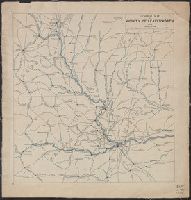
Published / Created:
1913
Call Number:
825 L487 1913
Container / Volume:
BRBL_00574
Image Count:
1
Resource Type:
Maps, Atlases & Globes
Description:
Shows railroad lines through portions of Nebraska, Iowa, Kansas, and Missouri.
Publisher:
s.n.],
Subject (Topic):
Railroads--Kansas--Leavenworth Region--Maps
Found in:
Beinecke Rare Book and Manuscript Library > General map of vicinity of Leavenworth.
Creator:
Published / Created:
between 1844 and 1899?]
Call Number:
815ca 1890
Container / Volume:
BRBL_00561
Image Count:
1
Resource Type:
Maps, Atlases & Globes
Description:
Below title area: C.B. Graham, lithogr., Coordinates not present on map and are approximated., Relief shown by hachures., and Shows lead mines and copper, iron and zinc ores.
Publisher:
s.n.,
Subject (Name):
Graham, C. B. (Curtis B.)
Subject (Topic):
Geology--Illinois--Maps, Geology--Iowa--Maps, Geology--Wisconsin--Maps, Mines and mineral resources--Illinois--Maps, Mines and mineral resources--Iowa--Maps, and Mines and mineral resources--Wisconsin--Ma
Found in:
Beinecke Rare Book and Manuscript Library > Geological chart of part of Iowa, Wisconsin, and Illinois / by D.D. Owen.
Branch:v1.61.6 ,Deployed:2024-06-12T09:55:33-04:00