Indexed atlas of the world map of Mexico and Rand, McNally & Co.'s indexed atlas of the world map of Mexico
Description:
Includes "Map of the Valley of Mexico." Scale ca. [1:400,000]., On verso: Plan of the city of Mexico. Scale [ca. 1:16,000] -- Valley of Mexico. Scale [ca. 1:172,000]., Relief shown by hachures and spot heights., and Shows railroads.
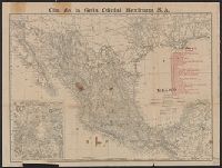
Indexed atlas of the world map of Mexico, Plano general de la ciudad de Mexico., and Rand, McNally & Co.'s indexed atlas of the world map of Mexico
Description:
"Cia. de la Guia Oficial Mexicana S.A.", Includes index to railroads and "Map of the Valley of Mexico, on enlarged scale" (scale [ca. 1:300,000])., On verso: Plano general de la ciudad de Mexico / formado de esprofeso p.a la C.a de la Guia Oficial Mexicana ; Luis G. Becerril. Scale 1:15,000. 1903., and Relief shown by hachures and spot heights.
Publisher:
Rand, McNally,
Subject (Geographic):
Mexico City (Mexico)--Maps and Mexico--Maps
Subject (Name):
Cia. de la Guia Oficial Mexicana S.A
Subject (Topic):
Railroads--Mexico--Maps and Streets--Mexico--Mexico City--Maps
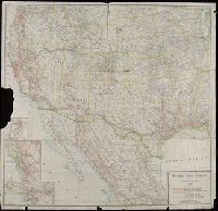
Copyright: Southern Pacific Co., Covers states west of the Mississippi River and area in Mexico north of Mexico City., Insets: Portland and vicinity -- San Francisco and vicinity -- Los Angeles and vicinity., and Library's copy imperfect: Part of Portland inset torn away.
Publisher:
Rand McNally & Co.,
Subject (Name):
Southern Pacific Railroad Company--Maps
Subject (Topic):
Railroads--Mexico--Maps and Railroads--West (U.S.)--Maps
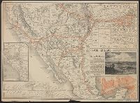
Santa Fé route : and Santa Fé route to the city of Mexico by the Atchison, Topeka and Santa Fé R.R. and Mexican Central R.R.
Description:
"February" on panel and "November 29, 1885" on timetable., Covers southweste, Relief shown by hachures., Shows cities and towns, stations, Indian reservations, state boundaries, and the railroad network emphasizing the main line., and Text and timetable on verso.
Publisher:
Rand, McNally,
Subject (Name):
Atchison, Topeka, and Santa Fe Railroad Company, Atchison, Topeka, and Santa Fe Railroad Company--Maps, Mexican Central Railway Co, and Mexican Central Railway Co.--Maps
Subject (Topic):
Railroads--Mexico--Maps, Railroads--Mexico--Timetables, Railroads--Southwestern States--Maps, and Railroads--Southwestern States--Timetables