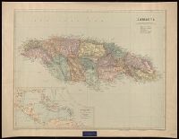
"2827.", "BCM/Stanfordmaps.", "Printed in Great Britain.", Includes ancillary map, "The West Indies and Central America.", Label: International Map Company ... New York, N.Y. Backed with linen., and Relief shown by shading and spot heights.
Publisher:
Edward Stanford Ltd., 12, 13, & 14 Long Acre W.C.,
Subject (Geographic):
Jamaica--Maps.
Subject (Name):
Edward Stanford Ltd. and International Map Company Bookplate.
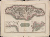
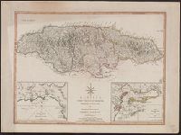
"Drawn & engraved for John Thomson & Co.'s New general atlas.", "T. Clerk, sculpt.", Relief shown by hacures and pictorially., Scale given in "statute miles 69 1/2 to a degree," and "sea leagues 20 in a degree.", and Sheet measures 53.7 x 69.6 cm. Label on verso: No. 62.
Publisher:
John Thomson & Co.],
Subject (Geographic):
Jamaica--Maps
Subject (Name):
Clerk, T. (Thomas), engraver and John Thomson & Co. New general atlas
Subject (Topic):
Harbors--Jamaica--Kingston--Maps and Harbors--Jamaica--Port Royal--Maps
"T. Clerk, sculpt.", Cf. Kapp, K.S. Printed maps of Jamaica up to 1825, 145., Cross Collection no. 290., From John Thomson & Co.'s New general atlas., Imperfect: torn along fold, with no loss of text., Label: No. 62., Relief shown by hacures and pictorially., and Variant without publishing statement at bottom.
Publisher:
John Thomson & Co.,
Subject (Geographic):
Jamaica--Maps
Subject (Name):
Clerk, T. (Thomas), engraver and John Thomson & Co. New general atlas
Subject (Topic):
Harbors--Jamaica--Kingston--Maps and Harbors--Jamaica--Port Royal--Maps
Harbour of Bluefields. and Harbours of Kingston and Port Royal.
Description:
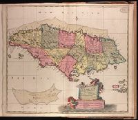
Cross Collection no. 289., From Thomas Kitchin's New universal atlas. 6th ed. London : Robert Laurie and James Whitt, Prime meridians: Ferro and London., Printed no. on verso: 65., and Relief shown by hachures; soundings in fathoms.
Publisher:
Laurie & Whittle,
Subject (Geographic):
Jamaica--Maps--Early works to 1800, Kingston (Jamaica)--Maps--Early works to 1800, and Port Royal (Jamaica)--Maps--Early works to 1800
Subject (Name):
Kitchin, Thomas, 1718-1784. New universal atlas and Laurie & Whittle
Subject (Topic):
Harbors--Jamaica--Kingston--Maps--Early works to 1800 and Harbors--Jamaica--Port Royal--Maps--Early works to 1800
"Cum privilo. ordinm. Generalm. Belgii Foederati.", Backed with paper. Ms. no. "96" in upper right-hand corner. Sheet measures 53.6 x 62.9 cm. No. 86 of 87 maps bound together., Includes three bar scales., and Relief shown pictorially.
Publisher:
[Nicolaes Visscher,
Subject (Geographic):
Jamaica--Maps--Early works to 1800.
Subject (Name):
Albany Institute Stamp. and Anse, Luggert van, fl. 1690-1716, engraver.