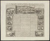
Vue and description de la ville de Lovango dans le royaume de Congo avec plusieurs
Description:
"Tom VI, no. 16, pag. 66.", Caption title., Engraving of bird's-eye view of "Lovango" at top, with 10 vignettes surrounding descriptive text in the middle., and From Chatelain's Atlas historique, 1718-1732.
Subject (Geographic):
Kongo Kingdom--Description and travel--Early works to 1800 and Kongo Kingdom--Pictorial works--Early works to 1800
Imray, James F. (James Frederick), 1829?-1891, cartographer James Imray and Son, issuing body
Call Number:
23cea 1886
Container / Volume:
BRBL_00021
Image Count:
2
Resource Type:
Maps, Atlases & Globes
Alternative Title:
Western Pacific, sheet no. 4
Description:
Hydrographic chart of the western Pacific Ocean, including eastern Australia, Papua New Guinea, the Solomon Islands, New Hebrides, New Caledonia, and the northwest of New Zealand., Mellish Reef., and Relief shown by hachures and spot heights. Depth shown by iso
Subject (Geographic):
Melanesia--Maps and Pacific Ocean--Maps
Subject (Topic):
Nautical charts--Melanesia and Nautical charts--Pacific Ocean
Russia. Turkestanskiĭ Voennyĭ Okrug Voenno Topograficheskiĭ Otdel Россия. Туркестанский Военный Округ Военно Топографический Отдел
Call Number:
547 1892A
Container / Volume:
BRBL_00291
Image Count:
3
Resource Type:
Maps, Atlases & Globes
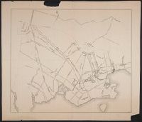
Alternative Title:
Zakaspiiskoĭ Oblasti, Закаспийской Области, and Закаспійской Области.
Description:
E.7. -- E.8. -- F.7., Imperfect: some sheet chipped at edges, with some loss of text; some sheets wanting. Dissected and mounted on linen., and Relief shown by shading.
Bookseller's labels: Landbergs; G. Hedberg ... Stockholm. Bookplate of Alarik Waghtmeister. Manuscript annotations on front paste-down endpaper of cover; title on cover "Johan Monssons Karta öfver Östersjön.", Coordinates not present on map and are approximated., Depths shown by soundings., Includes dedication from "Johan Mansson.", North oriented towards the bottom., Title devised by cataloger., and Watermark.
Cosmographia Petri Apiani / per Gemmam Frisium apud Louanienses medicum et mathematicum insignem, iam demum ab omnibus vindicata mendis, ac nonnullis quoque locis aucta, & annotationibus marginalibus illustrata. ; Additis eiusdem argumenti
Contents:
"Itinerary of the march of the Right Wing of the Second Regiment of the W.T. Vols. under command of Lieutenant Colonel Shaw, from Montgomery's to Grande Ronde," Jun 12-Aug 29, 1856. To Governor I. I. Stevens. 49 p.
Map, "Plan of the battle of Grande Ronde fought Jul 17, 1856." 18.5 x 22 cm.
Subject (Name):
De Lacy, W. W. (Walter Washington), 1819-1892, Shaw, B. F. (Benjamin Franklin), 1829 or 1830-1908, and Stevens, Isaac Ingalls, 1818-1862