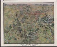
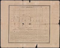
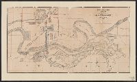
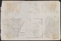
Description derived from published bibliography. and Panoramic map, with Round Top in the foreground, showing roads, railroads, field patterns, woodland, observation towers, monuments, and houses.
Carte de la Louisiane ou des voyages du Sr. De La Salle
Description:
"Reduced facsimile of MS. copy (made in Paris for Francis Parkman), now in the Library of Harvard University. The original, formerly in the Archives de la Marine, Paris, has been lost.", Facsimile., From the Jesuit Relations, vol. 63, frontispiece., and Relief shown pictorially.
Publisher:
s.n.,
Subject (Geographic):
New France--Maps--Early works to 1800--Facsimiles. and North America--Maps--Early works to 1800--Facsimiles.
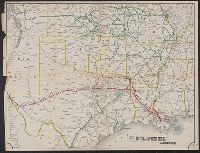
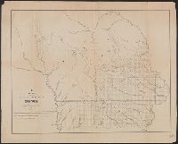
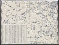
Map of the Texas & Pacific Railway and connections, Map of the Texas and Pacific Railway and connections, Texas & Pacific Railway and connections, and Texas and Pacific Railway and connections
Description:
Relief shown by hachures. and Shows Texas & Pacific Railway in red.
Publisher:
s.n.,
Subject (Name):
Texas & Pacific Railway--Maps
Subject (Topic):
Railroads--Southwestern States--Maps and Railroads--Texas--Maps
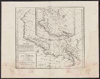
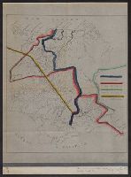
Part of the boundary between the United States and Texas, north of Sabine River from the 36th to the 72nd mile mound
Description:
"Though the map ... has an 1840 date, it appears from a letter of J.H. Overton, United States Commissioner, dated Opelousas, Louisiana, August 10, 1841 ... and the reply of October 1, 1841 ... that the maps ... had not been forwarded at that time. However, they had been received by January 15, 1842 ... and that they were issued by March 17, 1842, is shown by the reprintings of them accompanying the President's message of that date"--Streeter, T.W. Bibliography of Texas, 1438., At head of title: B.2., From the Streeter collection., Relief shown by hachures., and Three parallel sections of 12 miles each.
Publisher:
s.n.,
Subject (Geographic):
Texas--Boundaries--United States--Maps and United States--Boundaries--Texas--Maps
Subject (Name):
Streeter, Thomas W.--(Thomas Winthrop),--1883-1965--Ownership
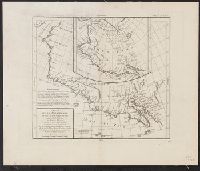
"Though the map ... has an 1840 date, it appears from a letter of J.H. Overton, United States Commissioner, dated Opelousas, Louisiana, August 10, 1841 ... and the reply of October 1, 1841 ... that the maps ... had not been forwarded at that time. However, they had been received by January 15, 1842 ..and that they were issued by March 17, 1842, is shown by the reprintings of them accompanying the President's message of that date"--Streeter, Bibliographof Texas, 1438., At head of title: A.2., From the Streeter collection., Relief shown by hachures., and Three parallel sections of 12 miles each.
Publisher:
s.n.,
Subject (Geographic):
Texas--Boundaries--United States--Maps and United States--Boundaries--Texas--Maps
Subject (Name):
Streeter, Thomas W.--(Thomas Winthrop),--1883-1965--Ownership
Red River, Sabine & Western Railway and Red River, Sabine and Western Railway
Description:
"I.[?] C. Terry, Chf. Eng.", Covers Texas and Louisiana, and parts of New Mexico, Indian Territory, Arkansas, Mississippi, and northern Mexico., From the Streeter collection., and Library's copy imperfect: Holes in center.
Publisher:
s.n.,
Subject (Name):
Red River, Sabine and Western Railway--Maps and Streeter, Thomas W.--(Thomas Winthrop),--1883-1965--Ownership
Subject (Topic):
Coal--Texas--Maps, Forests and forestry--Louisiana--Maps, Forests and forestry--Texas--Maps, Iron--Texas--Maps, Petroleum--Texas--Maps, Railroads--Louisiana--Maps, and Railroads--Texas--Maps
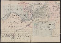
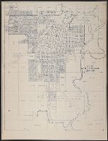
"S.N. Simpson, real estate dealer, office 505 Delaware St., Kansas City and at Riverview.", Riverview map includes text., and Shows numbered lots and property owners.
Publisher:
s.n.,
Subject (Geographic):
Kansas City Metropolitan Area (Kan.)--Maps, Kansas City Metropolitan Area (Mo.)--Maps, and Riverview (Kan.)--Maps
Subject (Name):
O'Flaherty, Daniel, civil eng'r, Ramsey, Millett & Hudson, Simpson, S. N, and Smith, D. M
Subject (Topic):
Real property--Kansas--Kansas City Metropolitan Area--Maps, Real property--Kansas--Riverview--Maps, and Real property--Missouri--Kansas City Metropolitan Area--Maps
Blue line print., Shows landowners, oil and gas wells, abandoned wells, dry holes, railroads, and Prairie pipeline., and Title devised by cataloger.
Publisher:
s.n.,
Subject (Name):
Tarbell, F. S. (F. Scott)
Subject (Topic):
Gas wells--Kansas--Anderson County--Maps, Landowners--Kansas--Anderson County--Maps, Oil wells--Kansas--Anderson County--Maps, and Real property--Kansas--Anderson County--Maps
Stamped on verso: The Library of Congress duplicate ... Jan. 1945., Stamped: Chamber of Commerce, Coffeyville, Kansas., and Title devised by cataloger.
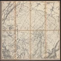
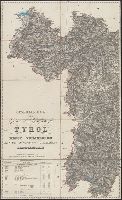
In bottom margin: Photolithographed preliminary sheet for the use of the parties in the field and subject to revision., In top margin: Northe, Library's copy separated into two sheets (59 x 58 cm. and 59 x 55 cm.)., and Relief shown by contours and spot heights.
Publisher:
Northern Transcontinental Survey?],
Subject (Geographic):
Judith River Watershed (Mont.)--Maps, Topographic
Subject (Name):
Julius Bien & Co, Northern Transcontinental Survey. Topographical Dept, and Owen, F. D
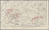
Blueprint., In lower left: 77., Includes note certifying map., Relief shown by hachures., and Shows trails of Genl. Miles, Col. Baker, Capt. Snyder, and Lt. Woodruff in lands near Missouri and Yellowstone rivers in Montana.
Publisher:
s.n.,
Subject (Geographic):
Montana--Maps, Military and Yellowstone River Valley--Maps, Military
"Delineada en vista de las cartas de Don Pedro Maldonado, el Baron de Humboldt, Mr. Wisse, la de las sontas de las costas por M.M. Filzroy i H. Kellet i las particular, Includes table of names of provinces, cantons, parishes, etc., and Relief shown by hachures.
"Delineada en vista de las cartas de Don Pedro Maldonado, el Baron de Humboldt, Mr. Wisse, la de las sontas de las costas por M.M. Filzroy i H. Kellet i las particular, Includes table of names of provinces, cantons, parishes, etc., and Relief shown by hachures.
A strip of paper has been overlaid within the lower left neat line., Central Venice and some outlying areas appear finished, but there are extensive unfinished areas with notations in pencil., dgvmp2008., and Map extends beyond neat lines.
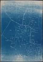
Blue line print., In lower left corner: R.W.D., Nov. 21, 1910. R 12-1-10. S, 4/1/12-S2 4/1/12., In lower right margin: Tolland Co. Conn, 905., and Indicates lettered routes, post offices, houses, schools, churches, and collection boxes.
Publisher:
s.n.],
Subject (Geographic):
Tolland County (Conn.)--Maps
Subject (Topic):
Postal service--Connecticut--Tolland County--Maps and Rural free delivery--Connecticut--Tolland County--Maps
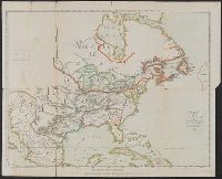
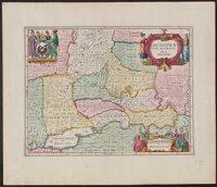
Appears in Jansson's Atlas novus, vol. 1, ca. 1680; also appears in the English Atlas, vol. 1, by Moses Pitt et al., ca. 1680., Bottom center: "Ex officina Janssonio-Waesbergiana, et Mosis Pitt.", Relief shown pictorially., and Sheet measures 54 x 62 cm. Numbered "6" in ink ms. Lada-Mocarski Collection.
Publisher:
s.n.,
Subject (Geographic):
Russia--Maps--Early works to 1800
Subject (Name):
Jansson, Jan, 1588-1664. Atlas novus and Pitt, Moses, active 1654-1696. English atlas
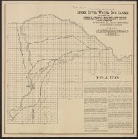
"Offices: J.M. Clifford ... Idaho. Fowler & Lummis ... Pa. International Immigrant Union ... Ill. Wm. H. Martin, manager.", Date inferred from latest date mentioned in text., and Includes text.
Publisher:
s.n.,
Subject (Geographic):
Bingham County (Idaho)--Maps
Subject (Name):
International Immigrant Union, Matthews-Northrup Company, and Snake River Water Co
Includes inset of numbered lots between River and High, First and Eighth streets, list of mines, and text describing Wallace's location. and Relief shown by hachures and shading.
"The colored portions exhibits [sic] the 41 shares belonging to Marsh, Lee, & Delavan, Trustees &c.", Date inferred from date in text., Includes text by O.S.X. Peck and Joel C. Walker certifying map., and Oriented with north to right.
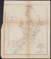
Chrrah tanka; the Great Hills or Coteau De Prairie. and Minnay shoshoh chrray; or Great Hills of the Missouri.
Description:
Includes Indian and French terms., Includes maps of "Minnay shoshoh chrray; or Great Hills of the Missouri," and "Chrrah tanka; the Great Hills or Coteau De Prairie.", Relief shown by hachures., and Shows points of interest and topography.
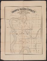
"J. L. Van Doren, Henry Pease, proprietors.", "Thos Moore's Lithy Boston.", Includes "Prospectus" and location map showing "chartered & contemplated" railroads., and Shows numbered lots, parks, and ill. of steamboats and selected buildings.
Library's copy missing top left section where title block appears., Relief shown pictorially and by hachures., Shows "Mex. Central Railway," "Mex. National Railway," "Mexican (Vera Cruz) Railway," "Interoceanic (Irolo) Railway," and "Interoceanic (Morelos) Railway;" and "Lago de Texcoco," "Lago de Xochimilco," and "Lago de Chalco.", and Title devised by cataloger.
Includes 6 vignettes of town buildings and structures., Insets: Hicksville [ca. 1:7,920] -- Smith Mills [ca. 1:7,920] -- South Dartmouth [1:7,920] -- Russell Mills [1:7,920]., Relief shown by hachures., and Shows buildings with names of property owners and town
"St. Mary's of Aransas, once a leading town of Refugio County and for a short time county seat, flourished from about 1850 to 1886"--Huson, Hobart. St. Mary's of Aransas, Texas in Handbook of Texas online. c1997-2000., Cadastral map., and Includes text describing the town.
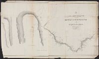
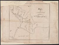
Survey of five leagues of land belonging to Wm P. Harris & others
Description:
"...in the 1837 [New Orleans] directory...P. Snell was listed, 'Canal near Bourbo, Library's copy imperfect: upper left corner missing., Oriented with north toward lower right., and Shows land tracts west of Galveston Bay and north of Clear Lake and Clear Creek.
Publisher:
s.n.,
Subject (Geographic):
Harris County (Tex.)--Maps
Subject (Name):
Harris, William P, Snell, P, and Streeter, Thomas W.--(Thomas Winthrop),--1883-1965--Ownership
"Though the map ... has an 1840 date, it appears from a letter of J.H. Overton, United States Commissioner, dated Opelousas, Louisiana, August 10, 1841 ... and the reply of October 1, 1841 ... that the maps ... had not been forwarded at that time. However, they had been received by January 15, 1842 ... and that they were issued by March 17, 1842, is shown by the reprintings of them accompanying the President's message of that date"--Streeter, T.W. Bibliography of Texas, 1438., At head of title: C.2., From the Streeter collection., and Three parallel sections, two of twelve miles each and one of 10 miles.
Publisher:
s.n.,
Subject (Geographic):
Texas--Boundaries--United States--Maps and United States--Boundaries--Texas--Maps
Subject (Name):
Streeter, Thomas W.--(Thomas Winthrop),--1883-1965--Ownership
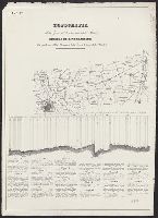
General profile of the road-bed of the Mo.R.F.S. & G.R.R., showing the elevation of the road bed, stations, streams & summits, relative distances & gradients.
Description:
Date inferred from status of Miissouri River, Fort Scott & Gulf Railroad, shown complete to Baxter Springs (1870). and Includes "General profile of the road-bed of the Mo.R.F.S. & G.R.R., showing the elevation of the road bed, stations, streams & summits; relative distances & gradients" (scale vertical [1:4,800] and horizontal [1:480,000]).
"For sale by the Atchison Topeka & Santa Fe Rail Road Company on 5 years credit and 7 percent interest." and Shows lands, railroads, and wagon roads in Pottawatomie, Jackson, Wabaunsee, and Shawnee counties in Kansas.
Publisher:
s.n.,
Subject (Geographic):
Kansas--Maps
Subject (Name):
Atchison, Topeka, and Santa Fe Railroad Company and Cutler, A. F.--Stamp
Library's copy annotated in ink and color pencil to show details of railroads' grounds, depots, transfers, etc., Oriented with north to the left., Relief shown by hachures., and Shows lines crossing from Omaha, Neb. area to Council Bluffs, Iowa area, railroad company grounds, and depots.
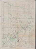
"Compiled at T.C.S. Jan. 1946 from revision of 30 Nov. 1943 from seven mile, Magic, Oak View east & west sheet.", "N 3902.12 W 9641.58 8.6 x 8.7.", "Reproduced at Fort Riley, Kansas H-277-1-2-3-4.", and Relief shown by contours and spot heights.
Publisher:
s.n.,
Subject (Geographic):
Fort Riley Region (Kan.)--Maps
Subject (Name):
Geological Survey (U.S.), U.S. Coast and Geodetic Survey, United States. Army. Corps of Engineers. Little Rock District, and United States. Army. Photographic Squadron, 1st
"Avertissement: La réduction sur plus grande échelle est faite d'après l'Amérique en 4 f. de Vischer que l'on pourroit datter de 1612 étant assés conforme a celle de Mercator avec quelques corrections ... La réduction sur plus petite échelle, en forme de supplement, est tirée de la grande Mappemonde plate de Pierre Plantius publiée par Piscator (le même que Vischer) et dédiée à Louis 13 en 1641."
Publisher:
s.n.,
Subject (Geographic):
California--Maps--Early works to 1800 and North America--Maps--Early works to 1800
"Avertissement: La réduction sur plus grande échelle est faite d'après l'Amérique en 4 f. de Vischer que l'on pourroit datter de 1612 étant assés conforme a celle de Mercator avec quelques corrections ... La réduction sur plus petite échelle, en forme de supplement, est tirée de la grande Mappemonde plate de Pierre Plantius publiée par Piscator (le même que Vischer) et dédiée à Louis 13 en 1641."
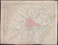
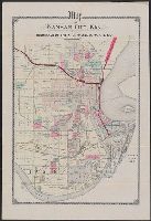
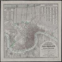
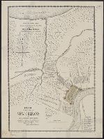
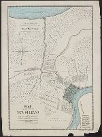
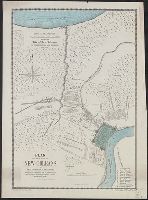
"Entered according to act of Congress in the year 1877 by T.S. Hardee in the office of the Librarian of Congress at Washington.", Also shows street railroads., Includes indexes and population figures., and Library's copy shows scale corrected in red ink from "feet" to "yds."
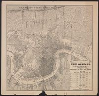
"Copy and translation from the original Spanish plan dated 1798, showing the city of New Orleans, its fortifications and environs. April 1875.", Drawn by Alexander Debrunner., Library's copy 3 colored only within city boundaries., and Printed by H. Wehrmann, No.
Also shows township and range grid, railroad routes, and property ownership along Mississippi., Depths shown by soundings., and Includes population table, "The Census, 1870-1880."
"Copy and translation from the original Spanish plan dated 1798, showing the city of New Orleans, its fortifications and environs. April 1875.", Drawn by Alexander Debrunner., Library's copy 3 colored only wi, and Printed by H. Wehrmann, No. 90 Exch. Alley, N.O.
"Copy and translation from the original Spanish plan dated 1798, showing the city of New Orleans, its fortifications and environs. April 1875.", Drawn by Alexander Debrunner., Library's copy 3 colored only wi, and Printed by H. Wehrmann, No. 90 Exch. Alley, N.O.
For another copy see entry no. 433., From "39th Cong., 1st Sess. [1866]-Report of the Chief Engineer, U.S.A.", and Legend in the upper left corner contains a brief resume of each day's action while the map shows troop positions, roads, railroads, hachures, drainage, vegetation, and rural houses. Streets and houses of Nashville are not indicated.
Publisher:
s.n.],
Subject (Geographic):
Nashville (Tenn.)--History--Civil War, 1861-1865--Maps
Includes inset of D. Russ Wood addition and advertisement. and Shows township lines, water pipes, gas pipes, fire plugs, street names and places of interest.
At bottom: For lots in these additions apply to, Porter, Raymond & Co., 1644 Curtis St. or Miller & Haekler, 1606 Curtis St., Date inferred from reference to "stone sidewalks will be laid and trees planted during the season of 1891.", and Includes text.
Publisher:
s.n.,
Subject (Geographic):
Denver Metropolitan Area (Colo.)--Maps
Subject (Name):
Mills Eng. Co
Subject (Topic):
Real property--Colorado--Denver Metropolitan Area--Maps
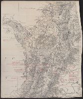
"Bvt. Maj. Gen. A.A. Humphreys, Chief of Engineers.", "Compiled under the direction of Bvt. Col. Wm. F. Merrill, Maj. Engrs, St. Louis, 1869.", Also shows parts of adjoining states., Includes list of "authorities.", and Relief shown by hachures.
Publisher:
s.n.,
Subject (Geographic):
Colorado--Maps and Utah--Maps
Subject (Name):
Humphreys, A. A. (Andrew Atkinson), 1810-1883, Merrill, Wm. F, R.P. Studley Co, and Sherman, William T. (William Tecumseh), 1820-1891
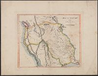
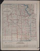
Map of the territory acquired from Mexico by the Gadsden Treaty, 1854.
Description:
Covers Nebraska extending to the Canadian border and westward to Oregon and Kansas including present day Colorado., Includes ill. and insets of United States and "Map of the territory acquired from Mexico by the Gadsden Treaty, 1854.", and Relief shown by hachures.
Publisher:
s.n.,
Subject (Geographic):
Kansas--Maps, Nebraska--Maps, and West (U.S.)--Maps
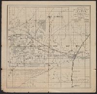
"F.R. Conway, Surveyor of the public lands in the states of Illinois and Missouri.", At head of title: (H)., Date inferred from reference in text to appropriations of March 1847 and fiscal year 1848-9 estimates., Includes text., and Shows townships and sections.
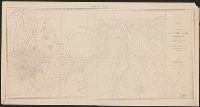
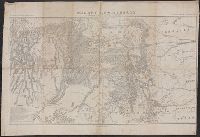
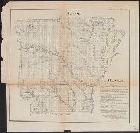
Arkansas., Diagram of the surveying district south of Tennessee., Map of the district north of Red River and part of N.W. District, LA., Map of the southwestern district, Louisiana., Sketch of the public surveys in Iowa Territory., and South eastern district Louis
Description:
At top of Arkansas map: A(1). and Shows township grids.
Publisher:
s.n.,
Subject (Geographic):
Arkansas--Maps, Iowa--Maps, Louisiana--Maps, and Mississippi--Maps
Blue line print., Relief shown by hachures., Shows numbered land lots., and Stamped "J.A. Vincent, Philadelphia, 421 Chestnut Street.", Ms. notes in red and yellow pencil.
Boundary lines noted in hand-colored ink., Ms. notes along bottom right margin: "Taken from map without title, property of the United Fruit Co.", and Positive photostat.
Insets: Vista de ma Mina de Corbou descubierta per F. Ferrer en Choutáles -- Plan y vista de las Minas Luigalpa en Choudales -- Plan de hatogrande en Choudales., Prime meridians: Washington - Greenwich., and Relief shown by hachures; depths shown by isolines.
North east districts, Portland., North-northwest district, Portland., S.E. district Portland., and S.W. district Portland.
Description:
Copyright: Henry R. Staats., Indexed., Sheets of map separately titled: North-northwest district, Portland -- North east districts, Portland -- S.W. district Portland -- S.E. district Portland., and Title devised by cataloger.
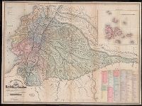
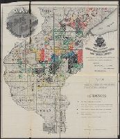
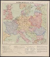
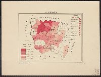
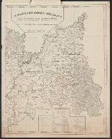
The Nationalities in the Roumanian territory of Hungary (Transylvania, the Adjoining Counties and the Banat)
Description:
"This map is a facsimile reproduction of the original map, published in addition to the book "The Races of Hungary," (A nepfajok Magyarorszagon), by the Hungarian professor Paul Balogh..." and 2 attached sheets with text in English.
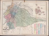
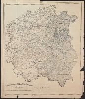